Читать книгу Byzantine Constantinople, the walls of the city and adjoining historical sites - Alexander Van Millingen - Страница 5
На сайте Литреса книга снята с продажи.
CHAPTER II.
THE CITY OF CONSTANTINE—ITS LIMITS—FORTIFICATIONS—INTERIOR ARRANGEMENT.
ОглавлениеTable of Contents
In the year 328 of our era, Constantine commenced the transformation of Byzantium into New Rome by widening the boundaries of the ancient town and erecting new fortifications.
On foot, spear in hand, the emperor traced the limits of the future capital in person, and when his courtiers, surprised at the compass of the circuit he set himself to describe, inquired how far he would proceed, he replied, “Until He stops Who goes before me.”[40] The story expresses a sense of the profound import of the work begun on that memorable day. It was the inauguration of an epoch.
We shall endeavour to determine the limits assigned to the city of Constantine. The data at our command for that purpose are, it is true, not everything that can be desired; they are often vague; at other times they refer to landmarks which have disappeared, and the sites of which it is impossible now to identify; nevertheless, a careful study of these indications yields more satisfactory results than might have been anticipated under the circumstances.
The new land wall, we shall find, crossed the promontory[41] along a line a short distance to the east of the Cistern of Mokius on the Seventh Hill, (the Tchoukour Bostan, west of Avret Bazaar), and of the Cistern of Aspar at the head of the valley between the Fourth and Sixth Hills, (the Tchoukour Bostan on the right of the street leading from the Mosque of Sultan Mehemet to the Adrianople Gate). The southern end of the line reached the Sea of Marmora somewhere between the gates known respectively, at present, as Daoud Pasha Kapoussi and Psamathia Kapoussi, while its northern extremity abutted on the Golden Horn, in the neighbourhood of the Stamboul head of the inner bridge. At the same time the seaward walls of Byzantium were repaired, and prolonged to meet the extremities of the new land wall.
That this outline of the city of Constantine is, substantially, correct, will appear from the information which ancient writers have given on the subject.
(a) According to Zosimus,[42] the land wall of the new capital was carried fifteen stadia west of the corresponding wall of Byzantium. The position of the latter, we have already seen, is marked, with sufficient accuracy for our present purpose by the porphyry Column of Constantine which stood close to the main gate of the old Greek town.[43] Proceeding from that column fifteen stadia westwards, we come to a line within a short distance of the reservoirs above mentioned.
(b) In the oldest description of Constantinople—that contained in the Notitia[44]—the length of the city is put down as 14,075 Roman feet; the breadth as 6150 Roman feet. The Notitia belongs to the age of Theodosius II., and might therefore be supposed to give the dimensions of the city after its enlargement by that emperor. This, however, is not the case. The size of Constantinople under Theodosius II. is well known, seeing the ancient walls which still surround Stamboul mark, with slight modifications, the wider limits of the city in the fifth century. But the figures of the Notitia do not correspond to the well-ascertained dimensions of the Theodosian city; they fall far short of those dimensions, and therefore can refer only to the length and breadth of the original city of Constantine. To adhere thus to the original size of the capital after it had been outgrown is certainly strange, but may be explained as due to the force of habit. When the Notitia was written, the enlargement of the city by Theodosius was too recent an event to alter old associations of thought and introduce new points of view. “The City,” proper, was still what Constantine had made it.
The length of the original city was measured from the Porta Aurea on the west to the sea on the east. Unfortunately, a serious difference of opinion exists regarding the particular gate intended by the Porta Aurea. There can be no doubt, however, that the sea at the eastern end of the line of measurement was the sea at the head of the promontory; for only by coming to that point could the full length of the city be obtained. Consequently, if we take the head of the promontory for our starting-point of measurement, and proceed westwards to a distance of 14,075 feet, we shall discover the extent of the city of Constantine in that direction. This course brings us to the same result as the figures of Zosimus—to the neighbourhood of the Cisterns of Mokius and Aspar.
Turning next to the breadth of the city, we find that the only portion of the promontory across which a line of 6150 feet will stretch from sea to sea lies between the district about the gate Daoud Pasha Kapoussi, beside the Sea of Marmora on the south, and the district about the Stamboul head of the inner bridge on the north; elsewhere the promontory is either narrower or broader. Hence the southern and northern extremities of the land wall of Constantine terminated respectively, as stated above, in these districts.
From these figures we pass to the localities and structures by which Byzantine writers have indicated the course of Constantine’s wall.
On the side of the Sea of Marmora the wall extended as far west as the Gate of St. Æmilianus (πόρτα τοῦ ἁγίου Αἰμιλιανοῦ), and the adjoining church of St. Mary Rhabdou (τῆς ἁγίας θεοτόκου τῆς Ῥάβδου).[45] That gate is represented by Daoud Pasha Kapoussi, which stands immediately to the west of Vlanga Bostan.[46]
In crossing from the Sea of Marmora to the Golden Horn, over the Seventh, Fourth, and Fifth Hills, the line of the fortifications was marked by the Exokionion; the Ancient Gate of the Forerunner; the Monastery of St. Dius; the Convent of Icasia; the Cistern of Bonus; the Church of SS. Manuel, Sabel, and Ishmael; the Church, and the Zeugma, or Ferry, of St. Antony in the district of Harmatius, where the fortifications reached the harbour.[47] To this list may be added the Trojan Porticoes and the Cistern of Aspar.
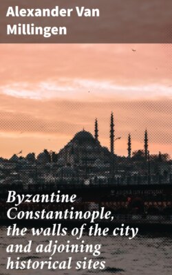
Map of Byzantine Constantinople. Drawn by F. R. von Hubner for and under the direction of Professor A. van Millingen.
(a) The Exokionion (τὸ ἐξωκιόνιον)[48] was a district immediately outside the Constantinian Wall, and obtained its name from a column in the district, bearing the statue of the founder of the city. Owing to a corruption of the name, the quarter was commonly known as the Hexakionion (τὸ ἑξακιόνιον).[49] It is celebrated in ecclesiastical history as the extra-mural suburb in which the Arians were allowed to hold their religious services, when Theodosius the Great, the champion of orthodoxy, prohibited heretical worship within the city.[50] Hence the terms Arians and Exokionitai became synonymous.[51] In later times the quarter was one of the fashionable parts of the city, containing many fine churches and handsome residences.[52]
Gyllius was disposed to place the Exokionion on the Fifth Hill,[53] basing his opinion on the fact that he found, when he first visited the city, a noble column standing on that hill, about half a mile to the north-west of the Mosque of Sultan Mehemet.[54]
Dr. Mordtmann, on the other hand, maintains that the designation was applied to the extra-mural territory along the whole line of the Constantinian land fortifications.[55]
But the evidence on the subject requires us to place the Exokionion on the Seventh Hill, and to restrict the name to that locality.
For in the account of the triumphal entry of Basil I. through the Golden Gate of the Theodosian Walls, the Exokionion is placed between the Sigma and the Xerolophos.[56] The Sigma appears in the history of the sedition which overthrew Michael V., (1042), and is described as situated above the Monastery of St. Mary Peribleptos.[57] Now, regarding the position of that monastery there is no doubt. The establishment, founded by Romanus Argyrus, was one of the most important monastic houses in Constantinople. Its church survived the Turkish Conquest, and remained in the hands of the Greeks until 1643, when Sultan Ibrahim granted it to the Armenian community.[58] Since that time the sacred edifice has twice been destroyed by fire, and is now rebuilt under the title of St. George. It is popularly known as Soulou Monastir (the Water Monastery), after its adjoining ancient cistern, and stands in the quarter of Psamathia, low down the southern slope of the Seventh Hill.
The Xerolophos was the name of the Seventh Hill in general,[59] but was sometimes applied, as in the case before us, to the Forum of Arcadius (Avret Bazaar) upon the hill’s summit.[60]
This being so, the Exokionion, which was situated between the Sigma and the Forum of Arcadius, must have occupied the upper western slope of the Seventh Hill.
In corroboration of this conclusion two additional facts may be cited. First, the Church of St. Mokius, the sanctuary accorded to the Arians for their extra-mural services in the Exokionion, stood on the Seventh Hill,[61] for it was on the road from the Sigma to the Forum of Arcadius,[62] and gave name to the large ancient cistern, the Tchoukour Bostan, to the north-west of the Forum.[63]
In the next place, the district on the Seventh Hill to the west of Avret Bazaar (Forum of Arcadius) and beside the cistern of Mokius, still retains the name Exokionion under a Turkish form, its actual name, Alti Mermer, the district of “the Six Columns,” being, evidently, the Turkish rendering of Hexakionion, the popular Byzantine alias of Exokionion.[64] The Exokionion, therefore, was on the Seventh Hill. Accordingly, the Wall of Constantine crossed that hill along a line to the east of the quarter of Alti Mermer.
(b) The next landmark, the Ancient Gate of the Forerunner (Παλαιὰ Πόρτα τοῦ Προδρόμου), elsewhere styled simply the Ancient Gate (Παλαιὰ Πόρτα),[65] furnishes the most precise indication we have of the position of Constantine’s wall. It was a gate which survived the original fortifications of the city, as Temple Bar outlived the wall of London, and became known in later days as the Ancient Gate, on account of its great antiquity. Its fuller designation, the Ancient Gate of the Forerunner,[66] is explained by the fact that a church dedicated to the Baptist was built against the adjoining wall. Conversely, the church was distinguished as the Church of the Forerunner at the Ancient Gate (τὴν Παλαιὰν).[67] Manuel Chrysolaras places the entrance to the west of the Forum of Arcadius, and describes it as one of the finest monuments in the city.[68] It was so wide and lofty that a tower or a full-rigged ship might pass through its portals. Upon the summit was a marble portico of dazzling whiteness, and before the entrance rose a column, once surmounted by a statue. When Bondelmontius visited the city, in 1422, the gate was still erect, and is marked on his map of Constantinople as Antiquissima Pulchra Porta.[69] It survived the Turkish Conquest, when it obtained the name of Isa Kapoussi (the Gate of Jesus), and held its place as late as 1508. In that year it was overthrown by a great earthquake. “Isa Kapoussi,” says the Turkish historian Solak Zadè, who records the occurrence, “near Avret Bazaar, which had been in existence for 1900 years (sic), fell and was levelled to the ground.”[70] But the shadow of the name still lingers about the site. A small mosque to the west of Avret Bazaar bears the name Isa Kapoussi Mesdjidi,[71] while the adjoining street is called Isa Kapoussi Sokaki. The mosque is an ancient Christian church, and probably bore in its earlier character a name which accounts for its Turkish appellation.
From these facts it is clear that the Wall of Constantine, in crossing the Seventh Hill, passed very near Isa Kapoussi Mesdjidi, a conclusion in accordance with the position already assigned to the Exokionion. The column outside the Ancient Gate was probably that which gave name to the district. Nowhere could a column bearing the statue of the city’s founder stand more appropriately than before this splendid entrance.
(c) Another landmark of the course of the Constantinian ramparts in this part of the city were the Trojan Porticoes (τρῳαδήσιοι ἔμβολοι),[72] which stood so near the wall that it was sometimes named after them, the Trojan wall (τῶν τειχῶν τῶν Τρῳαδησίων).[73]
From their situation in the Twelfth Region,[74] it is probable that they lined the street leading from the Porta Aurea into the city. They were evidently of some architectural importance, and are mentioned on more than one occasion as having been damaged by fire or earthquake.[75] The reason for their name is a matter of conjecture, and no trace of them remains.
(d) Nothing definite regarding the course of the Constantinian Wall can be inferred from the statement that it ran beside the Monastery of St. Dius and the Convent of Icasia, seeing the situation of these establishments cannot be determined more exactly than that they were found near each other, somewhere on the Seventh Hill.
The former, ascribed to the time of Theodosius I., is mentioned by Antony of Novgorod in close connection with the Church of St. Mokius and the Church of St. Luke.[76] The Convent of Icasia was founded by the beautiful and accomplished lady of that name,[77] whom the Emperor Theophilus declined to choose for his bride because she disputed the correctness of his ungracious remark that women were the source of evil.
(e) The Cistern of Aspar, which, according to the Paschal Chronicle,[78] was situated near the ancient city wall, is the old Byzantine reservoir (Tchoukour Bostan), on the right of the street conducting from the Mosque of Sultan Mehemet to the Gate of Adrianople in the Theodosian walls. This is clear from the following evidence. The cistern in question was a very large one, and stood near the Monastery of Manuel,[79] which was founded by the distinguished general of that name in the reign of Theophilus. The church of the monastery is now the Mosque Kefelè Mesdjidi in the quarter of Salmak Tombruk, and a little to the east of it stands the Tchoukour Bostan mentioned above,[80] the only large Byzantine reservoir in the neighbourhood.
This conclusion is again in harmony with the figures of Zosimus and the Notitia, which, it will be remembered, brought the line of the Constantinian Wall close to this point.
(f) The Cistern of Bonus, the next landmark to be considered, was built by the Patrician Bonus, celebrated in Byzantine history for his brave defence of the capital in 627 against the Avars and the Persians, while the Emperor Heraclius was in Persia carrying war into the enemy’s country.[81]
Where this cistern was situated is a matter of dispute which cannot be definitely settled in our present state of knowledge. Gyllius identified it with a large cistern, three hundred paces in length, which he found robbed of its roof and columns, and turned into a vegetable garden, near the ruins of the Church of St. John in Petra, on the Sixth Hill.[82] The cistern has disappeared since that traveller’s day, but as the Wall of Constantine never extended so far west, the identification cannot be correct.
In Dr. Mordtmann’s opinion, the Cistern of Bonus was the large open reservoir to the south-west of the Mosque of Sultan Selim, on the Fifth Hill,[83] and there is much to be said in favour of this view.
The Cistern of Bonus was, in the first place, situated in one of the coolest quarters of the city, and beside it, on that account, the Emperor Romanus I. erected a palace,[84] styled the New Palace of Bonus,[85] as a residence during the hot season. Nowhere in Constantinople could a cooler spot be found in summer than the terrace upon which the Mosque of Sultan Selim stands, not to speak of the attractions offered by the superb view of the Golden Horn from that point. Furthermore, the Cistern of Bonus was within a short distance from the Church of the Holy Apostles, seeing that on the eve of the annual service celebrated in that church in commemoration of Constantine the Great, the Imperial Court usually repaired to the Palace of Bonus, in order to be within easy riding distance of the sanctuary on the morning of the festival.[86] A palace near the reservoir beside the Mosque of Sultan Selim would be conveniently near the Church of the Holy Apostles, to suit the emperor on such an occasion. To these considerations can be added, first, the fact that on the way from the Palace of Bonus to the Church of the Apostles there was an old cistern converted into market gardens,[87] which may have been the reservoir near the Mosque of Sultan Selim; and, secondly, the fact that the Wall of Constantine, on its way from the Cistern of Aspar to the Golden Horn passed near the site now occupied by the Mosque of Sultan Selim, and, consequently, close to the old cistern adjoining that mosque. But to this identification there is a fatal objection: the Cistern of Bonus was roofed in,[88] whereas the reservoir beside the Mosque of Sultan Selim appears to have always been open.
Dr. Strzygowski has suggested that the Cistern of Bonus stood near Eski Ali Pasha Djamissi,[89] on the northern bank of the valley of the Lycus, and to the south-west of the Mosque of Sultan Mehemet.[90] No traces of a cistern have been found in that locality, but the conjecture satisfies the requirements of the case so far as the proximity of that site to the line of Constantine’s wall and to the Church of the Holy Apostles is concerned. Why that position should have been selected for a summer palace is, however, not apparent.
We have said that the Constantinian Wall, upon leaving the Cistern of Aspar, turned sharply to the north-east, and made for the shore of the Golden Horn by running obliquely across the ridge of the Fifth Hill.
This view of the case is required, first, in order to keep the breadth of the city within the limits assigned by the Notitia; and, secondly, by the statement of the same authority that the Eleventh Region—the Region at the north-western angle of the Constantinian city—did not extend to the shore of the Golden Horn: “Nulla parte mari sociata est.”[91] For this statement implies that the fortifications along the northern front of that Region stood at some distance from the water. But the northern slope of the Fifth Hill is so precipitous, and approaches so close to the Golden Horn that the only available ground for the fortifications on that side of the city would be the plateau of the Fifth Hill, where the large cistern beside the Mosque of Sultan Selim is found.
(g) The church dedicated to the three martyr brothers, SS. Manual, Sabel, and Ishmael, must likewise have been on the Fifth Hill; for it stood where the wall began its descent (κατήρχετο)[92] towards the Golden Horn. This agrees with the statement of the Synaxaria that the church was situated beside the land wall of Constantine, upon precipitous ground, and near the Church of St. Elias at the Petrion.[93]
(h) As to the district of Harmatius, named after Harmatius, a prominent personage in the reign of Zeno,[94] it must be sought in the plain bounded by the Fifth, Fourth, and Third Hills, and the Golden Horn, the plain known in later days as the Plateia, (Πλατεῖα). To that plain the fortifications of Constantine would necessarily descend from the Fifth Hill, in proceeding on their north-eastern course to the Golden Horn; and there also the figures of the Notitia require the northern end of the walls to terminate. Doubtless in the time of Constantine the bay at this point encroached upon the plain more than at present.
A church dedicated to St. Antony was found in this part of the city by the Archbishop of Novgorod, when he visited Constantinople at the close of the eleventh century. He reached it after paying his devotions in the Church of St. Theodosia, the Church of St. Isaiah, and the Church of St. Laurentius,[95] sanctuaries situated in the plain before us; the first being now the Mosque Gul Djami, near Aya Kapou,[96] while the two last are represented, it is supposed, respectively, by the Mosque of Sheik Mourad and the Mosque of Pour Kouyou, further to the south.[97] The Archbishop places the Church of St. Antony on higher ground than the Church of St. Laurentius, apparently a short distance up the slope of the Fourth Hill, a position which St. Antony of Harmatius may well have occupied.
(i) The locality known as the Zeugma, or Ferry of St. Antony, stood, naturally, beside the shore. If it cannot be identified with Oun-Kapan Kapoussi, where one of the principal ferries across the Golden Horn has always stood, it must, at all events, have been in that neighbourhood.
(j) With the result thus obtained regarding the course of the Constantinian Wall, may now be compared the statement of the Paschal Chronicle upon the subject. According to that authority the old land wall of the city crossed the promontory from the Gate of St. Æmilianus, upon the Sea of Marmora, to the district of the Petrion, upon the Golden Horn.[98] This statement is of great importance, because made while the wall was still standing; and it would on that account have been considered sooner, but for certain questions which it raises, and which can be answered more readily now than at a previous stage of our inquiries. The Chronicler makes the strange mistake of supposing that the wall which he saw stretching from sea to sea was the wall built originally for the defence of Byzantium by Phedalia, the wife of Byzas. Unfortunately, Byzantine archæologists were not always versed in history.
Setting aside, therefore, the Chronicler’s historical opinions, and attending to the facts under his personal observation, we find him entirely agreed with the Anonymus as regards the point at which the southern extremity of the Wall of Constantine terminated.
For the Gate of St. Æmilianus, by which the former authority marks that extremity, stood close to the Church of St. Mary Rabdou, the indication given by the latter.[99]
The case seems otherwise as regards the northern end of the line, for the Petrion, mentioned in the Paschal Chronicle, was, strictly speaking, the district in which the Greek Patriarchate is now situated, the name of the district being still retained by the gate (Petri Kapoussi) at the eastern end of the enclosure around the Patriarchal Church and residence. But this would bring the northern end of the land wall considerably more to the west than the point where we have reason to believe the Church of St. Antony was found. It would also make the city broader than the Notitia allows. The discrepancy can, however, be easily removed. For, while the Petrion was pre-eminently the district above indicated, the designation was applied also to territory much further to the east. The Church of St. Laurentius, for example, near which St. Antony’s stood, is at one time described as standing in the Plateia,[100] the plain to the east of Petri Kapoussi, while at another time it is spoken of as in the Petrion.[101] Hence the statement of the Paschal Chronicle does not conflict with what other authorities affirm respecting the point at which the Constantinian land fortifications reached the Golden Horn.
(k) Finally, from the Church of St. Antony the wall proceeded along the shore of the Golden Horn to the head of the promontory, thus completing the circuit of the fortifications.
It should, however, be noted that this work of surrounding the city with bulwarks was not executed entirely in the reign of Constantine. A portion of the undertaking—probably the walls defending the shores of the city—was left for his son and successor Constantius to complete.[102]
The following gates, mentioned in Byzantine history, were found, there is reason to believe, in the Constantinian circuit:—
Porta Polyandriou (Πόρτα Πολυανδρίου,[103] the Gate of the Cemetery) stood in the portion of the wall near the Church of the Holy Apostles. It is true that this was one of the names of the Gate of Adrianople in the later Theodosian Walls, but if the name was derived from the Imperial Cemetery beside the Church of the Holy Apostles, there is much probability in Dr. Mordtmann’s opinion that the designation belonged originally to the corresponding gate in the Constantinian fortifications, which stood closer to the cemetery.[104]
Another gate was the Porta Atalou (Πόρτα Ἀτάλου).[105] It was adorned with the statue of Constantine the Great and the statue of Atalus, after whom the gate was named. Both monuments fell in the earthquake of 740. The presence of the statue of the founder of the city upon the gate, the fact that the damage which the gate sustained in 740 is mentioned in close connection with the injuries done at the same time to the Column of Arcadius on the Xeropholos,[106] and the lack of any proof that the gate stood in the Theodosian Walls, are circumstances which favour the view that it was an entrance in the Wall of Constantine. From its association with the Xerolophos one would infer that the Gate of Atalus was situated on the Seventh Hill, in a position corresponding to one of the later Theodosian gates on that eminence.
That the Palaia Porta—Isa Kapoussi, beside the Mosque Isa Kapou Mesdjidi—was a Constantinian gate is beyond dispute.[107] But a difficult, and at the same time important, question occurs in connection with it. Was it the Porta Aurea mentioned in the Notitia as the gate from which the length of the city was measured? What renders this a difficult question is the fact that the Porta Aurea of the Theodosian Walls—the celebrated Golden Gate which appears so frequently in the history of the city, and which is now incorporated in the Turkish fortress of the Seven Towers (Yedi Koulè), under the name Yedi Koulè Kapoussi—was already in existence when the Notitia was written.[108] That being the case, the presumption is in favour of the opinion that the Golden Gate at Yedi Koulè is the Porta Aurea to which the Notitia refers; and this opinion has upon its side the great authority of Dr. Strzygowski.[109] On the other hand, the distance from the Porta Aurea to the sea, as given by the Notitia, does not correspond to the distance between Yedi Koulè and the head of the promontory, the latter distance being much greater. To suppose that this discrepancy is due to a mistake which has crept into the figures of the Notitia is possible; but the supposition is open to more than one objection. In the first place, such a view obliges us to assume a similar mistake in the figures which that authority gives for the breadth of the city, seeing they do not accord with the breadth of the city along the line of the Theodosian Walls. But even if this objection is waived, and the possibility of a double error admitted in the abstract, the hypothesis of a mistake in the figures before us is attended by another difficulty, which cannot be dismissed so easily. How comes it that figures condemned as inaccurate because they do not accord with the size of Constantinople under Theodosius II., prove perfectly correct when applied to the dimensions of the city under its founder? How come these figures to agree completely with what we learn regarding the length and breadth of the city of Constantine from other data on that subject? This cannot be an accident; the only satisfactory explanation is that the figures in question belonged to the primitive text of the document in which they are found, and never referred to anything else than the original size of the city. Hence we are compelled to adopt the view that when the Notitia was written, two gates bearing the epithet “Golden” existed in Constantinople, one of them in the older circuit of the city, the other in the later fortifications of Theodosius, and that the author of the Notitia refers to the earlier entrance. There is nothing strange in the existence of a Triumphal Gate in the Wall of Constantine, while the duplication of such an entrance for a later line of bulwarks was perfectly natural.
Why the Notitia overlooks the second Porta Aurea is explained by the point of view from which that work was written. Its author was concerned with the original city. A gate in the Wall of Theodosius was only the vestibule of the corresponding Constantinian entrance.
The existence of a Porta Aurea in the Wall of Constantine being thus established, the identification of that gate with the Palaia Porta offers little difficulty. The Constantinian Porta Aurea, like the Ancient Gate, stood on the Seventh Hill, since the portion of the Via Triumphalis leading from the Exokionion to the Forum of Arcadius was on that eminence.[110] Like the Ancient Gate, the Porta Aurea was, moreover, distinguished by fine architectural features, as its very epithet implies, and, as the Notitia declares, when it states that the city wall bounding the Twelfth Region, on the Seventh Hill, was remarkable for its monumental character—“Quam (regionem) mœnium sublimior decorat ornatus.”[111] Gates so similar in their position and appearance can scarcely have been different entrances.
Of the Constantinian gates along the seaboard of the city, the only one about which anything positive can be affirmed is the Gate of St. Æmilianus, near the Church of St. Mary Rabdou, on the Sea of Marmora. It is now represented by Daoud Pasha Kapoussi.[112]
Dr. Mordtmann[113] suggests the existence of a gate known as the Basilikè Porta beside the Golden Horn, where Ayasma Kapoussi stands; but this conjecture is exceedingly doubtful.
The Wall of Constantine formed the boundary and bulwark of the city for some eighty years, its great service being the protection of the new capital against the Visigoths, who asserted their power in the Balkan Peninsula during the latter part of the fourth century and the earlier portion of the fifth. After the terrible defeat of the Roman arms at Adrianople in 378, the Goths marched upon Constantinople, but soon retired, in view of the hopelessness of an attack upon the fortifications. The bold Alaric never dared to assail these walls; while Gainas, finding he could not carry them by surprise, broke up his camp at the Hebdomon, and withdrew to the interior of Thrace.
It is a mistake, however, to suppose that the original bulwarks of the capital were demolished as soon as the Theodosian Walls were built.[114] On the contrary, the old works continued for a considerable period to form an inner line of defence. We hear of them in the reign of Justinian the Great, when, together with the Wall of Theodosius, they were injured by a violent earthquake.[115] They were in their place also when the Paschal Chronicle was written.[116] What their condition precisely was in 740, when the Gate of Atalus was overthrown,[117] cannot be determined, but evidently they had not completely disappeared. Thereafter nothing more is heard of them, and the probability is that they were left to waste away gradually. Remains of ancient walls survived in the neighbourhood of Isa Kapoussi as late as the early part of this century.[118]