Читать книгу Dams, Displacement, and the Delusion of Development - Allen F. Isaacman - Страница 1
ОглавлениеDams, Displacement, and the Delusion of Development
Cahora Bassa and Its Legacies in Mozambique, 1965–2007
Allen F. Isaacman and Barbara S. Isaacman
We dedicate this book to the people of the lower Zambezi valley, whose lives have been forever altered by the Cahora Bassa Dam.
Acknowledgments
We began this project on Cahora Bassa in 1997, while conducting fieldwork for our book, Slavery and Beyond: The Making of Men and Chikunda Ethnic Identities in the Unstable World of South-Central Africa, 1750–1920. In the fifteen years we were working on this project, many friends and colleagues, through their intellectual insights and thoughtful critiques, helped us sharpen our arguments and avoid embarrassing errors.
We owe a special debt of gratitude to four scholars. Richard Beilfuss, who shared with us his vast knowledge of the ecology of the Zambezi Valley, was a generous and patient teacher. His influence is apparent in our numerous citations of his work and that of his colleagues. Arlindo Chilundo helped plan the initial phase of oral research, and, together with a team of students from the Universidade Eduardo Mondlane—Xavier Cadete, Germano Mausse Dimande, Eulésio Viegas Felipe, Paulo Lopes José, and António Tovela—participated with Allen in the fieldwork conducted in 2000 and 2001. The oral interviews collected in the lower Zambezi valley by this research brigade provided much of the data on which this study rests. Chilundo’s commitment to higher education in Mozambique prevented him from continuing on this project. Wapu Mulwafu, working with two students from the University of Malawi—John Mandala and Donald Khembo—and one from the Universidade Eduardo Mondlane—Xavier Cadete—interviewed peasants living near the confluence of the Zambezi and Shire Rivers in 2000. Their research provided valuable insights about the social, ecological, and cultural effects of Cahora Bassa in that region. Finally, David Morton interviewed farmers living near Mponda Nkuwa, the site of a proposed new dam downriver from Cahora Bassa.
When we began this project, we knew very little about the construction and far-reaching consequences of large dams. Besides Richard Beilfuss, we were extremely fortunate to consult with and learn from Carlos Bento, Bryan Davies, Leila Harris, Patrick McCully, Lori Pottinger, Daniel Ribeiro, Thayer Scudder, and Chris Sneddon. Together, they patiently answered our questions and identified critical bodies of literature for us to consult.
A number of scholars read various drafts of our manuscript. The final product is far better, thanks to the detailed comments of Heidi Gengenbach, Leila Harris, Jim Johnson, Premesh Lalu, Elias Mandala, Stephan Miescher, David Morton, and Derek Peterson. Portions of this project were presented as lectures and seminars at the Center for Advanced Studies in the Behavioral Sciences (Stanford University); Colgate University; Cornell University; the Rockefeller Study and Conference Center (Bellagio); the Universidade Eduardo Mondlane; the University of California, Santa Barbara; the University of Michigan; the University of Minnesota; and the University of the Western Cape. Participants and audience members at all of these institutions, including James Campbell, Laura Fair, Jim Ferguson, M. J. Maynes, Anne Pitcher, Helena Pohlandt-McCormick, Daniel Posner, Arvind Rajagopal, Anupama Rao, Ciraj Rasool, Richard Roberts, Abdi Samatar, Joel Samoff, Eric Sheppard, Ajay Skaria, France Winddance Twine, and Eric Worby, offered critiques and suggestions that helped us sharpen our thinking. Finally, we commend Jean Allman, coeditor of the Ohio University New African Histories series, for her thoughtful and supportive comments. It was a pleasure to work with her and Gillian Berchowitz, the editorial director at Ohio University Press.
The staff of the Arquivo Histórico de Moçambique, the Arquivo Nacional da Torre do Tombo, and the Hoover Institution always happily assisted us. We are also grateful to the International Rivers Network and Justiça Ambiental for sharing their considerable holdings on Cahora Bassa.
We wish to thank the American Council of Learned Societies, the Center for Advanced Studies in the Behavioral Sciences, the Rockefeller Foundation (Bellagio), and the University of Minnesota for their generous support. The idyllic conditions at the Center make it the perfect place to work on a manuscript, and there is no better ambiance in which to complete such a project than Bellagio. We also received the assistance of the Cartography Laboratory at the University of Minnesota, whose maps grace our book.
Finally, we owe an incalculable debt to the hundreds of men and women—peasants, fisherfolk and dam workers—who readily shared their memories, experiences, and perspectives. They were our best teachers, and we hope that we have done justice to their stories. It is to them that we dedicate this book.
Abbreviations
AIM Agência de Informação de Moçambique (Mozambique Information Agency)
ANC African National Congress
EDM Electricidade de Moçambique (Mozambique’s public electricity utility)
Eskom Electricity Supply Commission (South Africa’s public electricity utility)
FIVAS Foreningen for Internasjonale Vannstudier (Association for International Water Studies)
Frelimo Frente de Libertação de Moçambique (Mozambican Liberation Front)
GPZ Gabinete do Plano do Zambeze (Zambezi Valley Planning Office)
HCB Hidroeléctrica de Cabora Bassa (Cabora Bassa Hydroelectric)
IMF International Monetary Fund
JA! Justiça Ambiental
MFPZ Missão de Fomento e Povoamento de Zambeze (Mission for the Promotion and Development of the Zambezi)
PIDE Polícia Internacional e de Defesa do Estado (International and State Defense Police)
Renamo Resistência Nacional Moçambicana (Mozambican National Resistance)
UTIP Unidade Técnica de Implementação dos Projectos Hidroeléctricos (Technical Unit for Implementation of Hydropower Projects)
WCD World Commission on Dams
WNLA Witwatersrand Native Labour Association
Zamco Zambeze Consórcio Hidroeléctrico Lda. (consortium that built Cahora Bassa)
ZANU Zimbabwe African National Union
ZAPU Zimbabwe African People’s Union
ZESA Zimbabwe Electricity Supply Authority
Abbreviations in Notes
ACL Academia das Ciências de Lisboa
AHD Arquivo Histórico Diplomático de Ministério dos Negócios Estrangeiros
AHM Arquivo Histórico de Moçambique
AHU Arquivo Histórico Ultramarino
ANTT Arquivo Nacional da Torre do Tombo
BPA Biblioteca Pública de Ajuda
DGS Direcção Geral de Segurança (General Security Directorate; successor to PIDE)
DM David Morton
GG Governo Geral
GPZ Gabinete do Plano do Zambeze
HCB Hidroeléctrica de Cabora Bassa (Cabora Bassa Hydroelectric)
HIA Hoover Institution Archives, Stanford University
HMK Hidroeléctrica de Mphanda Nkuwa
MC Middlemas Collection, Hoover Institution Archives, Stanford University
MFPZ Missão do Fomento e Povoamento do Zambeze
MNR Mozambique National Resistance
MRB Muwalfu Research Brigade (University of Malawi)
MRME Ministério dos Recursos Minerais e Energia (Ministry of Mineral Resources and Energy)
PIDE Polícia Internacional e de Defesa do Estado (International and State Defense Police)
SC Secção Confidencial
SCCIM Serviços de Centralização e Coordenação de Informações de Moçambique (Centralized Services for Coordination of Information from Mozambique)
T/A Traditional Authority
UTIP Unidade Técnica de Implementação dos Projectos Hidroeléctricos
WCD World Commission on Dams
Archival Terms
caixa box
códice codex
fol. folio
maço packet
pasta folder
processo file
Unless otherwise indicated, all interviews have been conducted by the authors or by a research team of which one of the authors was a part.
Cahora Bassa Timeline
May 1956 The Salazar regime dispatches Professor Alberto Manzanares to conduct a preliminary survey of the Cahora Bassa gorge.
September 1969 Lisbon signs a $515 million agreement with Zamco for it to build the Cahora Bassa Dam.
September 7, 1974 Frelimo and Portugal sign the Lusaka peace accord, which set the terms for the eventual transfer of the Cahora Bassa Dam to Mozambique.
December 6, 1974 The dam’s gates close, blocking the Zambezi River from flowing freely downstream to the Indian Ocean.
April 1975 The reservoir at Cahora Bassa is filled, forming a 2,600-square-kilometer lake.
June 23, 1975 Portugal and Mozambique sign the agreement giving the HCB 82 percent ownership of the Cahora Bassa Dam.
June 25, 1975 Mozambique formally becomes independent.
January 1987 Mozambique implements the structural adjustment program known as the Program of Economic Rehabilitation (PRE).
October 4, 1992 The Mozambican government signs a peace accord with Renamo in Rome.
May 2002 The Mozambican government holds an investors’ conference, seeking bids for the construction of the Mphanda Nkuwa hydroelectric project.
November 27, 2007 Mozambique purchases majority ownership of Cahora Bassa from the HCB.
2014 It is anticipated that Mozambique will own 100 percent of the dam by then.
1 Introduction
Cahora Bassa in Broader Perspective
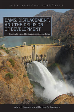
Dams have histories that are located in specific fields of power. Unlike the dams themselves, however, these histories are never fixed; whether celebrated or contested, they are always subject to reinvention by state and interstate actors, corporate interests, development experts, rural dwellers, and academics. Too often, though, the viewpoints of people displaced to make room for a dam are lost or silenced by the efforts of the powerful to construct its meaning in narrow terms of developmental or technical success. Yet, the voices of the displaced endure, carried by memories as powerful as the river itself. Such is the case of Cahora Bassa,1a grandiose dam project on the Zambezi River in Mozambique (see maps 1.1 and 1.2).
The Zambezi River is the fourth-largest waterway in Africa and the largest river system flowing into the Indian Ocean. Although the Cahora Bassa Dam and reservoir are entirely inside Mozambique, the vast bulk of its drainage basin lies outside the country. “Rising in Angola it has a catchment area of 1,570,000 [square kilometers], drains the southern borders of the Democratic Republic of Congo (DRC) and traverses Botswana, Zambia, Zimbabwe, Tanzania, Malawi and Moçambique.”2Because Mozambique is furthest downstream, it depends on its neighbors for access to the Zambezi’s waters.
Before the Zambezi or any of its tributaries were dammed by the Europeans in the twentieth century, the rate of the river’s flow varied considerably in the catchment area. In much of the basin, located on the Central African plateau (termed the upper Zambezi by hydrologists), the water moved slowly through low plains and swamps. The undulating topography changed radically at Victoria Falls, where the river plunged more than one hundred meters and became the middle Zambezi. It was on this stretch, downstream from Victoria Falls, that the British built Kariba Dam in 1958. Approximately one hundred kilometers further downstream, at the Cahora Bassa gorge, the river plunged once again, down a long succession of rapids and cascades, turning into a powerful and volatile force. The gorge marked the beginning of the lower Zambezi, which extended 650 kilometers to the Indian Ocean. Drawing from the British experience at Kariba, colonial planners decided that Cahora Bassa would be an ideal location for Portugal’s hydroelectric project.3
When built, in the early 1970s, during the final years of Portuguese colonial rule, Cahora Bassa attracted considerable international attention. Engineers and hydrologists praised its technical complexity and the skill required to construct what was then the world’s fifth-largest dam. For them, Cahora Bassa confirmed that nature could be conquered and biophysical systems transformed to serve the needs of humankind. Portuguese colonial officials recited a litany of benefits they expected from the $515 million megadam and the managed environment it would produce—expansion of irrigated farming, European settlement, and mineral output; improved communication and transportation throughout the Zambezi River valley; reduced flooding in this zone of unpredictable and sometimes excessive rainfall. In slick brochures and public pronouncements, they claimed that Cahora Bassa would “foster human progress through an improved standard of living for thousands of Africans who live and work there.”4Above all, Cahora Bassa would generate a substantial influx of hard currency, since 82 percent of its electricity would go to South Africa—making it the largest dam in the world producing energy mainly for export. As a follow-up to this technological triumph, Portuguese planners envisioned building a second dam, sixty kilometers south of Cahora Bassa, at Mphanda Nkuwa (see map 1.3).
In June 1975, six months after the dam’s completion, Mozambique gained its independence, ending a decade of warfare between the colonial regime and the guerrilla forces of Frelimo (Frente de Libertação de Moçambique). The newly installed Frelimo government—after years of claiming that Cahora Bassa, by providing cheap energy to apartheid South Africa, would perpetuate white rule throughout the region—radically changed its position. Hailing the dam’s liberating potential, it expressed confidence that Cahora Bassa would play a critical role in Mozambique’s socialist revolution and its quest for economic development and prosperity.
Even after Frelimo abandoned its socialist agenda, in 1987,5the dam remained central to Mozambique’s postcolonial development strategy. Serious economic problems, stemming in part from the ongoing military conflict with South African–backed Renamo forces6 and mounting pressure from the International Monetary Fund (IMF) and the World Bank, compelled the Mozambican government to introduce market-oriented reforms to lure foreign investment. What did not change was its continued celebration of the transformative potential of Cahora Bassa, whose provision of cheap electricity to new privately owned plants and factories would stimulate rapid industrial growth. Moreover, its announced intention, in the late 1990s, to implement the colonial plan to build a second dam at Mphanda Nkuwa underscored Frelimo’s belief that large energy-producing dams were essential for national economic development.
Thus, despite their very different economic agendas and ideological orientations, the Portuguese colonial regime, the postindependence socialist state, and its free-market successor all heralded the developmental promise of Cahora Bassa. Whether Portuguese or Africans held the reins of state power, the dam symbolized the ability of science and technology to master nature and ensure human progress.7Moreover, to the extent that official versions of Cahora Bassa’s history became the dominant reading of the past, they suppressed alternative voices that questioned the state’s interpretive authority.8
The African communities living along the Zambezi River, however, tell a markedly different story. When the three hundred Zambezi valley residents interviewed for this book speak of the dam, their accounts rarely evoke images of prosperity or progress. Instead, Cahora Bassa evokes memories of forcible eviction from historic homelands, of concentration in crowded resettlement camps, and of unpredictable discharges of water that destroyed their crops and flooded their fields. Many also describe in detail the results of the river’s altered flow regime—the devastating erosion of fertile riverbanks, the destruction of wildlife vital to their food security, and the dramatic decline of fish populations.
This book advances three central arguments. First, over the past three and one-half decades, Cahora Bassa has caused very real ecological, economic, and social trauma for Zambezi valley residents. All this is conspicuously absent from the widely publicized developmentalist narratives of Mozambique’s colonial and postcolonial states, which have been a critical feature of state efforts to dam the Zambezi River in Mozambique. Elderly African peasants,9who had a long and intimate relationship with the Zambezi River, graphically describe how the dam devastatingly affected their physical and social world and recount their resiliency in coping and adjusting. These memories, which speak so powerfully about the daily lives and lived experiences of the rural poor, are either discounted or ignored in dominant discourses touting Cahora Bassa’s centrality to national development. This silencing is indicative of the unequal field of power in which the histories of the rural poor are typically embedded.
The second argument is that extreme and continual violence has been a critical feature of state efforts to dam the Zambezi River in Mozambique. Bluntly stated, the history of Cahora Bassa reveals the willingness of an authoritarian but embattled colonial state, facing an armed nationalist movement and mounting criticism from the outside world, to put the full weight of its coercive power behind economic and strategic objectives it believed would strengthen its permanent hold over Mozambique. The forced labor used to build the roads to the dam site, the harsh labor regime at the dam itself, the displacement of thousands of peasants, and Renamo’s prolonged destabilization campaign demonstrate the extent to which violence is deeply implicated in the history of Cahora Bassa.
The deleterious social and ecological consequences of this massive state-imposed project never figured in the political calculus of colonial planners. Nor do they seem to matter in current discussions about the building of a second dam, at Mphanda Nkuwa. This disregard for peasants’ concerns about Mphanda Nkuwa is yet another example of the state’s continuing efforts to silence the voices of the rural poor—a form of epistemic violence. In this respect, the present neoliberal government mimics the ways in which the late colonial state exercised and rationalized power.10
The history of Cahora Bassa also reveals the persistence of “colonialism’s afterlife.”11Under the 1974 Lusaka peace accord, which set the stage for Mozambique’s independence, in return for assuming the $550 million debt incurred in building Cahora Bassa, Hidroeléctrica de Cabora Bassa (HCB), a Portuguese parastatal, received 82 percent of the shares, with the remainder going to the Mozambican government. The Constitution of the Cahora Bassa Dam, signed between Portugal and Frelimo on June 23, 1975, which memorialized this agreement, granted the HCB the right to manage the dam until Mozambique repaid the construction debt.12Because it was unable to do so until 2007, for thirty-two years after independence a Portuguese company retained effective control of the hydroelectric project (see chapter 6)—operating the dam, determining the outflows of water, and negotiating the sale of virtually all its electricity to South Africa.
That the newly independent socialist government could not use this energy for domestic purposes, such as electrifying the countryside, exposed the neocolonial reality—which persisted even after Frelimo adopted a neoliberal agenda in 1987 and needed cheap energy from Cahora Bassa to attract foreign investments and promote a free-market economy. Throughout, HCB management ignored these needs. For Mozambicans, Cahora Bassa was a living symbol of the violent and oppressive past and a constant reminder that independence did not guarantee resource sovereignty.13
In the mid-1990s, Frelimo began a campaign to wrest control of Cahora Bassa and its energy from Portugal. Lisbon, however, summarily rejected all Mozambique’s attempts to reduce or erase the price it would have to pay to own the dam. To enhance its bargaining power, the Mozambican government then threatened to revive a colonial plan to build a second dam downriver at Mphanda Nkuwa, which would reduce Cahora Bassa’s profitability. In 2007, under increasing pressure from Mozambique and its postapartheid South African ally, Portugal finally agreed to sell two-thirds of its shares in Cahora Bassa for $700 million (see chapter 6).
By this time, the Mozambican government had decided that two dams on the Zambezi were better than one, despite the human suffering and ecological destruction Cahora Bassa had inflicted. The rationale for constructing another dam at Mphanda Nkuwa was, as before, that foreign exchange would come from the sale of its energy—to South Africa and other energy-starved nations in the region. Rural electrification remained a secondary consideration, notwithstanding that only 7 percent of Mozambican households had access to electricity. In this regard, postindependence Mozambique continued the colonial ways of seeing, thinking, and acting. The persistent links between the postcolonial present and the colonial past is the third argument we advance.
We first became interested in the history of Cahora Bassa in 1997, when we visited Songo, the town adjacent to the dam site, to attend a Ministry of Culture–sponsored conference about the dam.14The list of participants was impressive. It included the manager of Cahora Bassa, who recounted the engineering feat of the dam’s construction and the valiant attempts to keep it functioning, despite repeated Renamo attacks. Prominent scientists provided richly detailed accounts of the effects of the postdam river flow regime on the flora and fauna of the lower Zambezi valley. Historians presented papers on topics ranging from changing Zambezi flood patterns to the political economy of the dam. While more than fifty experts participated in the Songo colloquium,15absent were the voices of the African workers whose labor actually built Cahora Bassa and of the rural poor whose lives it changed forever—except through the presentations of a few sympathetic Europeans, who could offer, at best, only partial renditions of what local people remembered of the dam’s history.16We quickly realized how little we knew about its impact on Songo-area workers and peasants, not to mention the rural communities downriver, whose gardens and grazing lands no longer benefited from the Zambezi’s seasonal irrigation and whose fishing lagoons Cahora Bassa had greatly reduced.
This study presents an alternative history of Cahora Bassa—one that seeks to recover, or bring to the surface, what the master narratives of Mozambique’s colonial and postcolonial state actors have suppressed.17This version clearly demonstrates that human and environmental well-being are inextricably intertwined, that development projects cannot be separated from the politics of control over scarce resources, and that the critical question of what is being “developed”—and for whom—is shaped as much by transnational as national or local actors.
Environmental policies and practices can never be divorced from relations of power. This is especially true when what is at stake is control over water, since no other natural resource is more important for the maintenance of life, society, and stable government. It is no surprise, then, that control of aquatic resources has provoked, and continues to provoke, conflict at local and national levels in Mozambique and elsewhere, especially in the global South.18
In the final analysis, most large state-driven development projects—whether dams or other initiatives that facilitate resource extraction and the export of cheap commodities—have not only failed to alleviate poverty and promote sustainable livelihoods but also often imperiled the lives of the poor. As long as such planned interventions lead to growing disparities in wealth and concomitant increases in hunger and poverty, which are the natural consequences of their market-driven calculus, for the overwhelming majority of people living in the global South there remains nothing but the delusion of development.
The Dam Revolution in Africa
In the second half of the twentieth century, worldwide construction of large dams19 increased exponentially—from approximately five thousand by 1950 to over fifty thousand by 2000.20According to Professor Kader Asmal, chair of the World Commission on Dams (WCD), “We dammed half our world’s rivers at unprecedented rates of one per hour, and at unprecendented scales of over 45,000 [large] dams.”21As a result, dam reservoirs submerged more than four hundred thousand square kilometers of the world’s most fertile land.22Although the pace of construction has slowed, a number of new dams—most notably China’s Three Gorges—were erected in the first decade of the twenty-first century.
In his monumental study of dams, Patrick McCully describes the appeal of such projects for political leaders as different as Jawaharlal Nehru, Mao Tse-tung, Franklin Roosevelt, and Joseph Stalin: “The gargantuan scale of large dams, and their seeming ability to bring powerful and capricious natural forces under human control, gives them a unique hold on the human imagination. Perhaps more than any other technology, massive dams symbolize the progress of humanity from a life ruled by nature and superstition to one where nature is ruled by science, and superstition vanquished by rationality.”23Nehru, for instance, invoked a sense of national pride, when observing the 226-meter-high Bhakra Dam, in northern India: “What a stupendous, magnificent work—a work which only that nation can take up which has faith and boldness!”24
The international community provided both material and moral support for these megaprojects. The World Bank, the largest financier of dams, funded more than six hundred dam projects in ninety-three countries during this period.25Other major lenders included the Inter-American and Asian Development Banks.26The Agricultural Organization of the United Nations (FAO) and the UN Development Programme (UNDP) also financed dam construction, as did the United States Agency for International Development (USAID) and the British Overseas Development Administration (ODA).27
These dam proponents, however, uniformly ignored the fact that the construction of large dams also brought intense suffering for an estimated 30 to 60 million people worldwide—many already poor and disenfranchised.28Most large dams forced poor rural populations to abandon their historic homelands, which the river’s displaced water then submerged. In several cases, dams even had lethal consequences—the most tragic, perhaps, occurring in China’s Hunan Province, where a number of dam bursts in 1975 left more than two hundred thousand people dead.29
Africa, too, became part of the dam revolution. In the name of modernization and prosperity, especially in the developmentalist years after World War II, European colonial governments constructed major hydroelectric complexes—as well as other large infrastructural projects.30Ghana’s Akosombo Dam, for example, although originally conceived in the late colonial period, was erected under the leadership of Kwame Nkrumah shortly after independence.31Nkrumah used the language of national development to explain his unequivocal support for this colonial project: “Newer nations, such as ours, which are determined by every possible means to catch up in industrial strength, must have electricity in abundance before they can expect any large-scale industrial advance. . . . That, basically, is the justification for the Volta River Project.”32
African leaders of all political persuasions embraced these projects with unbridled enthusiasm, as did their postcolonial successors. After all, dams reinforced the consolidation of state power in the countryside and were highly visible symbols of modernity and development. During the second half of the twentieth century, African governments constructed more than one thousand dams, including twenty megaprojects such as the Akasombo Dam in Ghana, the Lagdo Dam in Cameroon, the Kainji and Bakolori Dams in Nigeria, the Kossou Dam in Ivory Coast, and the Masinga Dam in Tanzania. Some of the most highly publicized dams in Africa—the Aswan High Dam, the Kariba Dam, and the Lesotho Highlands Water Project—cut across territorial frontiers.33By the end of the twentieth century, South Africa alone had more than 550 dams in operation.34
As elsewhere, the construction of large dams in Africa often had deleterious consequences. Megadams at Akasombo, Aswan, and Kariba flooded hundreds of thousands of hectares of fertile farmland.35The Akasombo, for example, which permanently inundated 4 percent of Ghana’s land area, forced more than eighty thousand Ghanaians to abandon their communities adjacent to the Volta River.36Similarly, the Aswan dam uprooted one hundred twenty thousand people in Egypt and Sudan, and, in the area of the Kariba Dam, fifty-seven thousand Gwembe Tonga lost their homelands.37In these and many other cases around the continent, the physical, social, and cultural worlds of displaced peoples turned upside down.
People located downriver from the dams also found their livelihoods in jeopardy and critical natural resources degraded.38Damming permanently altered a river’s flow regime—particularly the timing and extent of flooding along its banks. This disruption jeopardized long-established agricultural production systems that depended on seasonal flooding to enrich alluvial soils.39It also destroyed downriver fishing industries, increased waterborne diseases, eroded the shoreline and coast, degraded aquatic ecosystems, and caused declines in riparian animal and plant life.40Among the conclusions of a highly influential 2000 report by the WCD was the recognition that “in too many cases an unacceptable and often unnecessary price has been paid to secure these benefits [of dams], especially in social and environmental terms, by people displaced, by communities downstream, by taxpayers and by the natural environment.”41Rural Mozambicans living adjacent to the Zambezi River certainly paid that price.
Although the construction of Cahora Bassa shares much in common with hydroelectric projects elsewhere in both Africa and other regions of the global South, the political context and social dynamics of Mozambique’s megadam were unique. Cahora Bassa was the last “great” colonial infrastructure project in Africa. Whereas post–World War II British and French colonial planners tried to reshape the rural landscape of their African possessions through far-reaching river basin schemes and other large development projects,42Portuguese authorities invested little in Mozambique’s rural infrastructure—or those of its other African colonies of Angola, Guinea-Bissau, and São Tomé. That all changed in the early 1960s when Portugal, as part of its antiguerrilla policy, began a number of infrastructural projects in the central and northern regions of the colony.
Military exigencies also explain why Cahora Bassa has the dubious status of being the world’s largest national hydroelectric project created to export energy.43Mozambique’s megadam, which cost so many rural families their livelihoods, land, and homes, existed solely to cement military ties between the Portuguese colonial administration and its apartheid neighbor, by exporting cheap energy to South Africa. In the process, the Mozambican countryside—even areas adjacent to the dam site—remained in the dark.
While the construction of large dams in Africa and elsewhere involved the forcible relocation by the state of large numbers of indigenous people, only in Mozambique were the victims of relocation herded into barbed-wire encampments (aldeamentos) to prevent them from aiding Frelimo guerrillas. The government also forcibly evicted several thousand more Africans living on the salubrious highlands near the dam site to make room for the construction of a segregated town for white workers and their families.
But it was not only peasants who suffered. Local African men who were conscripted to build the roads leading to the dam experienced another form of violence for the sake of Cahora Bassa, and the dam itself was literally built on the backs of thousands of African laborers enmeshed in a coercive and highly regimented labor regime.
These harsh realities highlight the central role of violence as a defining feature of Cahora Bassa’s history. Unlike in India and Brazil, for instance, where domestic struggles shaped the politics of dam construction,44in Mozambique external political and security considerations generated this violence. Because the hydroelectric project symbolized the military alliance between the Portuguese colonial state and apartheid South Africa, the surrounding region became a highly contested zone of confrontation between Frelimo guerrillas seeking to sabotage it and the Portuguese military, which, with logistical support from Pretoria, unleashed a wave of violence against the peasant population allegedly to prevent them from aiding Frelimo.
Even after both the dam’s completion and Mozambique’s independence, the violence continued. When South African–backed Renamo forces launched a military campaign to destroy the new nation’s economic infrastructure, Cahora Bassa’s power lines were inviting targets—since the apartheid economy did not require the energy at that moment. These attacks lasted for over fifteen years.
The Literature on Large Dams
The dam revolution generated a voluminous body of scholarly literature, detailed discussion of which falls outside of the scope of this study. Broadly speaking, there are two diametrically opposed schools of thought: one celebrating and promoting these megaprojects as developmentalist triumphs and the other highlighting their damaging social and environmental consequences.
Engineers, economists, development experts, state officials, and representatives of the dam industry have been the most vocal proponents of the celebratory school. Their influential publications date back to the completion of the Hoover Dam, in the 1930s.45For half a century thereafter, they controlled the terms of public debate, while promoting dams in all corners of the globe. Using a narrow cost-benefit analysis, they emphasized the transformative potential of hydroelectric projects, even while acknowledging some of their unintended negative consequences. Dams, they stressed, provided a source of cheap energy that would stimulate industrial production and electrify areas with no previous access to power. Harnessing rivers, in their view, would promote irrigation and flood control, facilitate river transport, and ensure a secure supply of clean water. Many also predicted a sharp increase in the number of fish in dam reservoirs, thereby increasing the potential income of commercial anglers. More recently, the dam industry and its allies have appropriated the discourse of the green energy movement to claim that hydroelectric projects are a cleaner source of fuel than coal, thermal, oil, or natural gas.46
In the 1970s, geographers and anthropologists concerned about the social costs of dislocation and the worrisome environmental effects of recently erected dams began to challenge this dominant narrative. They pointed to the devastating ecological and health consequences of a river’s inability to flow freely, since large dam reservoirs flooded fertile farmlands and rich forests, drowned wildlife, and destroyed medicinal plants. Downriver, altered flow regimes increased erosion, destroyed subsidiary channels, disrupted fish populations, increased salinization, and threatened vital mangrove forests. Human populations occupying river valleys also suffered sharp spikes in waterborne diseases, such as schistosomiasis, malaria, and gastroenteritis.47
Mounting evidence of large dams’ damaging effects helped fuel indigenous protest movements, particularly in Brazil, India, Nigeria, Thailand, Turkey, and Zambia, and added urgency to academic debates.48These local insurgencies, supported by a growing transnational antidam movement,49highlighted for the world the traumatic social and cultural costs to riverine communities. Concerned scholars followed the lead of antidam activists, publishing accounts of forced displacement and the ways in which postdam flow regimes undermined traditional agricultural systems.50Other academics questioned whether providing cheap energy for cities and export industries at the expense of the rural poor was a sustainable development strategy or simply a reflection of who controlled the levers of state power.51
Although most of these debates focused on large dams in Asia and Latin America, Africanist scholars contributed by challenging the “heroic and often arrogant, modernizing dam-building agenda of the 1960s to the 1980s.”52Foremost among them was the eminent anthropologist Elizabeth Colson, whose foundational 1971 study The Social Consequences of Resettlement, based on her extensive fieldwork in the 1960s, described in painful detail how the world of more than fifty-seven thousand Gwembe Tonga was turned upside down by their forcible removal from their homelands in southern Zambia during construction of the Kariba Dam. Thayer Scudder, who worked with Colson, extended her analysis by publicizing the dam-induced poverty in the area surrounding Lake Kariba, one of the largest artificial lakes and reservoirs in the world.53Geographer William Adams, in his continentwide study, Wasting the Rain, documented how river development schemes disrupted floodplain ecologies and subverted farming and fishing.54Most recently, feminist scholar Dzodzi Tsikata’s Living in the Shadow of the Large Dams analyzed the experiences of lakeside and downstream communities affected by Ghana’s Volta River Project.
Other Africanists, both north and south of the Sahara, opened up new areas of inquiry. Timothy Mitchell’s provocative Rule of Experts, using the case of the Aswan High Dam to explore the inner world of technopolitics in the Egyptian state, showed how colonial and postcolonial experts celebrated the transformative power of dams while sidelining peasants’ concerns.55JoAnn McGregor’s innovative study, Crossing the Zambezi, situated the Kariba Dam’s construction within the 150-year history of the politics of landscape in the middle Zambezi, while Julia Tischler’s doctoral dissertation on Kariba analyzed the politics of development in the turbulent era of decolonialization.56Tsikata’s work on the Volta Dam raised important questions about the gendered effects of Africa’s hydroelectric projects, and Stephan Miescher’s current research, extending the analysis beyond political economy and ecology, will explore its cultural symbolism and Ghanaian attitudes toward modernity, development, and nationhood.57
Our work is informed by both the scholarly debate on Africa’s large dams and prior scholarship on Cahora Bassa, much of which focused on either the dam’s strategic dimensions or its effects on downriver flora and fauna. João Paulo Borges Coelho’s 1993 doctoral thesis, “Protected Villages and Communal Villages in the Mozambican Province of Tete (1968–1982),” detailed how the forced relocation of thousands of peasants—both those living in the area adjacent to Cahora Bassa and others residing in adjacent regions not affected by the dam—was a critical dimension of Lisbon’s counterinsurgency progam.58Keith Middlemas’s 1975 study, Cabora Bassa: Engineering and Politics in Southern Africa, documented the challenges of financing and constructing the dam, drawing on official government reports, correspondence between Lisbon and prospective investors, and over one hundred interviews with dam officials, African workers, Portuguese military commanders, and Frelimo guerrillas.59In his carefully researched doctoral thesis, “The Regulation of the Zambezi in Mozambique,” Peter Bolton examined the initial impact of the dam on the Zambezi River valley.60
Professor Brian Davies, a University of Cape Town zoologist, was part of a Portuguese research team in the 1970s investigating the anticipated ecological impacts of Cahora Bassa. After conducting pioneering studies downriver, he predicted that the dam would cause appreciable environmental destruction.61He spent the next thirty years mapping out the actual consequences, which were even worse than what he had predicted.62His work has been extended by Richard Beilfuss, a hydrologist who, with a team of Mozambican and foreign scientists, extensively researched environmental flows and sustainable management of the Zambezi River over the last two decades.63Their extremely important studies of wetland and wildlife conservation, particularly in the Zambezi delta, have provided invaluable information on the long-term ecological effects of Cahora Bassa. Our debt to all these scholars, but particularly to Beilfuss and his colleagues, is evident in the frequency with which we cite their work.
The present study makes three contributions to the literature on Cahora Bassa and the broader scholarship on the impact of large hydroelectric projects in Africa and the global South. Most writings on large dams have a strong presentist bias. Investigators typically begin their analyses either just before a dam’s construction or shortly thereafter. By contrast, we treat Cahora Bassa as part of a much longer history, dating back to the sixteenth century, of Portuguese attempts to colonize the Zambezi valley and domesticate one of Africa’s mightiest rivers. In summarizing that history, we also explore how European travelers and Portuguese functionaries forged a master narrative of the river as wild and dangerous—one that stands in stark contrast to indigenous representations of the Zambezi as a source of life and prosperity, which could be dangerous if not respected. Additionally, we look ahead—examining how the dam’s history may affect Mozambique’s decision to build a second dam at Mphanda Nkuwa, sixty kilometers downriver.
Just as we have extended the temporal parameters of our study beyond the relatively short history of the Cahora Bassa Dam, so too have we broadened its spatial dimensions by extending our gaze downriver from the dam site and reservoir to the Zambezi delta and estuary. Most studies of large dams tend to explore the social and ecological consequences either around the dam site or in the river delta, rather than examining the entire river system. As part of this expanded geographic perspective, we also include material on the Kariba Dam, located approximately eight hundred kilometers upriver on the Zimbabwe-Zambia border, since the amount of water it discharged has had a significant impact on Cahora Bassa and the area downriver. To understand the changing fields of power in which Cahora Bassa’s history is embedded, it is necessary to consider the wider regional, transnational, and global forces operating during this period. Cold war geopolitics, the apartheid regime’s aggressive efforts at bolstering its hegemonic position in the region, Lisbon’s efforts to maintain a significant presence in postcolonial Mozambique, and pressure from the World Bank and the IMF have all figured prominently in the history of the dam.
Finally, we have shifted our principal angle of vision from a state-centric developmental approach to one that explores the linkages between power inequities and environmental change—particularly the difficulties of securing water for the Zambezi valley’s rural poor and ecosystems. We focus on the interconnection between livelihood vulnerability and environmental changes provoked by the dam, and, because our emphasis is on the daily lives of affected rural communities, peasants’ stories, rather than the official modernizing discourse of the colonial regime or the postcolonial state, are at the center of our analysis.
In adopting this strategy, we do not dismiss the role of the colonial state or its successor. Nor do we ignore the possibility of dissenting voices within the Portuguese and Frelimo administrations. To the contrary, we examine whatever critical debates and divergent views about the dam periodically surfaced. Although some documentation from the colonial period exists, because Mozambique’s postcolonial archives remain closed, and producing cheap hydroelectric power continues to be a high priority of the Frelimo government, high-level disagreements about Cahora Bassa and the proposed dam at Mphanda Nkuwa generally remain shrouded in secrecy.64
Thanks to the work of such authors as Timothy Mitchell, James Scott, and James Ferguson, we know a great deal about “the rule of experts,” what it means to see like a state, and the totalitarian aspects of modernist state planning.65Using these concepts, we have sought to write a social history of a development project in which the rural poor are not simply objects of state planning but play a significant role as actors in the story. This shift in the angle of vision helps us to understand how top-down developmentalism affected the organization of agriculture, the utilization of labor, the exploitation of microecological systems, the development of innovative fishing techniques, and the general resiliency of affected populations.
Displacement for Development
In the name of development, state-planned and -executed large dam projects have disrupted the lives and livelihoods of millions of people throughout the global South. “Development-induced displacement,” to borrow the language of Peter Vandergeest, most often affects the poorest and most marginalized communities.66It also can have calamitous consequences for the physical and cultural worlds in which poor communities reside. Displacement for development certainly happened at Cahora Bassa, and the history of that destructive process is the narrative core of this study.
In the chapters that follow, we employ the term displace in two slightly different ways.67In its most conventional usage, as described in the next several paragraphs, displace means to remove or shift someone or something from its customary physical location. We use displace in this sense to capture the lived experiences of riverine communities that were violently dislodged and relocated to so-called protected villages when Lake Cahora Bassa inundated their historic homelands. Displace also refers to the forced removal of African villages located on the salubrious Songo highlands when those lands were taken over by Zamco, the multinational corporation that constructed the dam.68The term displacement also captures the experience of peasants living downriver who had to abandon fertile alluvial plains and island gardens when unpredictable discharges from the dam flooded these highly valued cultivated spaces.
In addition to people, Cahora Bassa literally displaced animals, plants, and soils. A few examples will illustrate this point. Herds of elephant, wildebeest, and kudu, among other wildlife that roamed the savannas and forests in the region adjacent to the river, either drowned or fled when the dam reservoir was filled. By sharply reducing the volume of river flow in the lower Zambezi, the dam increased salinization in the biologically diverse delta wetlands, leading over time to the replacement of freshwater grasses with more salt-tolerant species, able to thrive in the brackish water. And, because Cahora Bassa dramatically impeded the silt from traveling downriver, the mineral-starved water below the dam recaptured sediment loads by eating away at the riverbanks. This caused erosion that displaced large quantities of precious alluvial soil.
By converting the natural power of the Zambezi River into electricity for South Africa, the dam also displaced energy from Mozambique. Its primary function was to produce electricity, but not for local consumption. Instead, Cahora Bassa transported up to 1,450 megawatts over a 1,800-kilometer network of pylons stretching from Songo to the power grids of South Africa. This energy was, and continues to be, used to power South African mines, farms, and cities, while the vast majority of Mozambicans who live in the lower Zambezi valley remain without access to electricity and the economic activities it makes possible. In short, the dam converted one of Mozambique’s most vital natural resources into an export commodity, principally for the economic benefit of its powerful neighbor.
The dam robbed energy from the region in another, less obvious way. By harnessing the once powerful Zambezi so that it no longer flowed freely, the dam prevented the river from accomplishing all its previous essential work. In addition to blocking the flow of water and silt, the dam walls trapped substantial amounts of organic and inorganic material that had previously fertilized the alluvial soils of the floodplains, creating optimal conditions for agriculture in an environment where erratic rainfall and poor soils made farming a precarious enterprise. As a result, riparian human communities as well as other forms of plant and animal life permanently lost essential energy-supplying nutrients.
We employ the term displace in a second, very different way to connote a less tangible process of dislodging and replacing. Here we have in mind the ways in which dominant colonial and postcolonial narratives of Cahora Bassa’s history have rendered inaudible the stories and experiences of the Zambezi valley’s riverine peoples. This silencing is due, of course, to the asymmetrical power relations surrounding the production and dissemination of knowledge about state-sponsored development projects. The Portuguese colonial state and its postcolonial successors all maintained a wall of silence around Cahora Bassa, authorizing only official representations of the dam in public discussions. Absent from public discourse were the experiences, conversations, and ideas of peasants who lived with the consequences of its existence. Official adulation for the hydroelectric project muted the voices of these men and women, in a form of displacement whose epistemological violence was no less painful than the physical violence peasants experienced because of the dam.
That Portuguese authorities silenced critical discussion of Cahora Bassa is hardly surprising, given the colonial regime’s highly authoritarian character and its tendency to stifle any dissent. For all the fanfare about improving the quality of life for rural Mozambicans, Cahora Bassa’s ultimate purpose was to cement a security alliance between the Portuguese colonial state and apartheid South Africa. The dam was integral to Portugal’s antiguerrilla military strategy and a symbol of its commitment to retain its African empire. Even in government circles, there could be no debate about Cahora Bassa. European planners, scientists, or district administrators who raised questions about the potentially devastating effects of the megadam on local communities and environments were ignored, censored, or removed from their positions.69
The colonial version of history rested on the premise that the Portuguese were the guardians of progress, civilization, and modernity.70In its master narrative, the colonial state produced order, as opposed to the chaos and disorder of the precolonial past, which left no place for state-sanctioned violence. To the extent that colonial authorities acknowledged the violence that did occur, they cast it as an unintended or unfortunate, but necessary, consequence of “progress.” Thus, Lisbon claimed that, compared to the dislocations caused by other large dam projects in Africa, only twenty-eight thousand people—a relatively small number—would be relocated due to Cahora Bassa and that problems associated with peasant relocation were amenable to technical solutions, such as selecting fertile sites and digging wells and boreholes. Colonial officials also contended that the inconvenience of forced resettlement was a trivial price to pay for the wide-ranging benefits Cahora Bassa would deliver.
Since the state prohibited scholars, journalists, and international observers from entering the areas of the Zambezi valley where aldeamentos (protected villages) were located, rural families herded into the protected villages had no channel through which to communicate their version of events to the outside world and no power to challenge the sanitized fiction of official discourse. Like displaced peasants, the African workers whose labor built Cahora Bassa could share stories of suffering only with one another. Portuguese accounts of the dam’s construction similarly displaced evidence of the ongoing violence and exploitation and depicted the construction site as a harmonious multiracial workplace. No one reported the coercion and intimidation, the grueling work schedules and inadequate living conditions, or the industrial accidents that were an integral part of African dam workers’ daily lives.
Even when, after independence, scholars and journalists documented the forced internment and labor abuses, the Frelimo government reproduced the colonial narrative that portrayed Cahora Bassa as an icon of economic development and progress and expressed confidence in the dam’s ability to transform the Zambezi valley and spread the fruits of socialism to rural populations. Yet, like all developmentalist states, postindependence Mozambique paid scant attention to the voices of the rural poor—the riverside communities whose concerns about the effects of the dam were lost in the noise surrounding socialist transformation. In 1987, when Frelimo abandoned its socialist project and implemented an IMF–World Bank structural adjustment program, Cahora Bassa figured prominently in its neoliberal development agenda. The optimistic discourse of Mozambican leaders—engineers and economists, stressing the untapped potential of the dam as a source of hydroelectricity—perpetuated the state’s developmentalist ideology and, once again, marginalized peasant concerns.71
In general, displacement is an inherent part of large-state development initiatives, and, whether intended or not, violence regularly accompanies massive infrastructural projects, such as dams. Nevertheless, development, as originally conceived in the aftermath of World War II,72was not supposed to involve the violent disruption of rural societies. Instead, it was built on the premise that “foreign aid and investment on favorable terms, the transfer of knowledge or production techniques, measures to promote health and education, and economic planning would lead impoverished countries to be able to become ‘normal’ market economies.”73Since development was a strategy to alleviate poverty, the rise in per capita GNP, which accompanied development would, according to economist Arthur Lewis, give “man greater control over his environment and thereby increase his freedom.”74At a global level, accelerated economic growth would narrow the gap between rich and poor, precipitating “modernization and economic take off.”75By the 1970s, advocates of neo-liberalism were proclaiming that unfettered markets were the key to development and to the optimal allocation of resources.76
Theorists on the left disagreed, pointing to the failures of large infrastructural projects, like dams—one prominent and typically destructive form of development—to alleviate poverty.77They contended that, rather than closing the gap, the unfettered functioning of the global market actually widened disparities between rich and poor.78This argument was sharpened by critical theorists who stressed that the “uneven development” inherent in capitalism had far-reaching and unequal social and spatial consequences that reinforced global hierarchies of power. By heightening the “contradictory relations of class, of gender, of town and countryside, of ethnicity and nationality,” uneven development created conflicts over scarce resources and struggles for social justice.79Other Marxist critics took a slightly different approach, maintaining that a capitalist modernization agenda further oppressed the working classes, while facilitating capitalist accumulation.80In its place, they offered a socialist model of development that would promote prosperity and social equality.81Feminist scholars, drawing on a variety of different social theories, instead focused on the power of patriarchy and the subordination of women under both developmental paths, which ignored or undervalued production for sustenance and survival in which women and children figured most prominently.82
Proponents of sustainable development—primarily environmental economists for whom the construction of megadams provoked obvious concerns—also criticized the tendency of developmentalists to privilege large infrastructural projects. They insisted that any analysis had to consider the long-term resilience, vulnerability and regenerative capacity of ecological systems, which were essential for sustained economic growth, along with inter- and intragenerational equity.83
In the past two decades, postdevelopmental theorists have argued that development cannot be equated with enlightenment and progress. Ferguson, for example, has maintained that Western notions of modernity were little more than “a set of discourses and practices that has produced and sustained the notion of ‘the Third World as an object’ to be developed” and that developmentalism shaped and legitimated the practices of both the postcolonial state and international development agencies, whose interests were closely aligned.84Arturo Escobar similarly criticizes developmentalism as a strategy by capitalist countries in the global North to secure control over scarce resources and former colonial subjects, which simultaneously intensified hunger and poverty in the very communities being “developed.”85The dam revolution is a case in point—the quintessential example of the delusion of development.
Although our study is informed by these criticisms of development, it would be an oversimplification to assume that development “is a self-evident process, everywhere the same and always tainted by its progressivist European provenance.”86In fact, local, national and transnational factors produce substantial variations over time and space, and even development’s coercive power, while still inseparable from larger processes of economic transformation and power relations, is rooted in local history and social relations.87
While not rejecting the notion of development per se, we recognize its inadequacy as an analytical concept.88For us, the critical issue is what exactly is being developed and for whom. Throughout the text, we employ the concept of sustainable livelihoods—itself a product of development theory—which stresses the inextricable interconnection between power, poverty, and environmental degradation,89since neither communities nor nations can ultimately sustain themselves if they pursue policies that adversely affect the nonhuman world.90In this study, we explore how the socioeconomic and ecological changes caused by Cahora Bassa adversely affected both people’s access to scarce resources and their capacity to use these resources effectively to enhance their daily lives.91To the extent that the dam limited peasants’ ability to achieve positive livelihood outcomes, it brought with it, instead, the delusion of development.
Reading Cahora Bassa—The Challenge of Sources
Archival sources provide much of the evidentiary base for chapters 2, 3, and 4. The Arquivo Histórico de Moçambique (AHM) in Maputo, Mozambique, and the Arquivo Nacional da Torre do Tombo (ANTT) in Lisbon, Portugal, are the most important repositories of written documentation on the planning and construction of Cahora Bassa. The AHM contains numerous engineering and financial reports, as well as brief ecological and ethnographic surveys of the area to be affected by the dam, prepared under the auspices of the Missão do Fomento e Povoamento do Zambese (MFPZ), the state agency charged with overseeing the dam project. The archive is also a repository for reports from local administrators and military officials describing the forced resettlement scheme, rural opposition to the aldeamentos, the war effort against Frelimo, and official concerns about Frelimo’s advance along both margins of the Zambezi River.92
The ANTT houses the largest body of material on the strategic dimensions of the dam. Reports by the Portuguese secret police (Polícia Internacional e de Defesa do Estado, or PIDE) and other security branches, along with those of colonial administrative officials, document the forced removal of peasants, the conditions of the proposed resettlement sites, and internal debates about the strategic desirability of relocating thousands of people from their homelands to protected villages. These sources reveal fissures within the Portuguese colonial regime, particularly between civilian administrators, who favored persuading rural communities to relocate voluntarily, and military commanders, who simply wanted to use force. Colonial intelligence reports, often based on accounts from African spies, describe the growing rural opposition to forced resettlement, the difficult position of loyalist chiefs who had to implement the villagization policy, and government fears that Frelimo would organize workers at the dam site. The ANTT also contains significant documentation of Portugal’s negotiations with South Africa concerning financial and security matters and of efforts by competing multinational corporations to win construction contracts. Additionally, there is an entire dossier about Lisbon’s attempts in the early 1970s to infiltrate and discredit the antidam movement, which had organized an international boycott of Cahora Bassa.
This voluminous documentation, however, has serious limitations. The most obvious is that colonial officials typically considered the opinions and experiences of the rural poor insignificant, rarely recording them for posterity. Even at the local level, European personnel tended to ignore the critical factors affecting the lives of African workers and peasants. For example, there were only passing references to labor conditions at the dam site, all concerning white workers. Moreover, because the dam site and the town of Songo were the domain of two Portuguese companies—Zamco, the consortium that built the dam, and Hidroeléctrica de Cahora Bassa (HCB), which subsequently owned and operated it—the limited extant labor documentation is in their archives, which remain closed to the public.93Nor did colonial authorities consider reporting on either life within the aldeamentos or the social and ecological consequences of Cahora Bassa’s construction.
More fundamentally, these sources are problematic because they are colonial texts produced by chroniclers whose perceptions and agendas were shaped by their race, nationality, class, gender, and status within the colonial hierarchy. While it is sometimes possible to discern faint echoes of African voices in the written words of colonial personnel—as, for example, in administrators’ reports of conversations with African chiefs—teasing out subaltern perspectives from such documents is very difficult. As Premesh Lalu argues, “to claim that subaltern consciousness, voice or agency can be retrieved through colonial texts is to ignore the organization and representation of colonized subjects as a subordinate proposition within primary discourses.”94Thus, one must read even the richest archival documents from the colonial period carefully and critically, “against the grain.”95While archival sources do not present a monolithic image of Cahora Bassa, the dominant narrative that emerges from these writings tends to obscure or disguise the realities of African rural life.
The wall of silence Lisbon imposed around Cahora Bassa during and after its construction compounds the inherent difficulty of utilizing colonial-era archival sources. The Portuguese government buried the findings of its own researchers when they raised concerns about the project and allowed only trusted journalists and international reporters to enter the region, which they classified as a strategic military zone. Even journalists and researchers with official clearance found their movements restricted to Songo and a few model aldeamentos. A Portuguese anthropologist studying the Tawara, a community living adjacent to the dam, acknowledged that he often had to rely on secondhand information, since “participant-observation was reduced to a minimum.”96
This policy of secrecy and nondisclosure continued into the postcolonial period. Despite nominal oversight by Mozambique’s energy ministry, the HCB still treated the dam as its own private domain and released almost no information about it. The Frelimo government, fearing Rhodesian sabotage, declared Cahora Bassa off-limits to most foreign researchers and journalists. Ideologically predisposed to pursuing rural development through large state projects, Frelimo’s Marxist-Leninist leadership discouraged public debate about the dam, labeling it a symbol of socialist transformation and modernity. In the 1980s, Renamo military campaigns turned the Zambezi valley into a major battleground whose violence disrupted all local social and environmental research efforts. That Mozambique’s national archives are not yet open for this period and that the Frelimo archives are in disarray97 exacerbate the evidentiary limitations. In chapters 6 and 7, when discussing Mozambique’s negotiations with Portugal over ownership of Cahora Bassa, its efforts to pressure the postapartheid South African state to increase the price paid for its electricity, and the status of the projected dam at Mphande Nkuwa, we had to rely on the publicly reported announcements of Mozambican officials. This was because the authorities, citing their confidential nature, were unwilling to speak candidly about these issues.
To address these challenges, we have relied on several reports concerning the feasibility of building a second dam at Mphanda Nkuwa produced by state-sponsored consultants, which include background material on the social and environmental effects of Cahora Bassa.98We have also examined documents and reports commissioned by nongovernmental organizations, environmental groups, and antidam activists, which, while often failing to capture the full complexity of realities on the ground, advance powerful critiques of the hydroelectric project.99The most valuable written sources for the postcolonial period are the meticulously researched hydrological and ecological research about the Zambezi River valley, on whose findings we draw throughout this book.100
The more than three hundred oral interviews of residents of riverside communities, missionaries, scientists, state officials, and antidam activists provide the principal evidence for most of this study. We began this project in 1998, while completing fieldwork for a book on runaway Chikunda slaves.101Two years later, Arlindo Chilundo, a Mozambican historian, and Allen Isaacman directed a research team from Universidade Eduardo Mondlane that studied the social and ecological consequences of Cahora Bassa.102Over two summers the team interviewed more than two hundred peasants and fisherfolk, living primarily on the southern margins of the Zambezi, whose recollections were recorded in public spaces, where members of the larger community could offer their thoughts. The interviews were public because, in rural communities, remembering and storytelling are preeminently social acts, in which both performance style and audience play crucial roles. In fact, the audience often intervened—either to elaborate on how their recollections were similar or different or to move the conversation to topics they thought were more interesting or significant.
We encountered several key informants by chance. Claúdio Gremi, an Italian Jesuit priest, was in the audience at the Songo conference. During the question-and-answer session, he wondered why none of the presenters had described the forced removal of peasants living near the lake and their internment in aldeamentos. He also mentioned the harsh working conditions at the dam site. When we approached him at the conference’s conclusion, he informed us that he had been stationed at Songo in the early 1970s, where he ministered to the peasants and workers living in the area. Although a critic of Portuguese colonialism, he was committed to historical accuracy and, for that reason, he would only report what he had witnessed firsthand or had heard directly from one of his parishoners.103We have relied heavily on his observations.
Padre Gremi introduced us to parishioners who were, or had been, employed by the HCB. Absent his intervention, many of the aging employees would probably have been reluctant to speak about past or present working conditions. We interviewed them outside the earshot of company officials, at either our residence or their homes, often accompanied by Padre Gremi. These men detailed the harsh labor regime under which they worked, the major industrial accidents that went unreported in the colonial press, and their substandard living conditions. One of the most outspoken was Pedro da Costa Xavier, who had worked for the colonial state and the HCB for more than forty years. Although he had previously been a government tax collector and a company overseer, he described in detail the harsh working conditions at Songo and on the dam site.104
Our project also benefited from fieldwork conducted by Professor Wapu Mulwafu and three students from the University of Malawi’s Chancellor College. The recollections of elders residing near the confluence of the Shire and Zambezi Rivers contained valuable information about the social and ecological effects of Cahora Bassa on communities along the northern margin of the Zambezi, the effects of South Africa’s destabilization campaign on the region, and the plight of war refugees who sought sanctuary in Malawi.105Additionally, we draw on the voluminous fieldnotes of interviews British researcher Keith Middlemas conducted with colonial authorities, dam workers and managers, and Frelimo officials in 1970 and 1976.106
Upon analyzing this material, we realized that we could appreciate the full impact of Cahora Bassa on the peoples and environments of the lower Zambezi valley only if we understood how local communities perceived the proposed new dam at Mphanda Nkuwa. Toward that end, in 2008 and 2009, David Morton, an advanced graduate student at the University of Minnesota, interviewed peasants in Chirodzi-Sanangwe and Chococoma, villages near the dam site. Between 2009 and 2011, to learn more about this project, we also met with antidam activists and officials of the construction company planning Mphanda Nkuwa.
Because our study, above all else, concerns the lived experiences of riverside communities, their stories, memories, and representations figure most prominently. At the outset, we must stress that many of these memories gloss over the challenges and hardships that have characterized life along the Zambezi River for centuries. After all, irregular rainfall, periodic flooding, and other natural calamities, along with the uneven quality of the soils, imposed limits on agricultural production in the region. That many males had to leave the Zambezi valley in order to earn enough to pay their annual taxes and provide for their families clearly suggests the impoverished nature of the region, whose agricultural productivity was often insufficient. While life was less precarious for those who farmed along the alluvial plains adjacent to the river, these problems never entirely disappeared.107In fact, even in the rosier accounts of life before Cahora Bassa, there are muted references to seasonal hunger, food shortages, and natural disasters.
Such nostalgia about the predam period is understandable, since the elders with whom we spoke believe that Cahora Bassa is responsible for recent hardships. Given the stark reality of their present existence, it is hardly surprising that they failed to report recollections that ran counter to their characterization of life after Cahora Bassa. Even so, there are hints of such realities even in the more nostalgic accounts, which we do our best to present.
Despite the limitations of such interviews as historical evidence,108we are convinced that these oral texts, read critically, not only challenge the prevailing colonial and postcolonial formulations of Cahora Bassa’s history but also offer an alternative narrative—a detailed interior view of life before and after the construction of the dam. Taken together, they tell a story about the changing social and environmental worlds of the lower Zambezi—one that would have been completely lost to us were we limited to conventional documentary evidence.
The recollections of the women and men who know the river best provide important evidence of the centrality of the Zambezi ecosystems to African lives and livelihoods. Their stories offer unique insights about the agricultural capacity, biodiversity, and livability of the Zambezi floodplains when the river still ran free. Because of our concern that their nostalgic memories romanticized the predam period, wherever possible we corroborate their stories with earlier or contemporary written accounts.
The elders’ recollections also cast a revealing light on the devastating ecological, economic, social, and cultural consequences for peasant households of the colonial state’s appropriation of the river’s life-sustaining waters. Significantly, peasants’ ecological memories of the perturbations in hydrology and ecology wrought by the dam confirm the preliminary observations of environmental scientists, both at the time of its construction and more recently.109These accounts also reveal how peasants perceived, explained, and coped with the ecological changes caused by Cahora Bassa and creatively adapted to changing life in the river basin.110
Additionally, oral accounts highlight the ways in which local notions of time were radically different from those of the colonial and postcolonial authorities. In the collective memories of most rural elders, the divide between “life before” and “life after” the dam was a critical temporal marker.111State planners, on the other hand, operated on a developmental time scale. They stressed that Cahora Bassa had a “natural life” of well over fifty years before problems of sedimentation would pose a threat to the mammoth project. During this period, in their view, the dam would remain a potent symbol of state-driven development and an integral part of the drive toward modernity.
Like all oral testimonies, our interviews are constrained by, but also benefit from, their interior positionality. Because there is no single “authentic” voice capable of capturing the tumultuous lived experiences of people living along the river and because the impacts of the harnessed river varied dramatically from one microecological zone to another, we tried to conduct as broad a range of interviews as possible throughout the Zambezi valley. That the dam ended seasonal flooding, for instance, had far greater consequences in the Zambezi delta, where the majority of residents farmed in the vast floodplain, than it did in the area around Tete, where the narrower band of alluvial soil supported only a small rural elite. Gender, age, and occupation further contributed to the variety in rural perceptions of Cahora Bassa, and the testimonies of women and men, old and young, peasant farmers and fisherfolk, hunters and herbalists focused on very different dimensions of daily life.112Thus, for example, women, who were responsible for the household’s food security, stressed that, after construction of the dam, they coped with hunger by planting more cassava and searching the shoreline for roots and tubers—recalling that nyika (water lily) roots pounded into porridge were essential to their families’ survival. Fisherfolk, on the other hand, described the steady decline in their catch and their desperate use of finer and finer nets to trap young fish, even though they knew that this strategy would further deplete future fish stocks. Herbalists spoke of their inability to treat the sick, because the floods created by the dam’s unpredictable release of reservoir waters destroyed their medicinal plants. All these stories provided rare glimpses of fear, loss, and the indelible memory of impending chaos—moments of subjective reflection that historians have often found difficult to capture.113
We treat the diverse oral accounts produced through our interviews as significant social texts with hidden, multiple, and often contradictory meanings. Memories, whether individual or collective, do not exist outside the present; and problems of memory loss, repression, and reconstruction compound the challenges of interpretation, as does the impact of the interviewer’s perceived social position. Understanding why people remember what they do at particular moments, and why they narrate those memories in particular ways, requires not only recognizing the nostalgia for what it is, but also probing what might have been at stake for the men and women we interviewed at the time of our meeting. As John Collins reminds us, we need to be aware of “the overdetermination of memory by immediate events.”114In the case of Cahora Bassa, many elders may have also romanticized what life was like before the dam,115either because they were, at the time they were interviewed, involved in ongoing efforts to pressure the government to restore the predam flow regime or because they knew about plans to construct a second dam at Mphanda Nkuwa. Other villagers deployed this claim to support their demand that the ruling party take responsibility for environmental recovery in the Zambezi valley. Similarly, antidam activists and some living near Mphanda Nkuwa invoked a pre–Cahora Bassa golden age, as part of a broader political discourse opposing construction of the new dam.116
This nostalgia probably also explains the tendency of some elders to attribute to the dam’s existence a variety of other ills, even when there is little evidence to support them. Several villagers, for example, asserted that, because the uncertain flows of the river discouraged animals from coming there in search of water, the small game they used to hunt had disappeared.117This explanation failed to consider the impacts of increasingly dense human settlements on the river’s margins and the destruction of wildlife habitats by relocated villagers who cleared the riverine woodlands for firewood, building materials, and to make charcoal.118
The politics of forgetting also complicates the present-day meaning of oral narratives. Sometimes individuals and groups forget simply because of the limitations of memory—as when people make the past more manageable by blending the specifics of everyday life into a set of more “generic memories.”119Indeed, accounts of patterned, normative behavior devoid of daily variations—as reflected in descriptions of “what we used to do”—characterized many of the stories about life before the dam. Forgetting, however, can also be a profoundly political act. As debates regarding memories of the Holocaust remind us, denial and suppression are common ways of reconfiguring both fragments of a collective past and the consciousness of individual historical actors.120Some of the elders we interviewed, for example, tended to downplay the more disturbing elements of their histories, such as the social tensions among aldeamento residents. Many were also reluctant to talk about adultery or witchcraft in these camps, although, when pressed, they acknowledged the presence of both. There was a similar tendency to gloss over the fact that male family members had worked as sipais (African police) or had fought in the colonial army. Such distortions require that we listen carefully and critically not only to the multiple voices in oral sources but also to the silences.121
Interpreting Zambezi valley oral sources becomes even more problematic due to the forced relocation of peasants into protected villages between 1970 and 1975 and the massive displacement of rural communities fleeing from Renamo attacks during the 1980s. These related processes destroyed communities, filled refugee villages with people from many different places, and severed their attachments to the specific physical sites associated with a remembered past. Since many stories about the past were grounded in particular “memory places” or “memoryscapes,”122displacement may have discouraged some from regularly reciting their historical memories—an activity necessary for their retention. Given the extraordinary instability in Mozambique during this period, we must be sensitive to Isabel Hofmeyr’s position that oral traditions lose much of their substance when divorced from the geographical and social setting of their performance.123That her position may be somewhat overstated is suggested by Heidi Gengenbach’s brilliant and comprehensive study of southern Mozambican women whose lives and communities were ravaged by Renamo attacks which forced them to flee their homelands.124Contrary to Hofmeyr, she found that physically displaced people did not necessarily cease to remember their past125 and that, even where some loss of memory occurred, its rate was uneven.126Thus, scholars must be sensitive both to the circumstances under which displaced people manage to hold on to their memories and to the strength of their remaining recollections.
How people reconstruct, interpret, and use the past has powerful relevance for the present and future, and awareness of what might be at stake in speaking publicly about Cahora Bassa certainly influenced responses to our questions. After many of these sessions, outspoken individuals—some angry, others solicitous—asked us to stress to government officials in Maputo how much rural people had suffered because of Cahora Bassa. Beatriz Maquina, for example, expressed her frustrations as follows:
We are very tired of being interviewed. Many people have come here [from the government and NGOs] to ask us questions, and they promised to bring us seeds, corn, other cereals and blankets. But, until today, we have not received anything and we continue to suffer. These promises were made during the time of the war with Renamo and even today. They promised us many things and promised to help us, but nothing ever happened. We do not have schools, a hospital, or anything else. We are tired of all these interviews. We want to know when we will receive these things promised to us. You in the city eat well and live well, and we continue to suffer.127
A few raised the issue of compensation, although most simply wanted the authorities to make the river run freely again.128Although we insisted that we were not working for the government and had no direct links to state officials, these exchanges underscore the ways in which research and representation cannot be divorced from relations of power, which meant, at a minimum, that they saw us as having access to and influence with those who mattered.129
Whatever the contemporary overtones and difficulties of interpretation, these oral accounts constitute the richest and most accurate body of evidence about both the changing world of the lower Zambezi valley and the lived experience of its rural residents. Like all other forms of historical evidence, however, oral testimonies require careful and critical reading.
The Book’s Architecture
This study focuses on the period from the 1960s, when the Portuguese began planning for Cahora Bassa, to 2007, when Mozambique finally gained majority ownership of the dam. We situate it, however, within a broader historical framework, beginning with Portuguese efforts, dating back to the sixteenth century, to dominate the Zambezi River valley and ending with the ever-present effect of Cahora Bassa on the daily lives of people living adjacent to the river.
Chapter 2 documents Portuguese efforts, dating back to the sixteenth century, to conquer and domesticate the Zambezi River and its hinterland. Through the long history of their encounters with the waterway and riverine communities, colonial authorities, travelers, geographers, and development experts forged a narrative that stressed the dangers of the unharnessed river and constructed the region as an insalubrious backwater occupied by primitive people and half-breed Portuguese with neither the will nor the capacity to exploit nature’s bounty. This chapter also explores local representations of the river before the dam, in which the idea of the Zambezi as a source of life coexisted with the notion of a capricious river that could flood their fields and destroy both their livelihoods and their lives.
Chapter 3 examines the construction of Cahora Bassa. Here we document the enormous technical problems the Portuguese had to overcome in a remote corner of Mozambique without any infrastructure. The chapter focuses on the labor process at the dam site, the highly racialized and regimented organization of work, and the contrasting experiences of European and African employees.
Chapter 4 explores the forced displacement of more than thirty thousand peasants from their ancestral homelands, which were later submerged under the man-made lake. Reconstruction of aspects of daily life within the aldeamentos relies primarily on the oral narratives of men and women who were herded into these barbed-wire encampments.
Chapter 5 shifts the angle of vision downriver. Cahora Bassa had far-reaching effects on the ecology of the Zambezi River valley and on the communities living adjacent to the waterway. The change in the river’s flow regime—above all the unpredictable discharges from the dam—jeopardized the alluvial farming practices on which hundreds of thousands of people had relied in the predam era. The dramatic decline in its sediment load, trapped behind the walls of the dam, also robbed farmlands of valuable nutrients and precipitated massive erosion along the riverbanks. Plant and animal life that had depended on the river for sustenance suffered as well. Our discussion of Cahora Bassa’s ecological effects relies heavily on both the oral testimonies and the scientific findings of a handful of researchers. While we have tried to assess and summarize the scientific data, as social historians we lack the technical expertise to explain fully the dam’s impact on the ecology of the Zambezi valley.
Chapter 6 focuses on displaced energy. It documents Cahora Bassa’s unique role as the largest dam in the world constructed to produce energy for export. Even after the end of Portuguese colonial rule and until today, virtually all its energy goes to South Africa. The chapter also details Frelimo’s long struggle to gain control over the dam, which remained in Portugal’s hands until 2007—thirty-two years after Mozambique achieved independence.
In “Legacies,” the final chapter, we review the impact of the dam on both the riverine communities and the biosphere. Despite Cahora Bassa’s traumatic history, the Frelimo government remains committed to a colonial-era plan to erect a second dam approximately seventy kilometers downriver. There are many striking parallels, and several significant differences, between the colonial and postcolonial projects. After examining the current rationale for the second dam, and the opposition that has emerged from a small but vocal antidam movement in the Mozambican capital, we discuss the concerns of and the expected outcomes for the two thousand residents who will have to make way for Mphanda Nkuwa, should this project proceed.
2 The Zambezi River Valley in Mozambican History
An Overview
Well before the Portuguese arrival in the Zambezi valley, in the sixteenth century, the Zambezi River had attracted Shona- and Chewa-speaking peoples who settled permanently along the banks of the river (see map 2.1),130as well as hunters, traders, and adventurers in search of gold, some of whom remained in the region. For over three centuries, the waterway also figured prominently in Portugal’s plans to control the Mozambican interior. The Cahora Bassa Dam was merely its most recent effort to colonize the Zambezi valley and domesticate the river.
During these centuries, the Zambezi was a porous frontier that both separated and connected the peoples living near the river.131While communities on each side recognized it as a boundary, people also traded across it, fished in it, and sometimes even farmed on both banks. Gradually the river became less significant as a frontier than as a zone of settlement. As these groups of African and other immigrants domesticated the Zambezi valley, they transformed the waterway into a valuable resource.
We start this chapter with an overview of the Zambezi valley’s strategic and changing significance as a highway into the interior, a home to the prazo estates, a zone of imperialist competition, and a site of unfulfilled economic development—themes that encapsulate much of the larger world’s encounters with the region. From this history, Europeans forged a master narrative—portraying the river as “wild and dangerous,” the indigenous population as “primitive,” and the descendants of the Portuguese and Goan settlers as “half-breeds” who fostered the slave trade and stunted economic development by failing to exploit the area’s natural resources. Portugal used these images of instability and violence to justify its conquest of the Zambezi valley, toward the end of the nineteenth century.
We then shift the angle of vision from a regional and transnational perspective and explore the impact of the Zambezi on the daily lives of the local populations. Their stories, based on a more sustained and intimate relationship with the river, are markedly different. For them, the river was, above all else, a source of life and prosperity, even though unusually large floods sometimes destroyed their fields and swept away their homes.
The Zambezi as a Highway into the Interior
Long before the Portuguese arrival, the Zambezi River was a strategic highway for a vibrant commerce in gold, ivory, and slaves. Coastal Muslim traders, who had long served as the point men of Indian Ocean merchant capital, were already operating there by the fifteenth century. A century later, in 1511, António da Saldanha, a Portuguese chronicler, described dhows traveling up the Zambezi from the coastal port of Quelimane to the Lupata gorge. There, coastal traders paid the local Tonga land chiefs for the right to offload their wares, which local porters then carried to inland markets south of the Zambezi where Indian Ocean merchants exchanged cloth and a variety of other imported goods for gold, copper, ivory, and wax.132
For the Portuguese, the Zambezi valley was a wild and unfamiliar landscape—a malaria-infested, yellow fever–ridden frontier zone characterized by social disorder and decay. In the colonial imagination, it was both a landscape of fear and the gateway into the untapped mineral wealth of the interior. Their goals were to push the boundaries of civilization, dislodge the infidel Muslim traders, and exploit the region’s gold and silver, which those merchants were already purchasing. By the 1570s, Lisbon had established fortified settlements along the Zambezi at Sena and Tete that became the region’s administrative centers and garrison towns.133From Sena, located approximately two hundred kilometers from the coast, they were able to control river navigation between it and the Shire River. Tete, a further two hundred kilometers upriver, was a strategic point of entry into the south-central African interior. Lisbon later built a small commercial and military post further inland at Zumbo, on the northern bank of the Zambezi at its confluence with the Luangwa River (see map 1.2).
For almost three hundred years Sena, Tete, and Zumbo were at the center of the Portuguese commercial network. Portuguese and Goan merchants and prazeiros (Portuguese estate holders) dispatched caravans, ranging from ten to several hundred slaves, into the interior from these river-based trading stations. Each caravan, directed by a misambadzi (local trading specialist), traded both at fixed markets—like the fairs at Manica and Aruangua (see map 2.2)—and at villages along the route. By the end of the eighteenth century, these Zambezi-based caravans were traveling as far north as the Lunda homelands in the Congo and as far west as the rich gold producing areas in present-day Zimbabwe.134Incomplete statistics suggest that, for much the century, gold and ivory made up over 80 percent of the value of exports from the Zambezi valley.135
The nature of the trade changed dramatically in the nineteenth century, when the Zambezi valley became a major slave-trading zone. While only several hundred captives reached the coast in the 1750s, by 1821 the number was over five thousand—representing almost 90 percent of the value of exports.136Despite Lisbon’s 1836 abolition decree, sending slaves to the sugar plantations in Brazil, Cuba, and Mauritius continued for most of the century.137Because many of the slaves exported during this period came from communities living along both margins of the river, the lives of these villagers had become much more precarious.138
While commerce in gold, ivory, and slaves was extremely lucrative, often providing the merchants with profits of 500 percent or more,139for the local African canoemen, who were hired to transport these goods up and down the Zambezi on large canoes, it was quite dangerous.140They faced a tangle of challenges, not the least of which was its powerful current, especially during the rainy season. Canoeing downstream in the swollen river could be quite hazardous. When a canoe confronted a fast-moving current, it was nearly impossible for the paddlers to retain control of their boat, and, if it struck a submerged object, both their cargoes and their lives could be lost. Attacks from crocodiles and hippopotami posed additional threats. Daniel Rankin graphically described seeing “a canoe crunched like matchwood and flung with its occupants high in the air by one of these [hippos].”141There were also numerous rapids in the river, each with its own form of jutting rocks and swirling current. Getting caught in a whirlpool could bring the journey to a crashing end. The treacherous thirty-five-kilometer Lupata gorge between Sena and Tete—the “horror of canoe men”—took the lives of many boatmen, when their canoes crashed against the rocks.142Surviving the Lupata gorge was no guarantee of a safe arrival in Tete, however. “The currents as we near Tete seem as strong as those of the Lupata,” wrote John Kirk, and “are even more dangerous.”143Further upriver, the notorious cataracts at Cahora Bassa were still worse.144
The Zambezi as Home of the Prazos
While a small military presence at Sena, Tete, and Zumbo may have been sufficient to protect commerce along the river, it did not ensure Portugal’s political control over the strategic Zambezi waterway and its environs. To establish such sovereignty, Lisbon sought to co-opt the Portuguese nationals already residing there and to turn them into agents of the state. As early as the 1580s, Portuguese merchants and adventurers had begun to amass large tracts of land along both margins of the Zambezi. With the aid of armed slaves, whom they had acquired through trade and previous conquests, they imposed their rule over the local populations living adjacent to the river and upland.145Although these individuals were not initially acting in the name of the crown, Lisbon quickly came to appreciate their potential as colonial agents. In return for swearing fealty, paying annual rents, and providing soldiers to reinforce the small garrisons in Sena and Tete, the settlers received royal titles to their crown estates, called prazos da corôa.
By the middle of the eighteenth century, there were more than 125 prazos,146mostly between Tete and the mouth of the Zambezi. The prazeiros lived off both the taxes (musonkho) and agricultural produce paid by the peasants who resided on their estates and the profits they derived from trading in slaves and ivory. The owners of the largest estates, such as Cheringoma and Gorongoza, collected taxes from more than two thousand peasant villages147 and commanded slave armies of several thousand.148
The crown estates had a long history, spanning almost three centuries, but did little to consolidate Lisbon’s political control over the Zambezi valley. While the prazeiros were supposed to be loyal subjects, they were not,149and officials trying to enforce Lisbon’s dictates often felt their wrath. According to one knowledgeable observer, among any “group of twenty prazeros each one has nineteen enemies; however, all are the enemy of the governor.”150Nor could the governor muster the military force needed to challenge the autonomy of the prazeiro community and impose Lisbon’s authority, since, until the late nineteenth century, the one hundred to three hundred soldiers stationed in the valley151 were poorly armed, poorly trained, and poorly organized.152
The prazeiros’ changing racial and cultural identities further subverted Lisbon’s claim of sovereignty over the Zambezi valley. By 1777, 67 percent of the settler population was racially mixed; twenty-five years later it was 10 percent higher.153Miscegenation typically led to a profound shift in the cultural practices of prazeiro families. The longer they lived in the Zambezi, the more likely they were to adopt local languages, artifacts, practices, and worldviews.154This cultural hybridity further intensified the prazeiros’ ambivalence toward the metropole.155
Between 1800 and 1850, the colonial presence in the Zambezi region declined even further. Due to growing absentee ownership, severe droughts, and locust attacks, Gaza Nguni raids, and the tendency of the prazeiros to enslave their subjects—which precipitated peasant flight and Chikunda slave revolts—the prazo system declined dramatically; by the middle of the century, only twenty prazos were still functioning.156Lisbon’s hold over Zumbo was equally precarious, and in 1836 attacks by the Mburuma Nsenga forced the Portuguese to withdraw.157By the middle of the century, only the towns of Tete and Sena, both of which were in a state of decay and under siege from surrounding chieftaincies and renegade prazeiros,158remained in Portuguese hands.
The Zambezi as a Contested Colonial Terrain
Despite its declining economic significance, the Zambezi River valley remained politically strategic. Although Portugal’s political influence and presence were effectively limited to the two enclaves at Sena and Tete, it used their existence to justify its claims to a vast swath of territory extending well into contemporary Malawi and Zimbabwe. Lisbon even imagined that it could forge a Central African empire from the Atlantic to the Indian Ocean, connecting its holdings in Angola and Mozambique. These imperial assertions, however, were challenged by Great Britain, by powerful mestizo warlords, and by inland African states like the Barue, whose chiefs vowed never to accept European rule.
England posed the most serious threat. Already dominating key sectors of the Portuguese metropolitan economy, British imperialists hoped to bring the fertile Manica highlands, the Shire valley, and the Zambezi valley into its empire. Beginning with David Livingstone in 1856, a wave of British explorers and missionaries “invaded” the Zambezi.159They wrote widely publicized books and newspaper articles detailing the horrors of the slave trade, the failure of the Portuguese to “civilize the natives,” and the racial and cultural degeneration of the prazeiros.160The subtext of their publications was that Lisbon was unable to govern the Zambezi valley effectively—making its colonial claims illusory.
By the 1870s, British interests had made inroads in the region. The Scottish missionaries forged a religious community in the Shire highlands, and the African Lakes Company, an English commercial venture, challenged Portugal’s trade monopoly by operating its own ships on the Zambezi River.161During the next decade, the British also incorporated portions of the Manica highlands, which Portugal considered an integral part of its territory, into their holdings in Southern Rhodesia. In 1890, to avert a looming war with Great Britain, Portugal had to renounce its claim to territory inland from the Zambezi in what later became Malawi and Zimbabwe162 This effectively destroyed its dream of creating a Central African empire linking Mozambique and Angola.
At the same time, Portugal faced serious military challenges from rebellious warlords who controlled powerful military states. The southern margin of the Zambezi River between Tete and the Indian Ocean was divided between Massangano and Gouveia’s Tonga confederation; Carazimamba, Kanyemba, and Matakenya dominated the zone from Tete to Zumbo; and Makanga and Massingire and the Makololo state163 controlled the region between the Shire River and the Undi’s territory, opposite Tete.164These conquest states built large stone fortresses, known as aringas, to defend their territory and control trade along the Zambezi, and all but the Makololo relied on large well-armed Chikunda forces to impose their hegemony over the indigenous populations.165They prospered by enslaving thousands of villagers living adjacent to the river.166
In an effort to co-opt these warlords and transform them into colonial conquerors, Portuguese officials provided them with sophisticated weapons and closed their eyes to the warlords’ clandestine involvement in slaving.167When this strategy failed, Lisbon had no choice but to bolster its military presence and aggressively attack the renegades. To do otherwise might have led to a British takeover of this region—a fear reinforced by British negotiations with the Makololo, Kanyemba, and the Barue kingdom.168Despite stiff opposition, between 1886 and 1901 Portuguese forces defeated one state after another.169
The warlords’ defeat and the retreat of the Gaza Nguni southward left the Barue as the only major regional state outside Portugal’s control.170In August 1902 an elite Portuguese force, aided by several thousand African infantry soldiers, launched a major attack on the Barue. The five thousand Barue soldiers proved no match for the heavily armed colonial army, which subdued them by the end of the year.171Sixteen years later, descendants of the Barue rebels rose up to protest chibalo (conscripted African labor), which they equated with slavery. It took Lisbon a year to crush the insurrection.172Only then, more than three hundred years after the Portuguese crown had claimed sovereignty over the Zambezi, did Lisbon effectively control this region.
The Zambezi as a Zone of Unrealized Wealth
From the moment the first Portuguese traders and adventurers moved up the river, Lisbon expected the Zambezi valley someday to yield handsome profits. Colonial officials believed the rumors of rich gold and silver deposits and later were confident that plantation agriculture would flourish along the river’s fertile floodplains. Their dreams of transforming the Zambezi valley into a vibrant economic zone, however, were never realized.
Portugal initially sought to control the river to gain access to the large gold mines it believed to exist in the interior. While explorers and traders never discovered the fabled mines of the queen of Sheba,173they did encounter a thriving local mining industry. In the southern hinterland’s streams and rivulets, Africans panned for gold, which they sold to Muslim traders at the inland fairs. By the seventeenth century, Portuguese adventurers were also prospecting for gold, both there and on the northern bank. Through conquest or rental agreements with local land chiefs, they obtained control of gold-producing areas, where they established bares (permanent mining camps). Because bare owners failed to introduce modern mining technology, yields from shallow veins and rivulets were low, and only a trickle of gold reached the coast. In fact, in 1821 gold represented less than 2 percent of the total value of exports.174The reputed silver mines proved even more illusory, and exploitation of the rich coal deposits at Moatize, across the river from Tete, began only in the early twentieth century.175
Colonial efforts to promote agriculture were no more successful, despite the rich alluvial soils adjacent to the river. For centuries, Portuguese officials had presumed that plantation agriculture would anchor the prazo system. While periodically decreeing that prazeiros grow coffee, sugar, rice, tobacco, and other cash crops, they bemoaned the settlers’ failure to select appropriate soils and seeds or to irrigate fields adjacent to the Zambezi.176With the exception of a handful of prazos in the delta producing rice, sugar, and wheat, commercial agriculture was nonexistent. In 1806 only twenty thousand kilograms of food were exported from the entire region,177and by 1821 such exports had declined by 90 percent.178Little changed during the remainder of the century, due to the prazeiros’ ignorance of modern farming methods, their unwillingness to invest in technology, the lack of transport and accessible markets, and the much higher returns from trading in slaves and ivory.179
Portugal’s decision in the 1870s to open the region to international commerce and Europe’s soaring demand for vegetable oils for soap and candle making spurred an agricultural revolution based on peasant production.180Nevertheless, by the end of the century, Lisbon had reversed its policy and begun again promoting plantation agriculture181 through long-term grants to concessionary companies. These firms employed conscripted African labor, which worked the fields to satisfy their tax obligations. In 1899 promulgation of a native labor code, which codified the existing system of unfree African labor in Mozambique, known as chibalo,182assured the concessionary companies an ample supply of workers.183This secure labor supply, especially in the Zambezi delta, allowed sugar production to skyrocket from 605 tons in 1893 to almost thirty thousand tons two decades later and ensured the profitability of the copra and sisal plantations that sprang up along the coast.184
Upriver cash crop production, by contrast, was negligible. Writing in the 1920s, the governor of Tete complained that the “practical effects of development [projects] was zero.”185To stimulate additional agricultural and mineral production in this region, Portugal built the Trans-Zambézia Railway in 1922 and, in 1935, the railway bridge across the Zambezi at Sena, thereby effectively linking the region, with its large coal deposits at Moatize, to the port of Beira.186Even with these limited state initiatives, economic development outside the delta remained illusory.187
Despite the new railroad, upriver transport continued to be problematic. Most goods traveling between Tete and the Indian Ocean went on canoes of various sizes, barges, and flat-bottomed boats. These small craft were subject to the vagaries of the mighty river and could carry only limited quantities. A small number of steamboats also plied the river, but, even for them, Tete was the end of the journey. The gorge at Cahora Bassa blocked passage to the interior, which, Portuguese officials believed, prevented development of the region. After World War II, colonial planners concluded that other large projects were necessary to promote modernization in the Zambezi. Within a decade, constructing a dam at Cahora Bassa had become the panacea for economic takeoff.
Constructing a Colonial Narrative
From more than three centuries of contact with the Zambezi valley, Portuguese officials and European explorers constructed a comprehensive narrative of the river and its environs, which was framed by racial and cultural stereotyping and ideas about the degenerative nature of the tropics188 and further shaped by their local guides and translators. While constraints of space preclude in-depth exploration of these themes, we will highlight three interrelated tropes that structured this narrative.
According to the first trope, before the region’s vast resources could be extracted, it was necessary to tame the wild, malaria-infested river. Explorers and officials repeatedly documented the dangers posed by the powerful currents, jutting rocks, and menacing gorges, which jeopardized commerce and blunted passage inland. For commerce and Christianity to flourish, the river had to be domesticated and the natural barriers destroyed. Writing about the limitations imposed by the Cahora Bassa gorge, Livingstone noted, “if we can blast away the rocks which obstruct the passage, [i]t will be like opening wide the gates which barred the interior for ages.”189Colonial authorities also lamented the unpredictable floods, which washed over the banks and destroyed peasants’ fields and, more recently, company plantations. From the middle of the sixteenth century, they documented rainy-season floods, which seemed to recur every ten years or so.190Flood control, in fact, became one argument for constructing the Cahora Bassa Dam (see chapter 3).
That the degenerate settler community and the backward indigenous population had both failed to take advantage of the well-endowed Zambezi region was the second trope. According to Kirk, “there is not one white man or one who may call himself white, in the whole district . . . without venereal diseases. . . . The consequence is that all have skin diseases and when they have children, they are miserably syphilitic both in mind and body.”191A century later, a senior colonial official echoed this assessment—lamenting that the indolent and ignorant estate holders “do not go in for any physical exercise, nourish themselves on a heavy and excessive diet, and delight in the abuse of sexual pleasures.”192Portuguese authorities regularly complained that the debauchery of the estate holders subverted development.193According to Governor Sebastião Xavier Botelho, writing early in the nineteenth century, so did their ignorance: “The [prazeiros along the coast] plant the cane out of season and without any knowledge of the most appropriate and suitable lands for this endeavor; and the crop failure is then attributed to the quality of the land rather than the ignorance of the cultivator. If the production of sugarcane is poorly planned, it is no worse than the sugar cultivation on the Tete prazos in which they use inappropriate machinery, which conserves neither time nor manpower.”194
Others attributed the lack of productivity in the fertile river valley to the ignorance and laziness of the Africans. Consider how Livingstone wove together themes of the region’s divine-given fecundity with its unproductiveness: “The cultivated spots are mere dots compared to the broad fields of rich soil which is never either grazed or tilled. Pity that the plenty in store for all, from our Father’s bountiful hands, is not enjoyed by more.”195Colonial authorities shared his views, which became the ideological justification for forced labor. “It was imperative,” wrote Joaquim Mousinho de Albuquerque, a Portuguese high commissioner in 1899, “to instill a work ethic among the indigenous population and eliminate the indolent habits of the savages.”196Twenty-five years later, the governor of Tete echoed these sentiments, characterizing many of the “tribes” under his jurisdiction as “ill-disposed to work,” “docile,” and “thieves.”197To compensate for the slothful Africans, development required that more Portuguese migrate to the Zambezi valley.198
The ability of technology and science to overcome the obstacles of the river and permit exploitation of the region’s resources was the third trope. The time and dedication explorers and government officials devoted to cartographical, geological, and agronomic notations of the Zambezi were just one indication of their faith in scientific knowledge. Carl Peters, a German explorer, predicted that “European science would easily succeed in revolutionizing the country.”199Portuguese officials saw the growth of modern plantations, construction of new railways, and development of the river as keys to unlocking the region’s wealth and ensuring progress under the Portuguese flag.200In 1912, for example, the governor of the district of Quelimane argued passionately that “the salvation of the Zambezi and its transformation into a major agricultural zone” depended on the construction of several railway lines.201The completion of the Trans-Zambezi Railway a decade later, followed by the railroad bridge across the Zambezi at Sena, were steps in that direction. Nevertheless, eliminating the Cabora Bassa gorge as a barrier into the interior and constructing a dam on that site remained prerequisites to effective domestication of the river and exploitation of the Zambezi valley’s rich natural resources.
Local Perspectives:
“In the Past, the Zambezi Gave Us Wealth”202
For the Shona- and Chewa-speaking communities who had settled on the southern and northern margins of the Zambezi well before the arrival of the Portuguese (see map 2.1),203the river was neither a dangerous force of nature requiring domestication nor a form of wealth waiting to be tapped by scientists who, alone, knew the value of the riches it contained. While examples of livelihood insecurity—the river’s erratic character and the hardships that flooding, crocodiles, and hippopotami caused, for example—are embedded in their oral narratives of environmental harmony in the pre-Cahora Bassa period, their stories about the Zambezi emphasized the river’s positive meanings for the rural communities living near its shores.
From their perspective, for centuries the Zambezi had provided a safe and bountiful supply of fresh running water for drinking, cooking, washing, and bathing. It had nourished the reeds African men used to weave mats and baskets and the trees they needed to build homes and canoes. It was also an important waterway that facilitated local commerce in agricultural produce, honey, wax, fish, meat, iron, and indigenously produced cloth, and, even before the Portuguese arrived, a flourishing trade with Indian Ocean merchants. Additionally, the river yielded powerful medicines that combated illness and infection and was the location of many sacred sites. Above all else, it provided the nutrients needed to fertilize cultivators’ alluvial gardens and to support the fish populations that were a crucial source of protein in African diets.
In short, the Zambezi, despite its unpredictability, had “given wealth” to African communities by sustaining and providing life. Thus, despite the nostalgia that is evident in their recollections, representations of the river in contemporary oral narratives highlight its intrinsic benefits and life-giving properties, rather than the hazards—or development potential—stressed by outsiders, making them an important counter to European discourses about the Zambezi.
In the following section, we highlight how Africans living in the lower Zambezi valley described the river’s role in their everyday lives before the construction of Cahora Bassa. Based on oral and archival materials from the area stretching downriver from the dam to the Zambezi delta, this summary provides insights into the river’s history and its varied impacts on local communities, environments, and production systems. Oral accounts stress the extraordinary agricultural capacity, biodiversity, and livability of the Zambezi floodplains while the river remained in African hands and provide glimpses of the devastating microecological and economic consequences that followed for peasant households when the colonial state appropriated control over its life-sustaining waters.
The Lower Zambezi Ecosystem
The lower Zambezi extends from Cahora Bassa to the expansive delta and enters the sea through a mosaic of alluvial grasslands and swamp forest, covering an area of 225,000 square kilometers. In the mountainous area, from Cahora Bassa to Tete city, the river runs through a narrow valley (five hundred meters wide) with bedrock outcrops adjacent to the waterway. Downstream from Tete, it broadens to a width of several kilometers. Only at the fast-swirling Lupata gorge, 320 kilometers from its mouth, does the river narrow appreciably. Otherwise, the banks are low and fringed with reeds, with alluvial gardens located along both shores. The Shire River flows from Lake Malawi into the Zambezi about 160 kilometers from the sea. Just south is the fertile delta, a triangular area covering 1.2 million hectares. The rich delta floodplain, whose width can reach several hundred kilometers, historically supported hundreds of thousands of rural villages. The delta’s savanna and woodlands provided wood for fuel and housing along with wild fruits and medicinal plants and sustained a wide variety of wildlife, including the largest population of Cape buffalo in Africa.204
Before the construction of any upriver dams, the most important factor shaping the physical environment of the lower Zambezi valley—and the welfare of all species inhabiting the river and its neighboring lowlands—was the Zambezi’s annual flood cycle. The complex ecological dynamics of the lower Zambezi’s main channel, the associated floodplains, and the biologically rich delta and coastal estuary regions205 had coevolved, in the predam period, with a very particular flood regime connected to the bimodal pattern of annual rainfall.206
Under normal climatic conditions, Zambezi flow patterns were fairly predictable. Flooding occurred in two stages after the onset of the rainy season, in late November or December. A week or two later, flow rates began to increase, creating small peaks in response to local rainfall runoffs in the lower Zambezi basin. While flows in December could reach as high as 6,740 cubic meters per second, the principal flood normally began in January and peaked between late February and late March (see fig. 2.1). During this period, the river swelled to several times its normal size, overflowing its banks virtually every year between 1930 and 1958—the period for which records of the flow rate exist.207The floodwaters began to recede in April, leaving behind a rich deposit of organic and inorganic nutrients on the lowlands adjacent to the river. During the dry season, from late April through October, water levels diminished rapidly, until the river’s flow returned to its average low point of approximately 400 cubic meters per second. The flooding cycle began anew with the onset of the next rainy season.
The magnitude and duration of the seasonal floods varied over time and from one zone to another. For the forty years preceding Cahora Bassa’s construction, the maximum annual peak flow ranged from five to twenty thousand cubic meters per second , although the extremes were infrequent—occurring only twice.208Even at the lower end, however, the runoff was sufficient to inundate the plains and deposit valuable silt. Table 2.1 documents the maximum flood levels measured at two locations on the lower Zambezi before the construction of Kariba and Cahora Bassa. Mutarara is located about 150 kilometers downriver from the Cahora Bassa gorge, and Marromeu sits in the delta. Despite the annual variability of flood levels, at both sites they were always sufficient to overflow the river’s banks and inundate alluvial fields.
The Zambezi’s annual flooding critically affected the topography and natural-resource base of both the valley and the vast wetlands of the delta. The seasonal runoff ensured high groundwater levels throughout the region and fed channels, tributaries, and lakes—most dramatically in the delta, where it formed a wide riverine landscape with “open mosaics of marsh, pond, oxbows and shallow wetlands.”209During the rainy months of December through March, the width of the inundated floodplains varied from place to place. Carlos Churo of Chicoa Velha, for instance, remembered stretches of the river where floodwaters stretched for seven to nine kilometers on both banks.210In parts of the delta where the alluvial plains were much larger, the floodwaters could span twenty to thirty kilometers.211Some lowland areas, such as the northern floodplains near the confluence of the Zambezi and Shire Rivers, had a spillover that nourished more than eighty thousand hectares of land, while, in nearby Inhangoma, the Zambezi inundated fifty-five thousand choice hectares.212Many of the islands dotting the river also benefited from this extensive seasonal irrigation, as did lowlands adjacent to both the Zambezi’s tributaries and streams flowing into it.
These alluvial lowlands, particularly in the delta, contained some of Mozambique’s most biologically diverse ecosystems. For this reason, the delta itself has long been vital to Mozambique’s national economy and is a wetland of international significance.213A massive eighteen-thousand-square-kilometer zone of flooding and silt deposition, it stretches almost three hundred kilometers along the Mozambique coastline and 160 kilometers inland to the Zambezi’s confluence with the Shire River. For millennia its vast seasonally flooded grasslands supported a wide variety of birds, mammals, and reptiles, while the floodplains themselves were spawning grounds for riverine and anadromous fish and provided dry-season grazing for wildlife.214Coastal estuaries and mangrove forests, central elements of the delta and estuarine environment, were also a fertile breeding ground for shrimp.215The Zambezi flood flows played an extremely important role in maintaining the delicate biochemistry of this unique ecosystem—the pulsing floodwaters during the rainy season flushed accumulated salt from the coastal floodplains, helping to ensure the proper balance between tidal saltwater and riverine freshwater.
For the human residents of the lower Zambezi valley, however, the most valuable effect of the annual flooding cycle was the supply of life-sustaining nutrients deposited along the alluvial plains as the floodwaters receded every April, which, for centuries, supported farming communities and aquatic ecosystems. The annual replenishment of nutrients from the flooding Zambezi was responsible for the rich dark soils (known in local languages as makande, ndrongo, or matope) of the river-fed plains, whose high moisture retention and rich mineral content made them the most desirable agricultural sites in the region. Like fish, wildlife, and other elements of the Zambezi ecosystem, which depended for their survival on the regularity of the natural flow regime, peasant households historically relied on the annual inundation of the floodplains for the very basics of life—fertile soil for growing food crops, dry-season pasture for livestock, and habitats that produced abundant supplies of fish and game. For all these reasons, before Cahora Bassa’s construction, flooding was considered a normal, welcome phase of the agricultural year, around which riverine communities planned their food supply and other household routines, rather than a destructive or traumatic event. “The water used to flood once a year,” recalled José Jone. “People moved to the murumucheias [higher lands] until the waters disappeared. Then we returned home.”216This seasonal pattern of flooding underpinned the organization and viability of a “diversified production system that incorporated flood recession agriculture, livestock management, fishing, gathering and hunting,”217all of which were essential for the food security of peasant households throughout the lower Zambezi valley.
At times, however, the river was also an extremely destructive force—a fact generally not stressed in the oral narratives. The earliest report of flooding in the Zambezi delta was in the mid-1500s, and extreme flooding occurred periodically over the next three centuries.218In the twentieth century there were reports of twenty-one large floods,219and hydrological data collected between 1925 and 1955—a period about which most elders would have heard—at Mutarara, on the northern bank of the Zambezi River opposite Sena, and at Marromeu, further downriver in the delta, indicate nine seasons of extreme flooding provoked by heavy rains before the construction of Cahora Bassa (see table 2.1). Richard Beilfuss and David dos Santos describe the catastrophic flooding in the delta in the mid-twentieth century:
In 1939, the delta reached its highest water levels in recorded history . . . , overtopp[ing] the dikes that were built in 1926 to protect the sugar estates at Marromeu and Luabo, and inundat[ing] most of the 1.2 million ha. delta. The dikes were overtopped again in 1940 and 1944, during what was probably the wettest period in the twentieth century. The most prolonged flooding on record occurred in 1952 . . . , caus[ing] extensive damage to houses and crops on the delta plains. . . . For the fourth time since 1926, the dikes protecting Marromeu and Luabo were overtopped. . . . In 1958, . . . the delta again experienced extreme flooding. . . . Water levels in the delta reached near-record levels, and exceeded catastrophic flood levels for 26 days. Large numbers of Cape buffalo and waterbuck were purportedly drowned by these large floods.220Since the delta’s flooding was due to heavy rainfall and runoff upriver, the destructive flooding of the river during these years necessarily would have adversely affected those living and farming in the Tete-Sena area.
Recession Agriculture in the Floodplain
Everywhere, those interviewed agreed that the floodplain’s rich, dark soil made it the most sought after and densely populated agricultural zone in the region.221One elder described the fertility of riparian land in almost magical terms: “We used to just have to drop a seed in to the soil here and it would grow into a tree.”222Beatriz Maquina, an elderly woman who had farmed in the Chipalapala region her entire life, stressed the agricultural significance of the rich alluvial soils: “Makande land located near the banks of the river always gave us good production. We cultivated a great deal of sorghum as well as some maize.”223Joaquim Sacatucua of Caia echoed her view: “We call the soil ndrongo. It is very fertile, which is why so many people settled here. Because of the rich land we had food, even when the rains did not come.”224Writing in the mid-1960s, a Portuguese planner working for the Missão de Fomento e Povoamento de Zambeze (MFPZ) observed that adjacent to the Zambezi River the population density was much higher, because the environment there “permit[ted] the cultivation of a number of crops throughout the year on the alluvial plains” and provided much more food than “in the rain-fed interior where peasants practice[d] shifting agriculture”225 (see fig. 2.2).
So desirable were floodplain plots that, in areas where the band of alluvial soil was narrow, competition for access to makande soil was intense. In the Chirodzi-Sanangwe region, for instance, a handful of powerful families jealously guarded their claims to river-fed gardens that had passed down from one generation to another.226In the delta, families residing in upland areas historically forged marriage alliances with those living near the river so that they would have access to food in times of famine.227Peasants living on the southern side of the Zambezi often traveled long distances to work floodplain gardens, sometimes even traversing the river to cultivate small alluvial plots on the northern bank.228Ernest Kalumbi, who lived near Sena, recounted that, long ago, “we would cross the river to the other side [Inhangoma]—that’s where we had our pumpkins and maize. These fields were good because they could stay wet for a long time and we would have a very good food crop each year.”229In 1961 colonial scientists surveying the delta confirmed the area’s fertility: “On the Inhangoma, the Zambezi floods ensure that the soils, which already are very rich in the principal nutrients, have a water content that permits the cultivation cycle to continue year after year without large decreases of the yields.”230
Drawing on shared experiential and historical knowledge of local environments, acquired through years of trial and error, rural communities along the Zambezi had adapted their farming practices to the fluctuating rainfall, uneven soil quality, and seasonal flood cycle that defined the region’s growing season. The result was a food production system calibrated to the Zambezi’s flood regime, which rested on the cultivation of multiple fields in different microecological zones to minimize risk and maximize the benefits of varying soil, moisture, and light conditions. Peasants worked river-fed plots in a rotating sequence with upland fields in the somewhat less fertile mixed clay-loam soils of the floodplain’s upper terrace—known as mpumbo and tchetca—or in the rocky ntchenga soils of the surrounding savanna and uplands, which were the most difficult to farm and produced significantly lower yields than riverside gardens.231As Paulo Mayo recalled, pointing to his floodplain garden from his hillside field, in the past “we could gather crops like maize, sorghum, and millet in our fields here, we could grow maize, [sweet] potatoes, and beans in another field in the floodplains, and the third field could be rice. We did this because it afforded us food guarantees and protection.”232David Livingstone’s observations of the region confirm these assertions. He found “the country . . . fertile in the extreme” with “old gardens continu[ing] to yield after they are uncared for.”233Writing thirty years later, Frederick Selous observed that “the natives seemed very well off for food; and the soil . . . must be very fertile.”234Local officials and travelers agreed with his assessment, reporting that sorghum, millet, corn, beans, sugar, and rice would easily grow there.235
Others confirmed the agronomic wisdom of this time-tested system. Maurício Alemão, an elderly peasant who had lived in Chicoa Velha, before he was displaced by the dam, remembered the reliable bounty of the cluster of alluvial and upland fields he had left behind: “In Chicoa Velha we could farm the entire year. In the dry season, we farmed on the banks of the river, and in the rainy season we farmed far from the river, because our riverine gardens were flooded. We grew corn, sweet potatoes, tomatoes, beans, and even tobacco. These were small fields, like gardens. But they produced a great deal.”236Carlos Churo, his neighbor, told a similar story:
Before Cahora Bassa, each family had several fields. The number and size varied depending on the strength of a person and the size of his family. . . . On the ntchenga soils we planted sorghum, which does not require as much water. The mixed ntchenga-makande soils were better for maize, which needs more moisture than sorghum. Some people planted peanuts in their maize fields. We harvested these crops in June and July and then returned to our gardens. . . . The land near the river, called makande, was very fertile. When the river rose and then receded in June, the area that had been covered with water was where we farmed. There, we first planted maize. We cultivated beans in the same field as the maize. Beans needed something to rest on and the maize stalks served well. Nearby we cultivated a second small plot with sweet potatoes, tomatoes, cabbage, and more beans. We harvested our gardens in September and October, before the rains and flooding.237
As this account suggests, intercropping—growing multiple crops simultaneously in a single field—was another key element of indigenous farming systems throughout the lower Zambezi valley.238It rested on the recognition that agricultural success in a difficult environment depended on peasant families’ ability to make good use of limited resources while maximizing the returns on their labor. Intercropping offered several advantages to small-scale cultivators. Nitrogen-fixing legumes, such as beans and peanuts, were excellent companion crops for heavy nitrogen-consuming cereals, such as maize and sorghum. In exchange for functioning as a natural trellis for bean plants, maize and sorghum benefited from the restoration of nitrogen to the soil and achieved higher productivity when mixed with legumes than if planted on their own. Sowing maize or sorghum in the same mound as beans or peanuts also enabled cultivators to control pests and weeds for multiple crops at the same time—thereby reducing their labor requirements.
Just as important to local food production systems was the social organization of agricultural labor. A clearly defined gender division of labor was already in place by the early nineteenth century.239Historically, the agricultural season began in late July or August, when men felled trees in the upland areas, cleared the terrain of any major obstructions, and burned their fields, collecting the ashes for later use as fertilizer. Households with sufficient available labor might prepare a second and even a third upland plot. In October women burned whatever shrubbery remained on these plots and tilled the soil in preparation for planting. After the rains began, in November, they planted sorghum and bush millet, which were more drought resistant than maize, intermingled with smaller amounts of cowpeas, peanuts, and beans.240During the following months, women cut the surrounding grass and weeded the fields to remove parasites that threatened their crops.241With the help of their husbands and children, they harvested the grains and legumes in February and March.242Back in the village, women pounded the grains into a fine substance from which they prepared porridge, the mainstay of the local diet. This first harvest, known as tchaca, helped alleviate seasonal hunger, which occurred regularly.243
By April the water of the Zambezi was receding, and villagers with access to riverine land turned their attention to these plots. Although typically smaller then the upland fields,244riverine gardens were more productive. A wide variety of crops were cultivated on the floodplains, including several types of beans, sweet potatoes, tomatoes, okra, pumpkins, greens, and maize, along with tree crops, such as papayas.245Women gathered these foodstuffs in August and September. This harvest, known as murope, was typically a time of plenty. In most years, growers got more than one harvest from their alluvial gardens. Fatima Mbivinisa recounted how she and the other women in her village “often managed to grow crops twice a year.”246When conditions were favorable, a second harvest might occur just before the November rains arrived.
Another important dimension of this gendered labor process was reliance on mutual assistance networks. Throughout the Zambezi region, cultivators historically organized work groups and exchanges for pressing tasks or those that were tedious or daunting when performed alone, such as tree cutting, burning, weeding, and harvesting.247Women, especially, depended on such collective labor arrangements, relying on kinship networks and neighbors to alleviate production bottlenecks during times of labor stress. Maquina remembered that in Chicoa Velha “neighbors would help me in the harvest,” and then she would “brew phombi [local beer] and we would all have a party and celebrate.”248During the colonial period, labor exchanges provided critical assistance to wives of migrant workers, who would have been hard pressed to cultivate their fields alone. As Peter Phiri, a peasant from Inboque, explained, “This practice in the local language is called dhomba. Women brewed phombi and invited their neighbors to help them weed their fields. Afterward they prepared chicken or goat, which they served in the field. This was how women managed two fields [one near the river and one upland] with their husbands working in Zimbabwe.”249
Such time-honored practices as planting dispersed fields in different ecological zones, intercropping, and dhomba were important strategies for blunting the vagaries of nature, minimizing the risk of crop failure, and enabling rural households to avoid the devastating effects of subsistence crises.250Although not all interviewees shared identical memories of food security before the construction of Cahora Bassa, they agreed that the Zambezi River had been critical to the human ecology of survival and that indigenous farming systems were well adapted to local environmental conditions. Reliance on river-fed gardens and cultivation of multiple fields in different ecological zones provided a critical margin of food security to most households and dramatically reduced the risk of long-term hunger.251Francisco Manuel summed it up best: “My family survived because we had two machamba (fields). During periods of drought we relied on our gardens, and, when large floods destroyed my gardens, we got by on the reserves collected from my field in the hills.”252Other long-time residents painted a much rosier picture: “In the past there was not any real hunger. We relied on food from the first harvest, which fed us until we collected grains from the second.”253According to Maurício Alemão, “When we lived in Chicoa Velha, there was no hunger. We always had something to eat.”254Even Senteira Botão, whose more nuanced account recognized that “in those times, occasionally there was hunger,” credited long-standing local farming practices with ameliorating it: “There could be a shortage of corn, but then we had some sorghum. There could be a shortage of both, but then we would eat sweet potatoes and other products from our gardens near the river. If someone lacked food, then neighbors would provide it in exchange for labor or something else. . . . No one ever died from hunger.”255
Inácio Guta and his friends in Chetcha gave a similar account: “In the past, when there were droughts, we experienced some hunger, but because we lived near the river we did not suffer too much.”256Their neighbor Pezulani Mafalanjala mused about the decades just before the dam was built: “Even when we were forced to grow cotton, there was no hunger because, if our fields far from the river had low yields, we could always rely on our river gardens.”257This recollection does not completely reflect reality, given that the colonial state forced peasants in the Zambezi valley, as elsewhere in Mozambique, to cultivate cotton between 1938 and 1964, provoking widespread food crises and famines throughout the colony.258
Despite the nostalgia evident in some of these memories, there is no doubt that the success of the Zambezi valley’s agroecological system rested on peasants’ access to the alluvial fields enriched by the annual flood cycle of the Zambezi. In most years, households with river gardens could both feed their families and produce some grain to trade for basic amenities. “In the past,” recalled Joaquim Sacatucua, “I might have two sacks of maize or I might have five sacks of maize that I could sell to buy school books for my five children, as well as soap, medicine, and cigarettes.”259When households with alluvial plots did experience food shortages, their intensity and duration were more limited. For them, seasonal shortfalls “typically lasted about a month, whereas in the region inland from the river, famines were more severe and persisted up to five months.”260
As this recollection suggests, while recession agriculture with its double-field system offered a measure of food security, it did not provide ironclad protection against hunger. The fields could still be ravaged by droughts, insect infestations, and other natural disasters, which occurred with some regularity,261and the region’s uncertain and relatively brief rainy season could still cause food shortages during the hungry months of February and March, when families had already typically consumed last year’s grain harvest and were anxiously awaiting this year’s first cereals. A number of elders stressed that, even before the construction of the dam, villagers were at the mercy of a sometimes capricious climate.262Moreover, when we raised the question of predam flooding, several elderly villagers acknowledged that the river could be unpredictable and dangerous and a threat to the stable productive agronomic system that had been practiced for centuries in the region.263
Local chroniclers gave catastrophic floods in the Zambezi valley powerfully descriptive names to ensure that people remembered their world gone awry.264The longest and most devastating flood was the 1952 Cheia M’bomane (“the flood that destroyed everything”). Marosse Inácio and his neighbors recounted how the waters “descended on their village suddenly at night. Although, in desperation, people climbed to the roofs of their huts to get away from the water, the storm swept the huts into the river. Many people drowned in the raging water. Few had canoes to escape.”265Six years later, Cheia N’sasira (“the flood that forced people to live on top of termite mounds”) devastated numerous communities living adjacent to the river. Limpo Nkuche explained how “many people died, while those who were fortunate enough to survive lost all their worldly possessions, including their livestock.”266Hydrological data confirm that severe flooding occurred in those years (see table 2.1).
Even when the river did not reach such levels, it still inundated many fields and could undermine the food security of hardworking families, as occurred in 1948 and 1963.267Bento Estima and Joseph Ndebvuchena, for instance, remembered how periodic flooding caused life to be uncertain along the river’s edge: “Before the dam, sometimes there was hunger. It depended on the rains. In times of drought, people cultivated maize, sugarcane, and vegetables on their plots near the river. When they farmed near the river, however, they faced the possibility of having their crops destroyed by the floods.”268
Thus, living adjacent to the river was more precarious than most villagers at first acknowledged. While capricious floods increased the possibility of losing an entire year’s agricultural production,269wildlife posed a more frequent threat to their food security. Without firearms, which the state prohibited them from owning, cultivators could do little to protect their alluvial gardens from hippopotami that ravaged their crops. As Luís Manuel recalled, “the only thing we could do was to go to the administration and ask them to send European hunters to kill these beasts.”270Such assistance was not always forthcoming, causing frustrated peasants sometimes to abandon their riverine gardens.271
Yet elders also stressed how the Zambezi valley ecosystem and the river itself helped hard-pressed families survive in times of scarcity. Oral recollections of foraging for wild fruit during droughts suggest the great diversity of tree species that could provide minimal sustenance.272During the hungry season, women and children regularly augmented their food supply by gathering edible roots, tubers, plants, and berries that grew along the river’s edge.273The most common wild foods harvested in the Tete region during these months were nyika (water lily roots), mpambadza (wild lily bulbs), mboa (wild mushrooms), nyezi (a cocoyam tuber), wild sorghum, and the berries of the maçanica bush.274Nyika was a significant famine food that grew in abundance near the river in the Mutarara-Inhangoma region, particularly in Lake Nbazema and in the riverine zone around Sena.275When gatherers returned home with nyika, they dried the root, peeled off the hard exterior, and pounded the flesh into a fine grain for porridge. In the nearby Shire valley colonial authorities reported in 1948 that “whole communities have lived on [nyika] without any other food at all for weeks at a time.”276In addition, according to João Raposo of Caia, aquatic plants could be harvested from the river waters and consumed when food was scarce.277Nevertheless, to get through the year, many had to rely on wage remittances from kin working in Zimbabwe, South Africa, and Malawi.278A Portuguese official estimated that over ten thousand people from the Songo region alone were working in Zimbabwe in the 1960s.279
Fishing
The Zambezi’s rich and varied fish population also played a vital role in the local food economy by supplying an extremely important source of protein.280The more than forty species of fish281 living in the river system in the predam period also depended on the Zambezi’s annual flood cycle for their survival. “The qualities of a river change drastically from the low-water to the high-water season. . . . During floods . . . the water spreads over a large area, where there is an abundance of inundated and rapidly growing vegetation serving both as food and shelter for the fish, and there is a large amount of insects, worms and mollusks available to the fish which migrate onto the flood plains. . . . Floods appear to be essential for reproductive success, and growth and survival of the young fish is improved during years with large floods.”282From December through April, rising floodwaters triggered crucial changes in the feeding and reproductive behavior of fish and other aquatic organisms. “Reproduction, feeding and growth show seasonal variations depending on the water level. Reproduction of most species occurs just before or during the floods. . . . Feeding is most intense during the floods and most fish are then in peak conditions.”283
Although the principal fisheries were located both in the floodplains between the Lupata gorge and the Zambezi’s confluence with the Shire River and in the lower floodplains and delta extending to the sea, fishermen also exploited the rich lakes, rivulets, and estuaries connected to the Zambezi. According to one study, the estimated total catch in the delta alone—before the construction of Cahora Bassa—ranged from thirty to fifty thousand tons per year.284Even on the lower-yielding southern bank of the river near Tete, fishing provided a significant source of food for riparian households.285
Historically, fishing was a gendered economic activity to which many men devoted much time, energy, and skill (see fig. 2.3). Drawing on knowledge handed down by their fathers and grandfathers, fishermen deployed numerous intricate techniques to maximize their catch. Not surprisingly, men’s fishing stories highlighted, and possibly exaggerated, the tremendous bounty of the river, rather than the labor and expertise required for successful fishing. Khumbidzi Pastor, for example, recalled proudly that most adult men simply baited machonga (fishing weirs), moored them in the river each evening, and “the next day we would remove the machonga and they would be filled with fish.”286Skilled canoemen were said to spear fish while standing on the sides of their boats, while young boys caught fish with hooks and lines—and even with their hands—in dammed-up pools and rivulets adjacent to the Zambezi.287These combined efforts yielded substantial catches of prized bream, tigerfish, catfish, and eel, which fishermen hauled back to their temporary villages for drying or smoking.288Women typically sold excess fish at inland markets.
An understudied subject in the environmental history of southern and Central Africa, fishing required considerably more ingenuity and skill than these simple narratives suggest.289For one thing, the labor process and choice of technique were highly dependent on location and time of year. During the dry season, groups of fishermen established temporary camps on the edges of the floodplains or on the small islands adjacent to their villages. When the river was low, they waded in with simple gill nets and baskets to catch their prey, sometimes with the assistance of their wives and older children. Floodplain fishing was attractive because it neither required substantial investments in nets or canoes nor was labor intensive. Although the fish were smaller during the dry season, yields were still relatively high, and fishermen were less likely to be attacked by crocodiles or hippos hidden in the water.290Women also participated in dry-season fishing, through a practice known as mlembwe, in which groups of women converged in the shallow pools and grasslands near the water’s edge and scooped up the fish in sheets and baskets.291Although this allowed women to contribute substantial quantities of protein to their family’s diet, it was not considered a serious form of fishing: “Women during that time could not seriously go into the water to catch fish. We could only go into the water to do mlembwe. We would stretch sheets, sink them under water, and move around; we would then fold them when the fish were inside. This is what we called mlembwe. Men would do the real fishing out there while we did mlembwe.”292
Rainy-season fishing offered the possibility of larger catches. Khaki Mwandipandusa remembered that “when the [annual Zambezi] floods came, we were very happy. . . . We were catching a lot of fish because, when the river flowed at a faster rate, fish at the bottom would now come to the shallow waters.”293From December through April, both the fish population and the number of large fish increased substantially. The faster-flowing currents, however, made catching fish harder and more dangerous.294 “We worked very hard,” stressed Aniva João, a fisherman from Inhangoma, “the river moved very quickly and there were so many fish that came out of the bhande [reeds]. We had to change our methods in order to capture them. During the floods we relied on a variety of different nets depending on where we were fishing, and [on] the types of fish.”295Most fishermen used dugout canoes to harvest their catch, while some individually trawled with nets along the shoreline.296They generally fished at night, when the water was calmer and the fish stayed closer to the surface, returning home with their catch before dawn.297Boatmen who were more skilled searched the Zambezi for rich fishing beds further afield.298
To ensure their safety against the dangers of the mighty river, fishermen—and mlembwe women—relied on the sheltering power of spirits to protect them from harm. Fishermen embarking on long river journeys made special offerings (ntsembe) to their deceased relatives. To avoid drowning in the river, some “sprinkle[d] libations into the water as an offering to ancestor spirits.”299According to Alberto Rapazolo, “in the past, before women went in work parties to catch fish, the chief and the elders would ask permission of the mudzimu [family ancestor spirits] to allow the women to enter the water and to protect them.”300
Because rainy-season fishing in the rivulets and streams connected to the Zambezi was much less time consuming and dangerous than in the swiftly moving river, it attracted both professional and part-time fishermen. During the seasonal floods, when water from the Zambezi filled these smaller channels, it carried in large schools of fish. Men in canoes set weiro, large traps made from bamboo reeds, at strategic points in the smaller channels. The floodwaters sweeping into the rivulets thrust fish into the traps, from which escape was impossible. Most fishermen using this technique returned daily to secure their catch until the river receded.301Others, working in groups of five to six, used nets to trap fish in the adjacent wetlands and marshes.302
Many peasants who lived near these inlets also took advantage of the high fish population during flood season to supplement their household food supply. These men used nkhonga, smaller triangular weirs they wove out of thick grass, bound with palm strings, and baited with porridge. After paying homage to their ancestors, they placed them with their openings facing the fast-moving water at the edges of waterways and in shallow ponds.303The men typically remained at these locations for a week or two, collecting and drying the fish and ensuring that crocodiles and other animals neither destroyed their weirs nor consumed the catch. Some, like Bernardo Gona, returned to his fishing site once every three or four days. On a good night, when the fish were running well, he could “bring home five or six sacks stuffed after only four hours.” He gave some of his catch to the people who worked with him in his garden, sold some to local traders, and consumed the rest.304After these part-time fishermen were satisfied that they had caught enough, they resumed working in the fields with their wives and children.305
As Gona’s account suggests, for many households the especially rich supply of fish the Zambezi provided during the rainy season both augmented protein intake and fueled local labor and commodity markets. Bene Ngoca, who lived on the opposite bank from Gona, painted a similar picture: “In a single day I could fill my entire canoe with large fish—bass, catfish, bream, and many others.”306In fact, the Zambezi valley’s fishing economy expanded considerably in the first part of the twentieth century due to the development of new fishing techniques, most notably the kokota seine nets and the psyairo (encircling fishing fence).307By the middle of the twentieth century, many families were selling fish at nearby markets, even though in some areas fishing for profit ran up against long-standing cultural prohibitions against overexploiting natural resources for individual gain.308As Marita Zhuwao explained, “In the past if one continued to fish even after one caught sufficient fish for one’s family, the spirit [of the river] would get angry. Then, if one threw in the nets to catch more fish, maybe one would catch a dead baby or [receive] some other bad omen.”309
Even if some exaggerated the size of the catch, there is no question that fishing was one of the twin pillars of the Zambezi valley’s economy, both for those who fished regularly and for many who primarily cultivated the land. Together with farming, it sustained riverside communities and fueled local trade. All this would change with the building of the dam.
Wildlife and Forest Resources
The riparian ecosystems of the lower Zambezi valley also supported an impressive variety of animal and tree species. Guinea fowl, bushpig, kudu, and waterbuck were everywhere, and eland, buffalo, gazelles, elephants, and rhinoceroses also roamed the region,310seeking nourishment, especially in the dry season, in the grasslands, floodplains, marshes, and caves near the river and regularly visiting its edge for water and food. The Zambezi delta, with its predictable episodes of massive flooding and silt deposits, and its abundant supplies of fresh water and food, also attracted a spectacular array of large mammals, including zebras, elephants, waterbuck, hippopotami, and buffalo,311and the river’s islands offered a particularly friendly habitat for many bird species, including the now-endangered wattled crane.
During the rainy season, when wild game that roamed the forests and scrublands of the floodplain stopped at the river to drink in the early mornings and late evenings, they became easy prey for local hunters.312Oral testimonies confirm the importance of hunting as both a source of food and an affirmation of male status in riverine communities. Zhuzi Luizhi reported that it was common to snare small animals as they “[sought] green grass along the river.”313Chidasiyikwa Mavungire remembered that “during the time we were young, people could . . . hunt in the floodplains. In the area between the two rivers, the Shire and the Zambezi, there used to be shrubs where [small] animals could be found.”314Other accounts highlighted both the prodigious supply of large game in the past (frequently expressed in the form of lists of animal species) and the community’s collective pride in the skill of talented hunters. Maurício Alemão, for instance, explained that “there were many animals for us to hunt, including elephants, buffalo, giraffes, and eland.”315
There were also two groups of renowned hunting specialists living on the margins of the river, who regularly provided meat to villages nearby. Those known as mukumbalumi killed elephants and larger game with homemade guns, called gogodas.316Their return to the village after a successful hunt was an occasion for great festivities and the consumption of large quantities of beer and meat—some distributed by the hunters among their relatives and the remainder exchanged for grain.317Phodzo canoemen armed with iron harpoons, by contrast, focused their hunting activities on hippopotami. After a kill, they removed the valuable hippo tusks for sale to the Europeans and sold some of the meat in nearby villages.318In a region inhospitable to livestock, the meat provided by all these hunters was a highly desired protein.
Rural communities also valued, and carefully managed, the timber and plant resources found in the savanna woodlands near the river. These river-nourished soils supported many species of trees, whose decomposing leaves were a natural fertilizer. Trees also supplied necessary materials for home construction, canoe building, fuel, and, the numerous wild fruits, roots, and tubers that supplemented rural diets.319Through the controlled use of fire, peasants balanced their dependence on these forest products with their knowledge that well-timed burns of wooded areas made other food sources available. Thus, fires at the conclusion of the harvest cleared land for next year’s agricultural cycle, while early-season fires were effective both at flushing game out of the forest for hunting and at creating paths through the bush for easy travel.
Additionally, floodplain habitats yielded many medicinal plants used by respected herbalists320 to treat rural families’ common illnesses and serious diseases—from ailing bodies to complications during childbirth, childhood illnesses, diarrhea, venereal disease, sexual impotence, convulsions, and nervous disorders. Herbalists, most of whom were women, gathered therapeutic plant materials in and near the Zambezi during the seasonal floods, drawing upon detailed knowledge learned from family members and other practitioners. In the delta, some consulted with Nzunzu, the spirit of the water, before exploring remote corners of the Zambezi in search of medicinal plants.321Curandeiras also provided medications to protect their patients against witchcraft, to prevent attacks by crocodiles and hippopotami, and to treat common rural mishaps, such as snakebites.322João Raposo, for instance, recalled using a plant in Caia called mghangha to treat the bite of the tchipiri snake.323In short, these villagers used their expert knowledge to promote health and sustain life in the rural communities they served.
Moreover, the natural flow regime of the Zambezi River itself helped to regulate the health of rural communities in the centuries before construction of Cahora Bassa. The annual flood cycle, for instance, flushed out stagnant water bodies, thereby reducing the fecundity of disease vectors, such as malarial mosquitoes. The river’s rapid flow also temporarily cleansed the water of schistosomiasis and other waterborne diseases.
* * *
Long before the construction of Cahora Bassa, the Zambezi played a critical economic and social role in the lives of the people living and working adjacent to its shores. While European administrators and travelers generally saw the river very differently than the indigenous population, occasionally they agreed. Thus, when the British explorer Frederick Selous wrote, “there’s life in a draught of Zambesi water,”324and Carl Peters, his German counterpart, observed that the river’s “arteries infused life into whole countries,”325 their narratives overlapped with indigenous representations. For most foreign observers and government officials, however, the river had to be tamed before the region could prosper—which was the dominant development narrative that inspired the building of Cahora Bassa.
3 Harnessing the River
High Modernism and Building the Dam, 1965–75
On December 6, 1974, two pressure-driven steel gates, each weighing 220 tonnes, stopped the mighty Zambezi River in its course. After five years of toil by more than five thousand workers, the construction of Cahora Bassa was complete.326Portuguese colonial officials, representatives of the new Frelimo-led government, church leaders, engineers, hydrologists, and journalists who were present on that day marveled at the dam’s majestic 170-meter-high walls, its five massive General Electric turbines, and the vast man-made lake that would cover more than twenty-six hundred square kilometers.327The technical complexity and skill needed to erect the world’s fifth-largest hydroelectric installation in a remote corner of Mozambique also attracted considerable international attention. For its proponents, Cahora Bassa represented high modernism at its best—the ultimate confirmation that science and technological expertise, in the hands of a strong state, could conquer nature and reorder biophysical systems to serve humankind.328
Yet casting Cahora Bassa as a high-modernist triumph obscures a great deal more than it reveals. As Mitchell demonstrated in his study of colonial Egypt, capitalist modernization projects undertaken by authoritarian states tend to be permeated with violence or its ever-present threat.329In fact, coercion was a central feature of Cahora Bassa’s construction. Local African communities were forced to abandon their homes in the Songo highlands to make way for the construction of a segregated town for white workers recruited from abroad. Additionally, state officials often relied on conscripted labor to build both the infrastructure around the dam site and the dam itself. Moreover, even within the increasingly fortified confines of the dam site, colonial authorities used coercion to silence, repress, and discipline angry workers and suspected militants whom they feared might disrupt construction in some way.
The centrality of violence to the process of colonizing the Zambezi River and building Cahora Bassa demonstrated that the Portuguese regime had neither the political power nor the material resources to accomplish its ambitious economic goals. Frelimo’s determined diplomatic and military campaign to stop the dam’s construction, combined with the fiscal uncertainty of the chronically cash strapped colonial state, drove Portugal once again into the arms of South Africa, Mozambique’s wealthy neighbor. The resulting transnational alliance enabled Portugal to hold nationalist forces at bay long enough to complete the dam, although at the cost of developmental goals that were supposed to improve the lives of African communities in the area.
This chapter examines the origins of the dam project Portugal hoped would economically transform the Zambezi River valley. It chronicles the local, national, and transnational factors compelling Portugal to scale back its plans, making Cahora Bassa simply a provider of cheap energy for South Africa. Most of the chapter, however, explores the very different lived experiences of European and African workers, embedded in unequal ways in a highly racialized and inherently coercive labor process. The final section highlights Frelimo’s diplomatic and military efforts, with significant international support, to thwart Cahora Bassa’s construction. While the brutality of Portugal’s counterinsurgency measures ensured the triumphant unveiling of Cahora Bassa, in late 1974, as both a marvelous technical accomplishment and a symbolic defeat of the nationalist challenge, the dam’s completion was, in many ways, a pyrrhic victory, won at the expense of the region’s economy, environment, rural population, and, ultimately, control over Mozambique itself.
The Plan: A Study in High Modernism
For centuries, the mammoth Cahora Bassa gorge, located about 650 kilometers from the mouth of the Zambezi River, had both awed and frustrated Portuguese colonial planners330 and merchants, who complained that its falls were an impenetrable obstacle to their use of the Zambezi as a highway into the rich interior. Only in 1955—after the British had decided to construct a large hydroelectric project at Kariba, another 650 kilometers upriver from Cahora Bassa, between colonial Zambia and Zimbabwe—did Lisbon realize that taming the great river might be achievable.331
The symbolic power and economic promise of Kariba immediately captured the imagination of the Portuguese Overseas Ministry, which in May 1956 ordered its engineers in Mozambique to investigate the possibility of impounding the Zambezi at Cahora Bassa. Two months later, the ministry dispatched Professor A. A. Manzanares, a close adviser to the Portuguese leader António de Oliveira Salazar, to Mozambique, where he flew by helicopter—the only form of access—to the Cahora Bassa gorge. After he enthusiastically endorsed the project upon his return to Lisbon,332the Overseas Ministry, embracing his findings, issued a highly influential and optimistic report:
The basin of the Zambezi in Portuguese territory contains more economic possibilities for the future than any other river in Africa or even in the rest of the world. We must appreciate that in the Mozambique basin the potential energy of the river is roughly 50 billion KWH [50,000 megawatts] of which more than half can be achieved in a relatively short space. . . . The floods, when [Kariba and Cahora Bassa] are built, will become a memory, a spectre from past nightmares; and the lowlands formed over billions of years by the alluvial silt from Central Africa, product of primeval erosion, will be turned to productive use by the patience and tenacity of men.333
Acting with dispatch, it immediately established a river-basin authority under its direct control, which meant that, in effect, “the upper Zambesi basin, a quarter of all Mozambique, was to be taken out of the sphere of the administration in Lourenço Marques and run directly from Lisbon.”334
The Missão de Fomento e Povoamento de Zambeze (MFPZ)—which subsequently became the Gabinete do Plano do Zambeze (GPZ)—was charged with coordinating research, initiating feasibility studies, and establishing the blueprints for the development of the Zambezi.335Although both understaffed336 and underfunded for this mammoth task, between 1957 and 1961 it published twenty-seven preliminary studies of the climatic, geological, topographical, hydrological, and economic conditions in the Zambezi River basin. This vast region, which was twice the area of Portugal, covered approximately 185,000 square kilometers.337Five years later, in 1966, the MFPZ produced a fifty-six-volume final report that confirmed the prior assessment that a dam would be highly beneficial to Mozambique.338
The core ideological rationale for Portugal’s decision to invest in large infrastructural projects, such as Cahora Bassa in Mozambique and the Cunene Dam in Angola, was its belief that the colonies in Africa (Mozambique, Angola, Guinea Bissau, Cabo Verde, and São Tomé) and Asia (Goa and Mação) were an integral part of the Portuguese nation. In the 1950s, to justify its continued colonialism in the face of decolonization elsewhere in Africa, the Salazar regime promoted Gilberto Freyre’s theory of lusotropicalism, which stressed the exceptional character of Portuguese colonialism and its absence of racism.339After relabeling the colonies as “overseas provinces,” Portugal could claim the unique status of being a transcontinental, multiracial state, which, it imagined, would make it a force in world politics and undermine the push for independence by nationalist movements in its colonies. Thus, for the Salazar regime, damming the Zambezi was both a powerful symbol of patriotic pride and a reaffirmation of Portugal’s long-term commitment to maintaining its African colonies at all costs. In 1970, Dr. Joaquim da Silva Cunha, the overseas minister, underscored the dam’s centrality to the future of the metropole: “Through [the construction of Cabora Bassa] we seek to create a further dynamic factor for the progress of Mozambique, for the good of all who live here, integrated in the Portuguese Homeland . . . without any discrimination of race or religion.”340The governor of Tete District,341site of the proposed dam, concurred. “Cabora Bassa is a very strong statement from our country,” he told a reporter from the Washington Post, which “means we are not going to give [Mozambique] up. It is determination shown on the ground.”342
In scale, rationale, and the political economy of its origins, the proposed dam at Cahora Bassa was radically different from its British counterpart. Kariba had ten turbines—double the number of the Portuguese project—and the reservoir was triple the size of the one at Cahora Bassa.343Kariba’s purpose was to fuel postwar industrialization and commercial agriculture in the recently established Federation of Rhodesia and Nyasaland, by providing cheap electricity for the copper mines in colonial Zambia and for the European industries and farms in colonial Zimbabwe—the priority sectors of the federation’s economy.344The site of the region’s first large hydroelectric project was the subject of intense debate. Although building a dam at Kafue gorge made more technological and economic sense and would have required the relocation of only one thousand Tonga villagers,345Southern Rhodesian interests, which had greater political strength, prevailed, and Kariba became the site of the dam.346
By contrast, there was no debate within the Portuguese colonial state over the site or goals of Cahora Bassa, which, as originally conceived, were far more ambitious than Kariba. Portuguese planners saw Cahora Bassa as a multipurpose megadam designed to achieve a number of far-reaching economic, social, and political objectives—expanding regional productivity, enhancing the living conditions of the indigenous population, substantially increasing the number of Europeans in the Zambezi valley, and ending flooding.347With the rise of Frelimo, which began its military campaign in 1964,348added to the list was preventing Frelimo guerrillas from advancing beyond the Zambezi River into the economic heart of the colony. Along with a future dam to be built further downriver at Mphanda Nkuwa, colonial planners hoped that Cahora Bassa would generate a boundless source of cheap energy—energy that would both transform the colonial economy and bind Mozambique permanently to the Portuguese state.349
The dam at Cahora Bassa was originally supposed to provide hydroelectric power to stimulate agriculture, forestry, and industrial production in the Zambezi valley and to foster development of a commercial fishing industry on Lake Cahora Bassa.350Colonial planners additionally expected this new energy supply to facilitate the exploitation of abundant coal, iron, copper, and titanium deposits located in Tete District, and of bauxite and chrome in neighboring regions. Transporting these minerals down the Zambezi River to Chinde would transform this sleepy coastal port into a major gateway to international markets and the Zambezi itself into a bustling highway linking the rich interior to both the Indian Ocean and the wider world.351
Portuguese planners also expected local African communities to benefit greatly from the dam. They projected that the spin-off effects of its construction would improve the region’s roads and other physical infrastructures, stimulate commerce, and generate income that would be used to construct a network of rural schools and health posts.352By the early 1960s, Portugal’s colonial development narrative included a moral responsibility to improve the lives of its “backward subjects” and bring colonized peoples into the twentieth century under the “civilizing” tutelage of the Portuguese state.353Dr. Silva Cunha, during his visit to Cabora Bassa in November 1970, stressed the transforming social and cultural potential of the dam, declaring that Lisbon’s objective was “to tame the great river and transform it into a source of enhancement of the vast region contained within its river base, a resource that would be capable of giving the progress of the whole area a rapid, dynamic impulse.”354In short, the hydroelectric project reflected both Portugal’s “civilizing mission” and its commitment to remain in Africa indefinitely. Plans to build the dam also fit within the global discourse on development, which stressed that increasing per capita GNP would alleviate poverty.355
Colonial authorities further predicted that the economic development stimulated by Cahora Bassa would dramatically increase the size of the white settler population in the Zambezi valley. To house the up to eighty thousand Portuguese immigrants projected to join the planned agricultural communities (colonatos) on both banks of the Zambezi River downstream from Tete, they identified 1.5 million hectares suitable for irrigation and conducted agronomic and climatic investigations to determine which cash crops would best thrive there.356Like the mineral wealth to be exported through Chinde, the planners expected that agricultural and forest commodities produced on the colonatos would be channeled down the Zambezi for sale abroad.
Seasonal flooding was another ongoing problem the dam was supposed to solve. On four occasions between 1926 and 1958, the river overflowed the levees constructed by Sena Sugar Estates in 1926, causing serious losses. Located at Luabo and Mopeia, these plantations were an important source of foreign exchange for the colonial regime, and protecting their sugar crop was an important rationale for building Cahora Bassa.357Colonial officials also claimed that flooding regularly destroyed several million dollars worth of peasant produce.358
The last critical objective of the Cahora Bassa project—again, absent from Kariba—was to keep Frelimo out of the economic heart of the colony. Mounting pressure from the nationalist movement, which began operating in central Mozambique in 1966, drove much of the later planning and elevated the project’s urgency. Portuguese officials believed that the dam would help blunt guerrilla advances south of the strategic Zambezi River in two significant ways. First, they theorized that the lake behind the dam, stretching from Songo to Zumbo, which would be five hundred kilometers long and several kilometers wide, would pose a formidable geographic barrier to Frelimo’s otherwise easy access to the heart of Mozambique from its bases in Zambia and Malawi. Second, they envisioned the colonatos, which would include many former soldiers,359as armed settler communities that would provide a first line of defense against African guerrillas seeking to reach the capital, Lourenço Marques, and overthrow the colonial regime.
From the beginning, however, skeptics in Lisbon and Mozambique questioned whether a megadam was economically viable, arguing that its expense would place a heavy burden on the national budget and that substantial Portuguese investment either in the dam or in commercial agriculture and mining was unlikely. Critics also stressed that the scheme rested on unsubstantiated assumptions—that the dam would draw European settlers to the malaria-infested Zambezi valley, that the agricultural commodities those settlers produced would be competitive on the world market, and that the region’s minerals were both substantial and accessible. Mozambique’s inability to consume even 10 percent of the projected 2,075-megawatt output from Cahora Bassa’s turbines merely increased concerns about its viability.360
The escalating conflict with Frelimo posed a more immediate and concrete threat to the project’s feasibility. Until the mid-1960s, nationalist forces had focused their military activities on the northern districts of Cabo Delgado and Niassa (see map 3.1). In 1968, however, Frelimo launched a coordinated diplomatic and military campaign to thwart the construction of Cahora Bassa—including a guerrilla offensive in Tete District, the dam’s home. It made no effort to conceal its intentions, vowing in Mozambique Revolution, Frelimo’s English-language periodical, to destroy Cahora Bassa because it represented “a hostile act against the Mozambican people.”361The colonial government found the Tete offensive especially worrisome; not only did it actually endanger Cahora Bassa, but, if Frelimo were able to cross the Zambezi River, it would gain access to the more populous southern half of Mozambique—a region that included the white highlands of Manica and Sofala and the cities of Beira and Lourenço Marques.
The combination of economic uncertainty and mounting security threats compelled planners to rethink both the purpose and timeline of the project. Anxious to guarantee a market for hydroelectric power and to obtain military support for the embattled colonial state, Portugal turned to neighboring South Africa, where sufficient capital existed to finance the dam’s construction—and whose own power requirements were projected to double between 1967 and 1980.362Counting on the racist politics of the white minority regime, Portuguese proponents of the dam lobbied for a combined energy and military agreement with South Africa.363