Читать книгу Highways and Byways in Surrey - Eric Parker - Страница 6
На сайте Литреса книга снята с продажи.
THE PILGRIMS' WAY
ОглавлениеTable of Contents
The Pageant of the Road.—Canterbury Pilgrims.—Henry II. barefoot.—Choosing the Road.—Wind on the Hill.—Wine in the Valley.—Pilgrim's Progress.—Shalford Fair.—A doubtful Mile.—Trespassers will be Prosecuted.—With Chaucer from the Tabard.
East and west through the county of Surrey runs the chalk ridge of the North Downs, the great highway of Southern England from the Straits of Dover to Salisbury Plain. Of all English roads, it has carried the longest pageant. It saw the beginnings of English history; for four centuries it was one of the best known highways in Christendom: the vision from its windy heights is one of the widest and most gracious of all visions of woods and fields and hills. By the trackway they made upon the ridge came the worshippers to Stonehenge; Phœnician traders brought bronze to barter for British tin, and the tin was carried in ingots from Devon and Cornwall along the highway to the port of Thanet; Greeks and Gauls came for lead and tin and furs, and the merchants rode by the great Way to bring them. When Cæsar swept through Surrey on his second landing, his legions marched over the Way before he turned north to the Thames. When the Conqueror drove fire and sword through Southern England, he went down to Winchester by the chalk ridge; and when the great lords under the Conqueror and Rufus, Richard de Tonebrige and William de Warenne, built their rival castles, they built them to command the highway; so did Henry of Blois build his castle at Farnham; and so was Guildford Castle built. Of warfare later than Norman days, the Way saw nearly all that went through Surrey. Simon de Montfort and his barons rode fast by the ridge the year before Lewes; they lay at Reading on the twenty-ninth of June, and on the first of July at Reigate. In the wars of the Parliament, Farnham west of the Way saw the siege of an hour; Lord Holland led his little band from Dorking to Reigate and fled back again. Last of the echoes of Stuart battles, Monmouth, after Sedgmoor, was driven through Farnham to lodge for one night of misery and fear at Abbot's Hospital in Guildford.
But the Way has another meaning and other memories. It is as the Pilgrims' Way that it is best known, and as the Pilgrims' Way that it has been written about and tracked and traced and surrounded with legend and story and the haunting melancholy of an old road once used and now half forgotten. The Pilgrims' Way is more than the old Way, for it runs by more than one road. The old Way took its followers along the ridge or just under it, high in the sun and wind where the traders and fighters could see their route clear above the thick woods of the Weald. The Pilgrims' Way lies as often on the low ground as on the hill. But it follows the line of the chalk ridge, and the parallel roads, though here and there it would be difficult to choose between them as to which was most used by travellers, have become vaguely named the Pilgrims' Way, and as the Pilgrims' Way they remain.
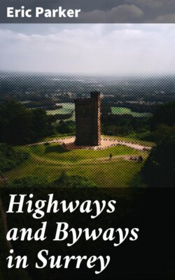
Along the Chalk Ridge.—Leith Hill in the Distance.
The Way became the Pilgrims' Way in 1174, four years after Thomas à Becket was murdered in Canterbury Cathedral. His tomb in the Cathedral became the second shrine in Christendom, and pilgrims came to it along the old trackway through Surrey, from Farnham east of the Hog's Back along the hills to Canterbury in Kent. Henry the Second, one of the earliest pilgrims of all, made his act of repentance a few days after landing at Southampton from France, on February 8, 1174. Or so legend relates, and adds that he swore to walk barefoot; history is less precise. After Henry the stream of devotees multiplied. Pilgrims landed, like Henry, at Southampton, or between Southampton and Chichester, and came through Winchester or Alton to Farnham; travellers from the West of England joined the foreigners at Winchester, or came to Farnham by the old Harrow Way, another ancient track from Salisbury Plain. Thousands made the journey; more and more followed year by year. At last it was determined to divide the stream. St. Thomas was murdered on December 29, and the great pilgrimage to Canterbury and the return centred round that date. In 1220 pilgrims were given a chance of paying their vows in summer as well as winter. St. Thomas's body, on July 7, was moved from the crypt under the nave to the grand altar in the nave, and from that day forward the Feast of the Translation took its share of the pilgrims' numbers. A constant stream journeyed east and west; travellers with vows unpaid met travellers returning from the shrine, and on and round the peopled highway sprang up booths and shelters to meet the pilgrim's needs. Pedlars and merchants hawked their wares and drove bargains by the road. Fairs were instituted in the villages along the route; strolling musicians earned idle wages; beggars sat by the roadside, at the churchyard corners, at the foot of the hills, and asked for alms.
The "Hog's Back."
And here, before we follow the pilgrims across the county from Farnham to the lane by which they leave it east of Titsey, I want to make a point clear. The pilgrims did not all travel to Canterbury by the same road, along the selfsame track so many feet wide, as the Ordnance map and some of those who have written on the Pilgrims' Way would argue. There is not one single, separate path along which every pilgrim who set out from Winchester to Canterbury travelled through Surrey. All that the pilgrims did was to journey forward either on, or near, the old Way from west to east and east to west, and it has happened that they used, more than any other track besides the Way itself, one particular road. This road can be followed parallel to the old Way for a long distance, running from church to church under the chalk ridge; and it is this road which is marked in the maps as the Pilgrims' Way. Perhaps that is convenient, but it should be understood that not all the pilgrims went by it. For pilgrims, after all, were as human then as walkers along country roads are to-day. They would not all want to do the same thing in the same way. Some of them would set out to do one thing and some another. Some would prefer to walk alone high up on the ridge; others would choose a bevy of companions and chatter along the road under the hill. Some would be thin, ascetic persons, who liked to stride along and see how far they could go without eating or drinking; some would be pleasant, good-tempered creatures, who would amble by dusty places and be thankful for cool beer; some would eat or drink mechanically, filled with a single thought of prayer and pilgrimage to a shrine. Some would be always perverse, and because most people travelled by one path, or halted at an easy spot, would choose deliberately another path, and halt where others passed on. Some would determine, come what might of wind or rain or sun, to sleep at a certain village at nightfall; others would let the weather decide for them. The weather would decide much, and it would choose differently for different travellers. One of the writers who has discussed the problems of the Pilgrims' Way suggests that the main route would vary with varying degrees of heat and cold. If the weather were cold and wet, the pilgrims would travel on the chalk ridge; and if it were hot, they would go by the leafy woodland path below. But if I Were a pilgrim and the weather were hot, I should go by the top of the ridge, so as to get the air and the view; probably I would go by the ridge in any case, whatever the weather was.
If written proof were needed that the journeying pilgrims Were not condemned to a sort of solemn observance of the rules of "Follow-my-leader," or bound by uncomfortable routine like so many Cook's tourists, it would not be difficult to find. From a paper on the Pilgrims' Way, written by Major-General E. Renouard James, you may learn that in 1463, nearly three hundred years after the first pilgrim followed Henry II to Canterbury, St. Martha's chapel by Guildford—St. Martha's being a corruption of "The Martyr's," that is, St. Thomas the Martyr's chapel—was in need of repair. And so, through the Prior of Newark, "forty days' indulgence was granted to such as should resort to this chapel on account of devotion, prayer, pilgrimage, or offering; and should there say Paternoster, the Angel's Salutation, and the Apostles' Creed; or should contribute, bequeath, or otherwise assign anything towards the maintenance, repair, or rebuilding of the same." But what does that mean? It must mean that not all the pilgrims went into St. Martha's to pray, or even went by St. Martha's on their way east. The Prior specially framed the terms of his indulgence to attract more pilgrims.
In Mr. Hilaire Belloc's admirably interesting book The Old Road, in which he describes the way in which he, sometimes with one companion and sometimes with two, sought out the exact track of a single Pilgrims' Way from Winchester to Canterbury, I find him writing of the compulsions of the pilgrimage—"The pilgrim set out from Winchester: 'You must pass by that well,' he heard, 'it is sacred.' … 'You must, of ritual, climb that isolated hill which you see against the sky. The spirits haunted it and were banished by the faith, and they say that martyrs died there.' … 'It is at the peril of the pilgrimage that you neglect this stone, whose virtue saved our fathers and the great battle.' … 'The church you will next see upon your way is entered from the southern porch sunward by all truly devout men; such has been the custom here since custom began.' From step to step the pilgrims were compelled to take the oldest of paths." Well, some of the pilgrims, perhaps most of them, since human nature imitates more often than it contradicts, may have been so compelled. But not all. I should like to set next to Mr. Belloc's passage a passage from the book of another pilgrim. Bunyan, when he wrote Pilgrim's Progress, may not have referred directly to the Way from Winchester to Canterbury, though his 'Vanity Fair' has been guessed to correspond with Shalford Fair, and other details of the progress have been fitted in with other happenings, as we shall see at Shalford. But unquestionably he reproduces the state of mind with which a pilgrim would undertake a journey, wherever his pilgrimage would take him. He was born only ninety years after the last pilgrim had paid his vows; he would have talked to men whose fathers had made the pilgrimage, and as he writes of it the keynote is voluntary choosing of the road. Here is the passage:—
"I beheld, then, that they all went on till they came to the foot of the hill Difficulty, at the bottom of which was a spring. There were also in the same place two other ways, besides that which came straight from the gate: one turned to the left hand, and the other to the right, at the bottom of the hill; but the narrow way lay right up the hill; and the name of that going up the side of the hill, is called Difficulty. Christian now went to the spring and drank thereof to refresh himself, and then began to go up the hill, saying—
'The hill, though high, I covet to ascend;
The difficulty will not me offend;
For I perceive the way to life lies here.
Come, pluck up heart, let's neither faint nor fear,
Better, though difficult, the right way to go,
Than wrong, though easy, where the end is woe.
The other two also came to the foot of the hill. But, when they saw that the hill was steep and high, and that there were two other ways to go; and supposing also that these two ways might meet again with that up which Christian went, on the other side of the hill; therefore, they were resolved to go in those ways. Now the name of one of those ways was Danger, and the name of the other Destruction. So the one took the way which is called Danger, which led him into a great wood; and the other, took directly up the way to Destruction, which led him into a wide field, full of dark mountains, where he stumbled and fell, and rose no more."
Now that is exactly the way in which the pilgrims might have separated and gone their own ways at a dozen places along the road to Canterbury. Take, to begin with, the joining and the parting of the ways at Farnham. Pilgrims would meet there, as we have seen, coming through Winchester, from Normandy, or by the Harrow Way from Salisbury Plain, from Wales, from Ireland, and all the West of England. But they would not all necessarily leave by the road that runs straight from Farnham to the foot of the Hog's Back. Some would have letters to the Abbot of Waverley, would spend a night at the Abbey two miles to the south-east, and join the others perhaps at Puttenham, six miles further along the Way. Then, among those who chose to travel straight to the western slope of the Hog's Back, there would be different minds at the foot of the hill. Some would climb the hill at Whitewaysend—the white way of the chalk would begin for them there—and would stride along in the sunlight the seven straight miles to Guildford. Others would prefer to keep to a path under the hill, stopping at the churches and gossiping at the inns. You can trace the old road clearly through Seale to Puttenham, where it must have travelled south of the church door, instead of taking the awkward and unnecessary turn to the north which is taken by the modern road. Then at Puttenham the pilgrims would divide again. Some would journey straight on across Puttenham Heath, heading towards St. Catherine's Hill—you can see the rough track; others would turn aside to the south-east, to visit Compton church; perhaps they would come down into Compton as you may come down into it from the east to-day, by what is evidently an old track cut deep in the woods. They would go up north again from Compton; perhaps they would be tired of the valley, and would climb the Hog's Back to walk the last mile or so into Guildford in the wind; perhaps they would join the other stream of pilgrims travelling by the sandy lane by which you may walk to-day as slowly as they did towards St. Catherine's Hill. Most of them, I think, would collect on St. Catherine's Hill; St. Catherine's was more popular than the Guildford churches. So General James has discovered, examining ancient records of litigation. The parson of St. Nicholas, Guildford, fearing to lose his profit from the pilgrims who visited the town, purchased from the lord of the manor the freehold of the site of the chapel, and rebuilt it in 1317. Perhaps the attraction of St. Catherine's was that it was on the way to Shalford Fair. Guildford had two special fairs, on May 4 and November 22, to catch the summer and the winter pilgrims. But Shalford Fair was the great fair, and actually covered 140 acres of ground.
Coming in to Puttenham.
The pilgrims would cross the Wey under St. Catherine's Hill by a ferry or a rough plank bridge. The merchants travelling with their horses, and the ponies driven from Weyhill Fair out towards Salisbury Plain, would come through the water by a ford. But the ferry and the bridge were both of almost immemorial antiquity. In 1736 there was a dispute about the bridge. The lord of the manor of Brabœuf had built a bridge over the Wey for a fair on St. Matthew's Day. The owner of the church lands at Shalford ordered it to be destroyed; he claimed the right of conveying passengers over the river. They went to law, and it was alleged that there had been a bridge there time out of record. Judgment, however, decided "that there had been no bridge except per unum battellum (one plank) at the mill belonging to the heirs of Henry de la Poyle (a mile lower), laid for convenience of the pilgrims going to the chapel of St. Katherine at the time of the fair." General James has unearthed the decision of the Court, and incidentally added another bypath to the Pilgrims' Way.
Opposite the ferry under St. Catherine's the line of the Way to St. Martha's is clear enough, a green track in a green field; and once I saw it as the pilgrims may have seen it on a spring morning. It was in May, and there was a haze over the meadowland by the river which blurred shapes and colours. St. Catherine's was no longer a ruin; the buildings on the hill faded into the trees; the clothes of wanderers by the riverside took on mediæval brightnesses, lost modern forms; and into the foreground ran three bare-headed, yellow-haired children, and in their brown arms great bunches of cuckoo-flowers. So might one returning from the Martyr's chapel have seen the path to the ferry in the days when the Clerk told the tale of Griselda.
The track crosses the road near the ferry, and by a wood named the Chantries comes up to St. Martha's, at the foot of the hill a close-cropped aisle of down grass, and nearer the top a loose, sandy path among pines. At the base of the hill the pilgrims who had come by the ferry would be joined by those who had left Guildford by Pewley Hill, to come out through the valley past Tytings, now a private residence, but once the dwelling of St. Martha's priest. And on the other side of the hill a difficulty waits. Mr. Belloc traces the road from the foot across a ploughed field, to connect with a narrow lane on the other side of the road dropping from Newlands Corner to Albury. Well, it is possible that some of the pilgrims strayed out in that direction, though it means that they would have to descend a bank like the wall of a house by the Newlands Corner road, which is a sunken track; also, Mr. Belloc owns that a little further on this road he chooses has a doubtful section of a mile and a half. May he not be on the wrong road? Why should not the pilgrims drop down the road which leads from the foot of St. Martha's Hill into Albury? The inns would have tempted them; they would be heading straight for the church; and the road leading to inns and church is clearly a road that led from St. Martha's Hill into the valley of the Tillingbourne long before the hill bore a Christian chapel. It is evidently an old British trackway. It runs along a ridge, and yet it is sunk deep between two very high banks. If it was there when the pilgrims came down from the Martyr's chapel, why should they make a fresh track for themselves, especially one which, as Mr. Belloc admits, "raises a difficulty unique in the whole course of the way"? The track he follows goes by the wet, northward side of a hill—"an exception to an otherwise universal rule."
I have no space to follow the way in detail through the country, but this particular section seemed to me to illustrate clearly the need for imagining what the pilgrims would be likely to do, rather than to try to fit in their doings with a particular path or lane through Albury. I do not see why the pilgrims should not have followed the same route as we travel by to-day. Doubtless by what is now Albury Park the road has become confused. May it not have led through Albury Park past the south porch of the ruined church, and so come in a natural way to Shere church by the old inn? All five would then lie in a line—the old track from the Martyr's chapel, Albury Church, the White Horse Inn, the short road to Shere Church, and the track that leads up from Gomshall to the flank of the downs again. But that is only guessing; the line on the maps tempts it.
East of Gomshall to Oxted almost on the county border the track of the old Way and of the Pilgrims' Ways, sometimes coinciding, sometimes running parallel to each other, runs along the crest and the southern slopes of the chalk ridge. Yews and wind-bent thorn mark the ways, sometimes, as east of Gomshall, by a clear cut ridge in the hill, lined with ancient trees; sometimes, as under Denbies by Dorking, you can only pick out the path by solitary yews studding grass fields and corn-land. At the gap of the Mole by Dorking the old Way, perhaps, forded the Mole; the pilgrims would cross by Burford Bridge, which joins the Roman Ermyn Street to Stane Street beyond Dorking. Both the Way and the pilgrims' track would join on the line of yews on Box Hill, and from Box Hill to Reigate there is a succession of yew road-marks and hedges, with here and there the whole face of the downs bitten out by a chalk pit; gradually the road climbs, until the track above Reigate lies almost on the highest point of the ridge. At Reigate the old Way carries on, crossing the hill-road which was from the town north to London. The slope of the modern road has been eased by cutting into the hill, and the ancient Way now is joined, on Reigate Hill, by a suspension bridge.
But the pilgrims would drop down into the town to sleep and to eat and drink. You may see their tracks on the chalk, streaming down from the ridge like a bunch of white ribands in the wind. They came into Reigate by Slipshoe Lane, and there, where the cross roads meet, they stood to pray at St. Thomas's shrine, now no more.
By Slipshoe Lane to the Red Cross Inn, Reigate.
They would please themselves where they climbed the ridge again. Or they joined the old Way, perhaps, in what is now Gatton Park, where the yews point to Merstham church. After Merstham the tracks divide again. East of an interrupting chalk pit, a thick yew hedge lines the side of the hill, under which I once ate fine blackberries in December, as perhaps the Wife of Bath ate them. But half way along the ridge of yews another path climbs up a plough, and on the crest it joins a narrow lane which is as much the Pilgrims' Way as any road on the downs; it runs by Tollsworth Farm over the summit of White Hill, and is actually marked "The Pilgrims' Way" twice on the sign posts, so sure are the local painters of what they have to point out. East from White Hill you may follow a single track, sometimes grass, sometimes modern road. There is a puzzle at Godstone Quarry, where the chalk pits have cut the hill to pieces, and the tiny path which perhaps still keeps the line across the pits is a perilous slippery place in the rain. On the far side of to-day's road by the chalk pit you may pick up the green track again, though you will lose it rounding the spur of the hill that lies half way between Godstone and the railway. The old Way probably still kept to the ridge, and Sir Gilbert Scott thought he had traced the Pilgrims' Way through the Hanging Wood north of Tandridge Hill Lane. But I think I found it in a green track which runs westward from a gap in that same lane. It looked like a rough cart-track through a field, and would join the road already traced beyond. In its centre, a foot from the ground, was placed, and doubtless remains, a blue enamelled notice board, with the brief but usual caution to trespassers.
East of Tandridge Hill Lane, on the far side of a grass field, a curious path, half ditch, half avenue of yews and thorns, leads down through woodland to green trackway again. The green track crosses the railway cutting, and so journeys on into Titsey Park on the level lowland. Under the new Titsey church it runs, as it once ran past the old church in the Park, and from Titsey church eastward, by a country lane through broad and glorious cornfields, it passes out of Surrey into Kent.
By those ways they went, fur-clad Briton, ravaging Dane, Roman eagle, traders of tin and drivers of ponies, along the ridge in the sun and the wind and the rain; by their side and after them, along the ridge and under it, travelled the knight and the clerk and the friar and the summoner, as they travelled from the Tabard Inn to St. Thomas's shrine with Chaucer; and we may follow them, beginning with Surrey's western town, and journeying at the end from the Tabard again, with the pilgrims passing to the east.