Читать книгу A Canyon Voyage - Frederick Samuel Dellenbaugh - Страница 3
На сайте Литреса книга снята с продажи.
ОглавлениеILLUSTRATIONS
Table of Contents
Facing Page
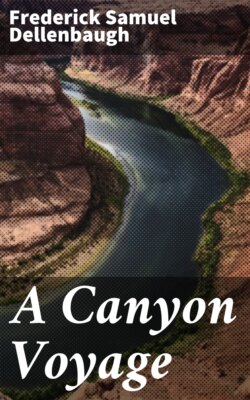
The Grand Canyon FrontispieceLooking south from the Kaibab Plateau, North Rim, near the head of Bright Angel Creek, the canyon of which is seen in the foreground. The San Francisco Mountains are in the distance. On the South Rim to the right, out of the picture, is the location of the Hotel Tovar. The width of the canyon at top in this region is about twelve miles, with a depth of near 6000 feet on the north side, and over 5000 on the south. Total length, including Marble Canyon division, 283 miles.Sketch made in colour on the spot by F. S. Dellenbaugh, June 4, 1903.
The Toll 1Unidentified skeleton found April, 1906, by C. C. Spaulding in the Grand Canyon 300 feet above the river, some miles below Bright Angel trail. There were daily papers in the pocket of the clothes of the early spring of 1900.Photograph by Kolb Bros. 1906, Grand Canyon, Arizona.
Red Canyon 6Photograph by E. O. Beaman, 1871.
Before the Start at Green River City, Wyoming 9The dark box open. Andy, Clem, Beaman, Prof. Steward, Cap., Frank, Jones, Jack, the Major, Fred, Cañonita, Emma Dean, Nellie Powell.Photograph by E. O. Beaman, 1871.
Flaming Gorge 17The beginning of the Colorado River Canyons, N. E. Utah.Photograph by E. O. Beaman, 1871.
Horseshoe Canyon 21Photograph by E. O. Beaman, 1871.
Red Canyon 25Photograph by E. O. Beaman, 1871.
Red Canyon 28Ashley Falls from below.Photograph by E. O. Beaman, 1871.
In Red Canyon Park 29Photograph by E. O. Beaman, 1871.
The Head of the Canyon of Lodore 34Just inside the gate.Photograph by E. O. Beaman, 1871.
Canyon of Lodore 37Low water.Photograph by J. K. Hillers, 1874.
The Heart of Lodore 40F. S. Dellenbaugh.Photograph by E. O. Beaman, 1871.
Canyon of Lodore—Dunn's Cliff 432800 feet above river.Photograph by E. O. Beaman, 1871.
Canyon of Lodore 44Jones, Hillers, Dellenbaugh.Photograph by E. O. Beaman, 1871.
Echo Park 49Mouth of Yampa River in foreground, Green River on right.Photograph by E. O. Beaman, 1871.
Whirlpool Canyon 54Mouth of Bishop Creek—Fourth of July camp.Photograph by E. O. Beaman, 1871.
Split Mountain Canyon 59Photograph by E. O. Beaman, 1871.
Canyon of Desolation 81Steward.Photograph by E. O. Beaman, 1871.
Colorado River White Salmon 98Photograph by the Denver, Colorado Canyon and Pacific Railway Survey under Robert Brewster Stanton, 1889.
Dellenbaugh Butte 102Near mouth of San Rafael.Photograph by E. O. Beaman, 1871.
Labyrinth Canyon—Bowknot Bend 108The great loop is behind the spectator.Photograph by E. O. Beaman, 1871.
Stillwater Canyon 110Photograph by E. O. Beaman, 1871.
Cataract Canyon 119Clement Powell.Photograph by E. O. Beaman, 1871.
Cataract Canyon 128Photograph by E. O. Beaman, 1871.
Narrow Canyon 133Photograph by Best Expedition, 1891.
Mouth of the Fremont River (Dirty Devil) 135Photograph by the Brown Expedition, 1889.
Glen Canyon 140Photograph by E. O. Beaman, 1871.
Looking Down Upon Glen Canyon 142Cut through homogeneous sandstone.Photograph by J. K. Hillers, U. S. Colo. Riv. Exp.
Tom 147A typical Navajo. Tom became educated and no longer looked like an Indian.Photograph by Wittick.
Glen Canyon 149Sentinel Rock—about 300 feet high.Photograph by E. O. Beaman, 1871.
The Grand Canyon 162From Havasupai Point, South Rim, showing Inner Gorge.From a sketch in colour by F. S. Dellenbaugh, 1907.
The Grand Canyon 168From South Rim near Bright Angel Creek.
The Grand Canyon 174From part way down south side above Bright Angel Creek.
Winsor Castle, the Defensive House at Pipe Springs 186Photograph by H. Arthur Pomroy, 1903.
Little Zion Valley, or the Mookoontoweap, Upper Virgin River 186Photograph by H. Arthur Pomroy, 1903.
In the Unknown Country 195Photograph by J. K. Hillers, 1872.
Navajo Mountain From Near Kaiparowits Peak 201Photograph by J. K. Hillers, 1872.
Tantalus Creek 206Tributary of Fremont River.Photograph by J. K. Hillers.
Example of Lakes on the Aquarius Plateau 211Photograph by J. K. Hillers.
The Grand Canyon 215Near mouth of Shinumo Creek. The river is in flood and the water is "colorado."Sketch made in colour on the spot by F. S. Dellenbaugh, July 26, 1907.
Marble Canyon 219Thompson.Photograph by J. K. Hillers, 1872.
Canyon of the Little Colorado 222Photograph by C. Barthelmess.
The Grand Canyon 224From just below the Little Colorado.Photograph by J. K. Hillers, 1872.
The Grand Canyon 227Running the Sockdologer.From a sketch afterwards by F. S. Dellenbaugh.
The Grand Canyon 232From top of Granite, south side near Bright Angel Creek.
The Grand Canyon 238Character of river in rapids.Photograph by F. S. Dellenbaugh, 1907.