Читать книгу Native Americans: 22 Books on History, Mythology, Culture & Linguistic Studies - Льюис Спенс, James Mooney - Страница 49
На сайте Литреса книга снята с продажи.
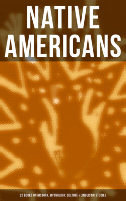
Territory of Cherokees at Period of English Settlement
ОглавлениеTable of Contents
At the time of the English settlement of the Carolinas the Cherokees occupied a diversified and well-watered region of country of large extent upon the waters of the Catawba, Broad, Saluda, Keowee, Tugaloo, Savannah, and Coosa Rivers on the east and south, and several of the tributaries of the Tennessee on the north and west. It is impossible at this late day to define with absolute accuracy the original limits of the Cherokee claim. In fact, like all other tribes, they had no definite and concurrent understanding with their surrounding savage neighbors where the possessions of the one left off and those of the other began. The strength of their title to any particular tract of country usually decreased in proportion to the increase of the distance from their villages; and it commonly followed as a result, that a considerable strip of territory between the settlements of two powerful tribes, though claimed by both, was practically considered as neutral ground and the common hunting ground of both.
As has already been stated, the extreme eastern settlements of the Cherokees in South Carolina in 1693 were in the district of country lying between the Catawba and Broad Rivers, and no claim has been found showing the existence at any time of any assertion of territorial right in their behalf to the east of the former stream. But nevertheless, on Bowen's map of 1752 (obviously copied from earlier maps), there is laid down the name of "Keowee Old Town." The location of this town was on Deep River in the vicinity of the present town of Ashborough, N. C. It was a favorite name of the Cherokees among their towns, and affords a strong evidence of at least a temporary residence of a portion of the tribe in that vicinity. A map executed by John Senex in 1721 defines the Indian boundary in this region as following the Catawba, Wateree, and Santee Rivers as far down as the most westerly bend of the latter stream, in the vicinity of the boundary line between Orangeburg and Charleston districts, whence it pursued a southwesterly course to the Edisto River, which it followed to the sea-coast. The southern portion of this boundary was of course a definition of limits between Carolina and the Creeks, or rather of certain tribes that formed component parts of the Creek confederacy. No evidence has been discovered tending to show an extension of Cherokee limits in a southerly direction beyond the point mentioned above on the Edisto River, which, as near as can be ascertained, was at the junction of the North and South Edisto. Following from thence up the South Edisto to its source the boundary pursued a southwesterly course, striking the Savannah River in the vicinity of the mouth of Stevens Creek, and proceeding thence northwardly along the Savannah.
On the borders of Virginia and North Carolina the ancient limits of the Cherokees seem to be also shrouded in more or less doubt and confusion. In general terms, however, it may be said that after following the Catawba River to its source in the Blue Ridge the course of those mountains was pursued until their intersection with the continuation of the Great Iron Mountain range, near Floyd Court-House, Va., and thence to the waters of the Kanawha or New River, whence their claim continued down that stream to the Ohio. At a later date they also set up a claim to the country extending from the mouth of the Kanawha down the Ohio to the ridge dividing the waters of the Cumberland from those of the Tennessee at the mouths of those streams, and thence following that ridge to a point northeast of the mouth of Duck River; thence to the mouth of Duck River on the Tennessee, and continuing up with the course of the latter river to Bear Creek; up the latter to a point called Flat Rock, and thence to the Ten Islands in Coosa River, &c.
That portion of the country thus covered, comprising a large part of the present States of West Virginia and Kentucky, was also claimed by the Six Nations by right of former conquest, as well as by the Shawnees and Delawares.
Adair, a trader for forty years among the Cherokees, who traveled extensively through their country about the middle of the eighteenth century, thus specifically outlines the boundaries of their country at that period: "The country lies in about 34 degrees north latitude at the distance of 340 computed miles to the northwest of Charlestown,—140 miles west-southwest from the Katahba Nation,—and almost 200 miles to the north of the Muskohge or Creek country. They are settled nearly in an east and west course about 140 miles in length from the lower towns, where Fort-Prince-George stands, to the late unfortunate Fort Loudon. The natives make two divisions of their country, which they term 'Ayrate' and 'Otarre,' the one signifying 'low' and the other 'mountainous.'"