Читать книгу Cartography and the Political Imagination - Julie MacArthur - Страница 6
На сайте Литреса книга снята с продажи.
ОглавлениеOhio University Press, Athens, Ohio 45701
ohioswallow.com
© 2016 by Ohio University Press
All rights reserved
To obtain permission to quote, reprint, or otherwise reproduce or distribute material from Ohio University Press publications, please contact our rights and permissions department at (740) 593-1154 or (740) 593-4536 (fax).
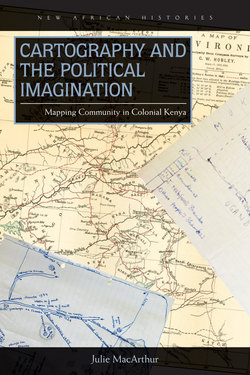
Cover art: (background) C. W. Hobley, map of Kavirondo, 1898. Hobley, “Kavirondo”; (upper right corner) sketch map of Jeremiah Nabifwo’s property. 19 January 1959, KPA, WD/4/5; (lower left corner) sketch map of M. Mbango s/o Linyonyi’s property. 16 June 1956, KNA, PC/NZA/3/15/68.
Printed in the United States of America
Ohio University Press books are printed on acid-free paper ™
26 25 24 23 22 21 20 19 18 17 16 5 4 3 2 1
Library of Congress Cataloging-in-Publication Data
Names: MacArthur, Julie, 1982– author.
Title: Cartography and the political imagination : mapping community in colonial Kenya / Julie MacArthur.
Other titles: New African histories series.
Description: Athens, Ohio : Ohio University Press, 2016. | Series: New African histories | Includes bibliographical references and index.
Identifiers: LCCN 2016005708| ISBN 9780821422090 (hc : alk. paper) | ISBN 9780821422106 (pb : alk. paper) | ISBN 9780821445563 (pdf)
Subjects: LCSH: Luyia (African people)—Kenya—History. | Ethnicity—Political aspects—Kenya. | Cartography—Political aspects—Kenya. | Cartography—Social aspects—Kenya. | Kenya—Ethnic relations—History.
Classification: LCC DT433.545.L88 M33 2016 | DDC 305.896395—dc23
LC record available at http://lccn.loc.gov/2016005708