Читать книгу 50 Things to See and Do in Northern New Mexico's Enchanted Circle - Mark D. Williams - Страница 6
На сайте Литреса книга снята с продажи.
ОглавлениеINTRODUCTION
Both of our families have been coming to the Enchanted Circle since we were kids. As a couple, we’ve been coming here for the last twenty-five years and have a second home in Taos; we love this part of the world that much. We have traveled together all over the world but keep coming back to the Southwest, keep coming back to the Enchanted Circle.
We are both teachers (Mark for high school, and Amy for elementary) and we will each be retiring soon. We chose Taos as our retirement home. The climate is great, the food sublime, the fishing and outdoor recreation top notch, the skiing world class, and the people friendly and interesting. The Enchanted Circle has great craft brews and award-winning wineries, unique shopping, an interesting mixture of so many cultures that produced this weird, cool, awesome culture of clothing, cuisine, rugs, sculpture, paintings, literature, and so much more. From Taos, we are close to the Colorado border; close to Santa Fe and Las Vegas, New Mexico; close to Texas. We are also close to several ski resorts, dozens of trout streams, hundreds of miles of hiking trails, and, of course, we are close to some of the finest restaurants in the Southwest.
The Enchanted Circle is a unique result of history and geography. The region enjoys a rich tapestry of peoples and culture. Tourism is the driving economic force for the Enchanted Circle’s communities today and they see up to a million visitors annually. We enjoy and love the region so much, have explored so many of its secrets and joys, that we felt obliged and honored to share it with you.
GETTING TO TAOS & THE ENCHANTED CIRCLE
Generally there are two primary routes to get to the Enchanted Circle: 1) from the southwest (Albuquerque or Santa Fe) or 2) from the east, hitting Cimarron into Eagle Nest. If you are coming from Santa Fe for a day trip or longer, you can take the High Road or the Low Road to reach the Enchanted Circle. Which is better? We like going up the High, coming back the Low. The other main entry into the Enchanted Circle is through Cimarron and Eagle Nest on the eastern side of the byway. You cut off on NM 58 west to US 64 west at Cimarron then on to Eagle Nest.
Cities near Taos and the Mileage to the Enchanted Circle Starting at Taos Plaza
From Albuquerque: 135 miles, 2.5 hours. I-25 north to Santa Fe; exit on NM 599 north to bypass Santa Fe; US 285 north to NM 68 north to Taos.
From Breckenridge: 263 miles, 4 hours. CO 9 south to Fairplay; US 285 south and CO 17 south to Alamosa; US 285 south to Tres Piedras; US 64 east to Taos.
From Crested Butte: 271 miles, 4.5 hours. CO 135 south to Gunnison; US 50 east to US 285 south to CO 17 south to Alamosa; US 285 south to Tres Piedras; US 64 east to Taos.
From Denver: 300 miles, 4.5 hours. I-25 south to Colorado Springs to Walsenburg; US 160 west to Fort Garland; CO 159 south and NM 522 south to Taos.
From Durango: 208 miles, 3.25 hours. US 160 east to Pagosa Springs; US 84 east to Chama; CO 17 south to Antonito; US 285 south to Tres Piedras; US 64 east to Taos.
From Vail: 276 miles, 4.5 hours. I-70 east to Copper Mountain; CO 91 south to Leadville; US 24 east and CO 17 south to Alamosa; US 285 south to Tres Piedras; US 64 east to Taos.
From Amarillo: 302 miles, 4.5 hours. I-40 west to Clines Corners; US 285 north to I-25 south to Santa Fe; US 84/285 to NM 68 north to Taos.
—from taos.org/plan-your-trip/getting-around/
THE ENCHANTED CIRCLE MILE BY MILE
This mile-by-mile chart is to be used as you plan your driving trip around the Enchanted Circle starting with Taos Plaza intersection as your genesis. Set your mileage counter at zero and you’ll be able follow the chart along your route.
| Ground Zero TAOS PLAZA intersection | |
| 0.1 | Kit Carson Park |
| 0.5 | Split to Taos Pueblo on the right, but stay left (north) on NM 522 |
| 1.2 | Taos Pueblo entrance right (east) on Hail Creek Road. This is a second entrance to the Taos Pueblo. You’ll see the smoke shop just off the road to your left when you turn. |
| 2.1 | Historical marker (Taos history) on right with pullout |
| 2.4 | Overland Ranch complex |
| 3.9 | Cutoff to Arroyo Seco and Taos Ski Valley right (east) on NM 150 |
| 4.0 | Four-way light (the Old Blinking Light). Turn left (west) on US 64 to Rio Grande Gorge and Earthships, north on NM 522 to Questa. |
| 5.3 | Historical marker (Taos/Gorge) on left |
| 10.5 | Cross the bridge over Rio Hondo and turn left (west) on B006 and, after a bit, B007 to go to John Dunn Bridge over Rio Grande; here you start your climb to Questa (the road keeps climbing for a good ways). |
| Scrub oak, juniper, sage, mountains to your right. | |
| 13.8 | Historical marker (D.H. Lawrence Ranch) and entrance on the right to D.H. Lawrence Ranch |
| 14.5 | San Cristobal |
| Still climbing (piñon and juniper). | |
| 17.3 | Garrapata Canyon |
| 17.9 | Cebolla Mesa (left) includes parking area |
| 20.0 | Red River Hatchery turnoff (turn left or west on NM 515 for 2 miles) |
| 21.3 | The valley opens up in front of you and you can see the edge of Questa. |
| 21.9 | “Questa Welcomes You” sign |
| 22.5 | Crossing bridge over Red River |
| 23.7 | Traffic light. To get to Red River, turn right (east) on NM 38 and follow for winding 12 miles ahead. |
| 24.0 | Historical marker (Cienega) on the right |
| Note you are leaving scrub oak and seeing more pine trees. | |
| 25.2 | Eagle Rock Lake Day Use Area (right) |
| 25.5 | Red River to the right |
| 27.1 | Goat Hill Campground (Molycorp Mine begins to your left) |
| Watch for bighorn sheep and retaining walls and slides here and there. | |
| 28.7 | Columbine Creek Canyon Hike (right) |
| Curvy road past aspens and pines. | |
| 30.3 | Molycorp Mine in full view to your left |
| 31.8 | Ascent and curves; La Bobita Campground (left) |
| 32.8 | Elephant Rock Campground (left); recent slide near |
| 33.2 | Fawn Lakes Campground |
| 33.9 | June Bug Campground |
| 34.2 | Historical marker (Red River Valley) on right |
| You are on edge of the town of Red River. | |
| 35.0 | Welcome to Red River. Slow down. |
| 35.8 | Red River Community House |
| 37.0 | Road splits. Go left (east) on NM 38 to Bobcat Pass and Eagle Nest (to continue on Enchanted Circle); curvy high mountain road; right (southeast) on NM 578 goes to upper Red River for alpine sightseeing, headwaters fishing. |
| 38.7 | Enchanted Forest Cross Country Ski Area (MM16) |
| 39.2 | Bobcat Pass (9,820 feet) |
| You are going downhill now. Don’t ride your brakes. Shift to lower gears. | |
| 47.1 | Elizabethtown on the right. You will see a weathered “Gold Rush Days” sign to your left. The ghost town is across the road to your right. |
| Now you’ll drop down even more and pass fewer aspens. | |
| You’ll start to see the edge of the Eagle Nest community. | |
| 50.9 | Welcome to Eagle Nest. Stop and enjoy here; perhaps visit Cimarron (US 64 E) as a nice side trip. You reach the Cimarron River in about a mile and will drive 24 miles east along the river to get to the village of Cimarron. Those 24 miles are winding and the speed limit low so it takes at least 35 to 40 minutes. |
| 51.9 | Passing NM 38/US 64 intersection |
| 53.2 | Eagle Nest Lake State Park entrance |
| 55.4 | Pullout for Wheeler Peak in the distance |
| 56.9 | Day use area |
| 60.4 | Vietnam Veterans Memorial State Park |
| 61.2 | NM 434. Angel Fire (8,420 feet) to your left (east) |
| 0.0 | Turn left on NM 434 |
| 0.7 | Angel Fire Airport |
| 2.6 | Entrance to resort (left) and visitors center (right) |
| 62.6 | Elliot Barker Trail 1 |
| 64.4 | Palo Flechado Pass |
| Coming down, you’ll enter Taos Canyon. | |
| 69.5 | Valle Escondido |
| 74.6 | Shady Brook |
| 75.0 | La Sombra Day Use Area |
| 78.2 | Historical Marker (Taos Canyon) on the right |
| 79.6 | Devisadero Trail and South Boundary Trails off to the left and “Welcome to Taos” sign to the right |
| 80.0 | Split intersection. Take a right (north) on NM 68, 3 miles to Taos Plaza |
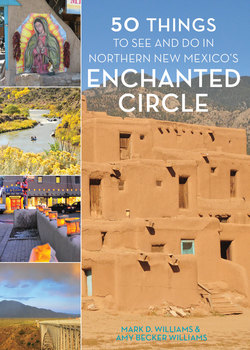
From left to right, top: San Francisco de Asís Church; a sign of the Enchanted Circle; San José de Gracia Church. Middle: Rio Grande Gorge Bridge. Bottom: the state flag flying outside shops in Taos; religious mural in Chimayó.
THE ENCHANTED CIRCLE
| Distance: | 84 miles, 2.5 to 3 hours if you drive with minimal stops. Plan on a full day if you stop in each town and to take pictures. |
| Route: | From Taos Plaza, US 64 north to NM 522 north to Questa; NM 38 east to Red River, then continue on US 64 south to Eagle Nest and Angel Fire; US 64 west back to Taos. |
Most visitors to the Enchanted Circle will come from Albuquerque and Santa Fe, and then go along the High Road or the Low Road. Here’s the route of the Enchanted Circle: From Taos, take NM 522 North to Questa. At Questa, catch NM 38 east to Red River. Then go from Red River east to Elizabethtown continuing on NM 38, south to Eagle Nest. From Eagle Nest, head south on US 64 to Angel Fire. From Angel Fire, stay on US 64, back to Taos. The other main entry into the Enchanted Circle takes place through Cimarron and Eagle Nest on the eastern end of the byway. If you enter the Enchanted Circle from the east, you will cut off on NM 58 west to US 64 west at Cimarron then on to Eagle Nest. The trick is to choose your route and time wisely. Remember to be prepared for changing weather, especially during monsoon season from mid-July through September.
The Enchanted Circle is a spectacular 84-mile loop drive through mountains, mesa, great rifts, valleys and national forest, sprawling ranches, a gold-mining ghost town, cold clear streams, and a large unusual national monument. This US Scenic Byway hosts hundreds of thousands of visitors annually. The landscapes are varied and dramatic, unique to New Mexico. The diversity and beauty, grandeur and simplicity, sweeping vistas of mountains and of valleys—all in a circle—are breathtaking. Rarely will you find such differing landscapes, cultures, towns and villages, and lay of the land in such a small area.
The Rio Grande Gorge charms and awes its seekers.
The genesis of your drive around the Enchanted Circle will be dominated by a rift, a river, a range; to the west lies a ragged gash of earth, the Rio Grande Gorge, which divides the ancient volcanic cones from the snow-capped Sangre de Cristo Range to the east. The Enchanted Circle travels around New Mexico’s largest mountain, Wheeler Peak, part of the Sangre de Cristo Mountain Range that spans from Southern Colorado to the southern parts of New Mexico. Steeped in history and raw beauty, this drive features expansive views, diverse landscapes, and frequent remnants of the Wild West.
This is a loop trip. You are driving in a circle. Easy as pie. Drive it, and you get a threefold reward: amazing scenery, a million things to do, and cool mountain villages. By cool, we mean the kind of cool a Popsicle provides in summer, and the type of cool that you wished you had when you watched Dean Martin and The Golddiggers on television. Each town has its own vibe, its own identity, its own charm.
This National Forest Scenic Byway circles Wheeler Peak, the highest point in New Mexico at 13,161 feet. Throughout the drive, you’ll see some of the oldest rocks in the Southwest—quartz and feldspar that date back two billion years. You can view ancient petroglyphs, golden eagles, snow-capped peaks, historic sites, and Indian pueblos. Watch for special Enchanted Circle markers to help guide your way.
Exploring the Enchanted Circle Scenic Byway is a perfect way to spend an adventurous weekend or a week or two. The byway is only about 84 miles, but there is so much to see that you will want to take your time to see it all. As you drive out of Taos on NM 522, take a detour to see the Rio Grande Gorge Bridge, one of the highest bridges in America. Take a detour to the east so you can visit Arroyo Seco, a quaint artistic village on the road to the internationally flavored Taos Ski Valley.
As you continue north, you’ll pass scenic Arroyo Hondo. After San Cristobal, visit the ranch where famous writer D.H. Lawrence lived. To the east, you will see the towering Sangre de Cristo Range. Passing Questa, you will encounter truly dramatic landscapes with access to the Rio Grande. A steep road to the east takes you to the mountain hamlet of Red River, which offers a spectacular vista of aspen and spruce groves.
Continue along the Enchanted Circle from NM 38 to US 64 through Eagle Nest Lake State Park with a spectacular 2,400-acre lake that’s excellent for hiking, fishing, boating, and cross-country skiing. Watch for deer, elk, bear, and eagles. As you continue west, you will pass Angel Fire, another great family resort on the way back to Taos.
You can visit eight historical pueblos (Native American settlements) during your stay in northern New Mexico, the most famous of which is the Taos Pueblo. The nearby forested mountains abound in game: deer, elk, bear, and wild turkey. Seasonal trout fishing is outstanding in mountain lakes and streams and year-round in the Rio Grande. Try horseback riding through valleys surrounded by snow-capped peaks. Consider a raft trip down the Rio Grande River. Skiing and snowboarding may be enjoyed at several nearby resorts from Thanksgiving to Easter—Taos Ski Valley, Red River, Angel Fire, and Sipapu.
Opportunities for hiking and biking are plentiful on miles of developed trails in these areas offering dramatic vistas, wildlife viewing, solitude, and visits to prehistoric and historic cultural sites. There are hundreds of miles of trails, some maintained by volunteer groups. Opportunities also abound for hiking, horseback riding, mountain biking, and four-wheel-drive (4WD) exploring. Many summer hiking trails and forest roads become cross-country ski and snowmobile trails in winter.
HISTORY
This was wild country fully tamed only 120 years ago. Let that sink in. New Mexico only became a state in 1912. This region is still one of the wildest and most remote in the Southwest.
The history of northern New Mexico can be explained in waves. One wave of people came after another: the Pueblo Indians followed by Spanish, Anglo, Mexican, traders, Eastern Americans, artists and painters and writers, hippies and counter-culturalists. And the latest wave? Tourists from around the world. The nineteenth-century commercial highway Santa Fe Trail ran through this area, connecting the civilized world with the Wild West. Kit Carson, Bishop Jean-Baptiste Lamy, Father Jose Martinez, and other frontier heroes lived here, fought here, for varying reasons. Outlaws and famous Western personalities were a part of the historic fabric too, including Wyatt Earp, Jesse James, Buffalo Bill Cody, Annie Oakley, Billy the Kid. When horses and wagons were replaced by trains, the region continued to be a crossroads for trade and travelers.
The sign marking the historic San José de Gracia Church.
The history includes the Pueblo Indians, who lived under various rulers while trying to keep as much of their culture as they could. Once you visit the pueblos, you’ll see that they were extraordinarily successful even through cultural intrusion and forcible control. First came the Spanish, then Mexican, and finally Americans. The Pueblo Indians eventually lived next to and with Anglos (sometimes) and Mexicans. We used to hear about how these three groups formed a tricultural community, but the area’s population is more complex and varied than that simplified view would have you believe. The region’s history saw revolts and reservations, barbed wire and cattle, six-shooters and bows and arrows, priests and outlaws, land grants and mining, bears and llamas, miners and hippies. Northern New Mexico is a melting pot of different cultures. Now, the region bends to tourism, with hundreds of thousands from around the world visiting each and every year, and it’s only growing in numbers.
WEATHER
The region enjoys over three hundred days of sunshine a year and generally has a moderate climate, although it ranges from the dryness and heat of the high desert to the cool summers and bitter cold of the alpine mountains. The weather changes quickly here, so be prepared. In summer, it can be pleasantly cool in the morning, hot during lunch, rain and cooling in the afternoon, hot again before dinner, perfect temperature for outdoors eating by supper. In winter, you may see many bluebird days that reach into the fifties (degrees Fahrenheit), even sixties, but before you can blink, a snowstorm will have moved in and dumped a foot of snow. Again, be prepared.
July and August, the so-called monsoon season, are rainy months with almost daily afternoon showers. Make your plans accordingly. Mornings don’t usually have as much rain as the afternoons. Visitors should carry rain gear. Daytime temperatures in the summer range from highs in the fifties to seventies in the higher elevations, and seventies to high eighties in the lower. Breaking ninety is not common, but it can happen. Many places have air conditioning, though you’ll be surprised by how many do not. Adobe walls tend to keep temperatures inside cool and constant after all.
Magical winter snowfall in Taos.
Temperatures can drop dramatically when a storm moves in. Nights are cool, worthy of a jacket, and by fall they’re occasionally below freezing. Snowfall usually begins in early October. If you are hiking, beware of lightning on the ridges. Since you will probably be the highest point around, get off the ridge if thunderclouds are overhead.
Be sure to take proper clothing. Temperatures can drop suddenly in all seasons. Wet clothing can chill the body quickly. You can wear the space-age wicking materials, shells, or old-fashioned wool. But cotton next to the skin will keep the body damp and will actually wick heat away. That means jeans. Dress in layers that can be added or removed as the temperature changes.
Remember, the weather is sort of like the Enchanted Circle laid-back vibe. No hurry. You’re on New Mexico time. Climate is perfect, and if it’s not sunny at that moment, wait a few minutes; it will be soon.
DANGERS
ALTITUDE SICKNESS
Your body is not used to higher elevations, and if you try to do too much too soon, you’ll likely suffer the effects of altitude sickness. Altitude sickness is a group of symptoms that range from headaches to vomiting.
The pressure of the air that surrounds you is called barometric pressure. When you venture into higher altitudes, this pressure drops and there is less oxygen available. Your body needs time to adjust to the change in pressure. There are three kinds of altitude sickness: acute mountain sickness (the mildest form), high-altitude pulmonary edema (a buildup of fluid in the lungs), and high-altitude cerebral edema (fluid in the brain).
Signs of altitude sickness:
• Headache
• Dizziness
• Nausea
• Vomiting
• Fatigue and loss of energy
• Shortness of breath
• Problems with sleep
• Less appetite
Symptoms usually show up within twelve to twenty-four hours of reaching these higher elevations. You typically get better within a day or two as your body adjusts to the change in altitude. If you get a headache and at least one other symptom associated with altitude sickness within a day or two of changing your elevation, you might have altitude sickness. Rest and drink lots of water; if your symptoms are more severe, you’ll need medical attention.
The best way you can lower your chance of getting altitude sickness is through acclimatizing to the elevation slowly. Drink plenty of water, avoid alcohol and tobacco, and don’t do much strenuous activity until the second day.
FROSTBITE
Frostbite is a serious condition where parts of your body actually freeze due to being not properly protected in frigid temperatures. Your extremities are at the biggest risk since they are further away from your warmer core. Frostnip, the first stage of frostbite, is when your unprotected skin gets red and sore. Take this signal as a serious warning to bundle up, get inside, and ward off progression to more serious stages. Frostbite can happen in minutes, so there isn’t much time to play around with warning signs. Once frostbite begins it’s tough to realize how serious the damage is due to lack of feeling, so noticing the color of your skin is telling as to how deep and damaging the frostbite has progressed. Blue and black is the most advanced stage, and damage has likely gone all the way to the bone.
First signs of frostbite:
• Skin has pins and needles feeling.
• Skin turns a pale color.
Later signs:
• Skin hardens and takes on a shiny or waxy appearance.
• Blisters form as skin thaws.
More advanced signs:
• Skin turns a dark blue or black color.
• Skin feels cold to touch and is hard.
Seek medical attention quickly if you or anyone you know is experiencing frostbite, especially at the late and advanced stages. If that’s not an option right away, then get to a warm place immediately. Do not rub the affected skin. Soak affected areas in warm (not hot) water or place a warm washcloth over the frostbitten area. As the skin thaws you’ll feel a prickly, stinging feeling coming back to your skin. Keep the area covered with loose, dry dressings and place gauze between toes, for example, to keep them separated. Use caution so you don’t break any blisters that may have formed.
Frostbite is a bad deal, so do what you can to avoid it:
• Take frequent breaks from the cold.
• Cover your extremities, ears included, with a good hat, gloves, and socks that wick away moisture.
• Wear loose, layered clothing with a first layer of moisture-wicking material.
• Dry off if your clothing becomes wet from sweat or snow as wet clothing makes the likelihood of frostbite higher.
HYPOTHERMIA
Hypothermia develops when a person’s core body temperature falls below ninety-five degrees Fahrenheit, and severe hypothermia develops at a body temperature of eighty-two degrees or lower. Hypothermia is usually caused from extended exposure to cold temperatures, and that risk increases during the cold winter months. When exposed to cold temperatures, our bodies lose heat at a faster rate than it can be produced, so staying out for too long in cold temps uses up our body’s storehouse of warmth. This lowering of body temperature is a serious condition, so take steps to avoid it and know how to recognize when it sets in. Note that body temperatures may vary from person to person.
Signs of hypothermia:
• Shivering, which helps the body produce heat with muscle activity
• Weakness, including slow breathing, slow speech, low pulse, drowsiness, and loss of coordination
• Confusion or apathy
• Glassy stare
• For infants, low energy with cold, bright red skin
• Unconsciousness (most serious case)
If you or someone you know is experiencing signs of hypothermia, seek medical attention and call 911, especially if extreme hypothermia has set in, including when body temperature falls below ninety-five degrees Fahrenheit. In the meantime, get to a warmer location and monitor breathing and circulation. Get into dry, warm clothes and begin warming up slowly with blankets and possibly heating pads or electric blankets to core body areas. Keep from warming the body too quickly; warm the core (midsection) first. Try drinking warm liquids, but not alcohol or caffeine.
If the affected person is unconscious, call for medical help right away. If there is no pulse or sign of breathing, immediately begin CPR (make sure there is no pulse before starting CPR; this may take a bit to know since the heart rate is likely slow). Once CPR is the decided course of action, keep it up until medical help arrives or breathing or a pulse has been restored. Remember that confusion can set in, making the affected person’s ability to make good decisions for their safety difficult.
Hypothermia is a scary situation, so take precautions to avoid it:
• Make note of the outside temperature, including wind chill, and don’t stay in the cold too long. If necessary, take breaks indoors.
• Dress accordingly by covering exposed skin and dressing in loose, warm layers with water-wicking layers closest to the skin.
• Stay hydrated with warm fluids, excluding alcohol and caffeine, and eat high-fat carbs.
• Stay moving to keep your core warm.
• Take extra precautions with infants, children, elderly, and those who have conditions that increase hypothermia risk (those with diabetes, thyroid conditions, or if using drugs or alcohol).
If you experience any signs of hypothermia, get inside and get warm.
CLOTHING
We get this question a lot: What kinds of clothes should I bring for my visit? Uh, how about all of them?
In northern New Mexico you’re going to do this, and it’ll be funny when you do: “It’s eighty-eight degrees outside with no clouds in the sky. I think I’ll leave my jacket. Y’all ready to go?”
Twenty minutes later, somewhere in the mountains: Temperature has dropped into the fifties and the skies are full of cold rain. And you are wet and shivering.
As we discussed earlier, the only thing predictable about weather in the Enchanted Circle is its variability. So you need to bring a variety of clothes to cover the various conditions. In summer, start with a rain jacket, a shell or lightweight jacket, and a fleece jacket or vest. The uniform for veterans includes quick-dry shorts or lightweight pants matched with Tevas/Chacos or sneakers, and to top it off, a fishing shirt (ponytail or man-bun optional). Color choices of clothes match the land and buildings—lots of taupe and ochre and sage. If you are hair-challenged like Mark, bring sunblock and wear a cap.
Evening wear is casual even at fancy eating places. Even if you wear a jacket, no tie is usually needed, and you won’t need a fancy jacket or suit coat in any place we know about. One of the great things about the Enchanted Circle is the laid-back aspect of just about everything.
You will see styles of every sort, from turquoise bolo ties and big floppy straw hats to bohemian chic with loose skirts and chiffon tops. Everything goes. But always bring a jacket just in case the weather turns. If you plan to hike, bring a sturdy pair of hiking boots or at least tennis shoes with good grip. We always have sunblock, sunglasses, hat or cap, and a bandana with us. Oh, and bring a pair of swim trunks or your bathing suit in case you get the urge to soak in one of the natural hot springs or a slopeside hot tub.
Winter is tricky. Some years see more snow than others. Some are colder than others. If it’s extremely cold outside, wear a shell (waterproof, windproof), a fleece layer, and a warm layer close to your skin. Gloves, scarves, and some sort of warm hat or knit cap on your head are necessary at the ski resorts. On the slopes, skiers wear everything from the most expensive European-style ski suits to Scotch-guarded jeans with a Carhartt jacket. If you plan to drive in the winter, dress warmly and in layers, and bring all your winter gear and drive safely.
DRIVING
To get around the Enchanted Circle, you’ll probably be driving. You will at times be seemingly in middle of nowhere, not a car for miles. You might encounter wildlife that jump out in front of your vehicle or appear suddenly as you round a curve—elk herd or bighorn sheep or deer. Keep your eyes on the road and be ready to brake slowly. Make sure your spare tire is aired up and you have a jack that works in case you get a flat tire. What if you end up on a muddy road, or encounter a washed-out side road? Are you prepared? You’ll find gas stations in all the main towns, but sometimes you might be 20 miles from the nearest station, so plan accordingly. If you are off-roading, have a spare gas tank (and a fix-it kit). Gas is more expensive in the more remote towns, so expect to pay more.
Packing List for Your Vehicle or Backpack
• Rain jacket
• Cap or hat
• Sunglasses
• Compass or GPS device
• Fleece jacket
• Bottles or a jug of water
• Breakfast bars, beef jerky, other nonperishables
• Flares and flare gun
• Reflective tape
• Lighter, matches
• Jumper cables
• Tow strap
• Working spare tire and car jack
• Good pocketknife or utility tool
For winter:
• Tire chains for snow
• Kitty litter or something similar for traction
• Folding shovel
• Blanket
A common mistake that visitors make, those who aren’t used to driving on winding mountain roads, is riding the brake. Don’t brake all the way down a curvy mountain road or you may not have any brakes by the time you get down off the mountain. Go into a lower gear and learn to coast through turns. If a vehicle is too close behind you, find a pullout and let them go around you. You need a rest stop or photo op anyway. You might get caught up viewing wildlife or scenery and not realize you are slowing traffic behind you. Stay aware. If you are pulling an RV or trailer camper, stay to the right in two-lane roads, slow down on curves, and be aware of overhanging limbs.
Take your time and enjoy the drive. If you find yourself behind a slow car, there will be a two-lane climbing lane soon enough. Be careful passing if you don’t have a line of sight of oncoming traffic. When you approach towns, communities, parks, and campgrounds, slow down because the speed limit will certainly be lower and you need to watch for kids or dogs. If someone is in the crosswalk waiting to cross, slow down and stop and wait for them to cross.
Many of the backroads only need high clearance, but find out beforehand because you might find yourself in a rutty, muddy situation that requires a 4WD. Especially in fall and winter, roads can ice over or get loaded with dangerous snow pretty quickly, so watch for changing conditions. Things can get hairy suddenly and sometimes authorities will even shut down sections of the road (for instance from Angel Fire to Taos) until they can clear snow and ice. You can find public transportation in several towns too, so you can easily get around or get to and from a ski resort.
GETTING LOST
This is easy to do.
Imagine hiking to a lake and you go off trail for a minute or inadvertently take a side unmarked trail, and you go for a while before you notice that you’re not where you’re supposed to be. In this big wild country, it’s easy to get turned around or lose your bearings.
You can take some precautions to avoid this or to be prepared in case you do get lost. Buy a GPS device. Buy a standard compass. Buy paper maps of the areas you will be traveling and put it in your car or your purse or backpack. These may come in handy if your GPS quits working or runs out of juice. Read the map before you go out driving or hiking.
Look for landmarks before you get lost, and be aware of your surroundings. Know the trails and how they interconnect. Consider if you have a flat tire or if the car breaks down—what then? Are you prepared? Fix up a bag with some survival supplies. What if you slide off an icy road? What if you have to spend the night where you are? Make sure you are prepared for anything that may come up—you won’t regret it.
Architecture and Influences of the Region
As you drive through the towns, you will see differences in architecture that emerged from the various historical eras and cultural influences. The Pueblo-style architecture that emerged from Spanish colonial rule is exemplified in the fortified towns with protective walls to hold off against Indian attacks. In these villages, typically some of those along the Rio Grande, you’ll see low-slung, flat-roofed adobe houses built around small courtyards called placitas, and narrow streets or lanes.
Taos is the perfect example of this time period. As the Indian threat lessened, the plaza became the center of activity as it attracted people to its annual trade fairs. The French and American fur traders came to the region in the early 1800s and brought Anglo tastes in architecture. Houses built in the Spanish Colonial and Territorial styles stand side by side with Mission and Spanish Pueblo Revival structures. Thick adobe walls made from straw and clay mud kept constant temperatures year-round. Tiny windows held Indian attacks at bay. Houses close together were a Pueblo design, great for efficiency and community.
The Pueblo Indians, prior to invasion, had built condominium-style communities of adobe and stone bricks, with the buildings as high as three or four stories. Their communities were centered on plazas complete with spiritual chambers known as kivas. These Pueblo peoples used the waters of the Rio Grande and its feeder streams to irrigate fields of corn, beans, and squash.
Unique adobe architecture can be seen throughout the Enchanted Circle.
As you walk by the older buildings, you’ll see some with round logs protruding from their upper walls. Inside, you can see that these are long round logs, timber rafters, used for structural support. These are called vigas. Warming these adobe buildings are circular adobe fireplaces, usually shallow and built roundly into corners of a room, and also called kivas. These were named after the spiritual centers of Pueblos because of their round shapes.
Vigas inside the Kit Carson House.
Other architectural details that make area homes interesting and distinctive include the colorfully painted doors, window trim, gates, and intricate or colorful tiles everywhere in and out of the house. Adobe needs periodic maintenance, and one thing to note in Taos is that many of the buildings were not originally adobe but have been stuccoed in recent years. The churches are often the best way to see architecture from history, although each one has to have periodic maintenance and construction from time to time.
Colorful doors adorn the adobe walls.
Hornos are the bee-hived shaped outdoor ovens you will often see in a courtyard (like the Kit Carson House). People can cook many things in these outdoor ovens including bread, but they were used often in summer because it was too hot to fire up an oven inside the house.
CAMPING
If you look at a map of the Enchanted Circle, you’ll find more campgrounds than you can quickly count, everything from primitive ones off the beaten track to full-fledged hookups, in high desert or alpine, by river or lake, for the tent or big RV, and everything in between. You can camp along numerous rivers including the Rio Grande, Red River, and Rio Costilla. Our favorite might be on the aspen-filled Santa Barbara River. Because of the sudden weather changes, the amazing scenery, proximity to so many outdoor activities, and the varying quality of the campgrounds, camping is always challenging but rewarding in northern New Mexico.
There are countless camping opportunities along the Enchanted Circle.
The campgrounds are all over the map in terms of what they offer: some provide clean restrooms, Wi-Fi, water, and electrical hookups, and some offer (at best) a Porta-Potty, if that. You can camp at state parks, national forests, and national monuments, and as crowded as it gets during holidays, it seems there are always some campgrounds with room on the Enchanted Circle.
If you camp, put up your food at night, and don’t leave out anything that might tempt wild creatures. Use common sense about fires and learn if your campground is under a campfire moratorium. Not all campgrounds have potable water, nor do many have waste water dumps.
WILDLIFE
Don’t pet bears. That’s for starters. Along the Enchanted Circle, as remote as it is with so little population, the wildlife is plentiful and diverse and interacts often with the towns and their people. In Red River, it is common to see deer feeding in yards or walking across the street. Bighorn sheep can be found on the roadside east of Questa among other places. If you drive, hike, or spend any time outdoors, you’ll see wildlife.
Respect the wildlife. Don’t feed the animals. Respect distance with any animal, not only for your safety but for theirs. You might see eagles, marmots, bighorn sheep, deer, and elk all in one day. Marmots are known as whistling pigs, the fat furry critters that crawl around the rocky slopes. In the lower elevations, you might see snakes—in particular, rattlesnakes. Just watch where you put your hands and keep an eye out as you hike or climb.
We see lots of birders around the Enchanted Circle. The Enchanted Circle is great for birding, or so we’re told and so we read, but we aren’t birders. We see birds and know Western Tanagers, redtailed hawks, golden eagles, hummingbirds, magpies, Canada jays, chickadees, and woodpeckers, but other than that… we just don’t know our birds.
Wildlife You Might See around the Enchanted Circle
• Marmot
• Bighorn sheep
• Mule deer
• Elk
• Rattlesnake
• Peregrine falcon
• Black bear
• Tarantula
• River otter
• Red-tailed hawk
• Bald eagle
• Golden eagle
• Hummingbird
• Albert squirrel
• Wild turkey
• Prairie dog
• Pika
• Mountain lion (you almost never see one, but they’re around)
And the list goes on and on. Have fun putting together your own list of all the wildlife you see on your trip.
Beware of Bears
Bears live in the Enchanted Circle. You probably won’t see one. You might see one from a distance while you are hiking. You possibly could see one cross the road. The only sure way to see a bear is to foolishly leave food outside overnight.
Bears are intelligent creatures and have an amazing sense of smell. It doesn’t take long for a bear to realize that improperly stored garbage is an easy source of food. The pattern of events is predictable: A bear feeds on garbage and people enjoy the spectacle. After a few visits, the bear loses its fear of humans because the lure of garbage is greater than its natural tendency to avoid people. When the bear no longer fears humans, someone usually gets hurt and the bear is put down.
The best approach to avoid all this is to “bear-proof” your property by storing food, garbage, and other attractants (dog food and bones and treats, or an uncleaned barbecue grill, for example) away from bears. To decrease odors, store garbage in tightly tied or heavy-duty bags in bear-resistant dumpsters or garbage cans. You’ll find these receptacles in most of the towns along the Enchanted Circle. If a bear-proof container is not available, store the garbage indoors until it can be taken to a refuse site. Take advantage of regular trash pickup services.
Black bear exploring near Taos Ski Valley.
By the way, black bears come in a variety of colors, including cinnamon, honey, blonde, and reddish. You won’t find any grizzly bears since they last walked in New Mexico over one hundred years ago.
FISHING
in the Enchanted Circle
The Enchanted Circle offers some of the best trout fishing in the state and in the Southwest. You could fish for pike in a high-desert river in the morning and rare cutthroat trout in a pristine creek in the afternoon. You can fish in rivers and creeks in so many climates and in high desert streams, alpine brooks, small wild creeks, high country lake, tailwaters, and springfed year-round rivers. The trout waters of the Enchanted Circle offer fishing for all four seasons, private and public, beginner and advanced, and you can find lots of fly-fishing shops and tackle stores, rentals, guides, and outfitters. The kicker is the gorgeous native Rio Grande cutthroat you can catch, an ancient fish that only inhabits 7 percent of its original habitat and is found in several regional streams.
For fly fishers, the area has some notable hatches including a not-to-miss caddis hatch on the Rio Grande in late May. You will see stoneflies early, and caddis and mayfly throughout the rest of summer and fall. Grasshoppers make their presence known in August. Make sure to drop into a fly shop or two and pick up some local patterns that work better than your generic patterns. They can also clue you in to some techniques that work well in different waters.
The Rio Grande will demand at the least a 4-weight outfit, but we recommend a 5 or 6 weight. The other streams are small to medium, so if you fish a 3 or 4 weight, you’ll be fine. Sometimes the wind will kick up on some streams, especially the Rio Costilla, and that requires a heavier rod. For bait and spin fishers, the Rio Grande is ideal for your hardware and bait. You will want to make sure that you are fishing in water that allows your lure or bait because many waters have sections that are fly fishing only.
As far as keeping fish, you don’t want to keep any more than is allowed by regulation; and if you have to keep fish, keep stocked fish over wild. Be careful walking through redds (trout egg laying areas), and take care in releasing fish.
Because of the patchwork of federal and state administration of these rivers, regulations vary from stretch to stretch. Buy an appropriate license. Although you have hundreds of miles of public water, if you want something different, hook up with a guide or fly shop to get into private water. Each town has at least one fly shop and several guides, and they can offer half-day and full-day trips and even float trips.
You might wonder whether you’ll need to wear chest waders. That’s a personal choice, but in summer, wet wading or just hip waders are often all you’ll need. In the Rio Grande all year, and in other fisheries in fall and winter, the water gets cold, so we say yes to chest waders. Many fly shops rent rods and waders.
The great fishing of this trip begins at Taos then moves north to Questa, east to Red River, and settles southward to Eagle Nest. In a week’s time, you could fish the huge canyon waters of the Rio Grande for gargantuan pike and large browns, and then wade the intimate waters of the Cimarron River for wild brown trout that rise willingly to dry flies. You could angle in the rocky pools of the consistent Rio Hondo and then hike into the lower Red River to nymph for migrating cuttbows. You’ll enjoy a variety of fisheries, a diversity of fish, waters good for spin, bait, and fly anglers, and waters that range from meadow streams to canyon rivers, to big water, to intimate water and a big mountain reservoir. You could also boat around the big mountain reservoir, Eagle Nest Lake, fishing for cutts, snagging kokanee salmon and enjoying the mountain vistas of Wheeler Peak and Mount Baldy. Here’s a breakdown of fishing in the Enchanted Circle:
The Rio Pueblo is an underrated trout fishery.
RIO PUEBLO
This is the great-looking pocket stream that flows along the NM 518, from Tres Ritos, past Sipapu, past the Taos turnoff where it then follows NM 75 all the way to where it meets up with Rio Santa Barbara and forms Rio Embudo. From there, it dumps into the Rio Grande.
So how does it fish? We like it and fish it a lot, finding it has mostly stocked rainbows and some brown trout. The river sees lots of anglers (it’s by the road after all) but mostly at the easy access points. So here’s how to get to the pools and runs and pocket water: get in the water and wade away from the access points. You’ll find numerous pullouts and access points along the river. The trout aren’t big and they aren’t often wild, but the river is only twenty minutes from Taos and you can find entire stretches all to yourself. The river is good for fly or spin fishing. La Junta feeds Rio Pueblo and is fun for dapping for smaller trout.
The river gets a good amount of traffic at the easy access points and large pools, but for the most part Rio Pueblo is an ideal getaway spot for anglers. No, it’s not of the quality of the lower Red River, doesn’t have the trout density of Cimarron River, or provide the beauty of Rio Santa Barbara, but the rocky roadside river provides 15 to 20 miles of fishable, accessible trout-laden opportunity only twenty minutes south of Taos.
You’ll catch a mixture of wild and stocked trout, browns and rainbows. From its confluence with Santa Barbara to form Rio Embudo to its upper reaches at La Junta, anglers have pocket water, loaded with in-stream rocks and boulders, overhanging brush and limbs, trees, deep pools and shallow runs, and opportunities to fish all by yourself.
RIO SANTA BARBARA
This high-mountain cold clear stream is one of the unsung gems in the northern part of the state. You probably won’t find better cutthroat fishing than here. It’s likely the best backpacking public river in the region. Anglers have three forks to choose from and each has its own personality. Oh, and it’s also the most beautiful river and has the most pristine scenery of all the fishable rivers in northern New Mexico. You’ll be fishing in high altitude (9,000-12,000 feet).
While known for its colorful wild cutthroats, we’ve been catching more and more good-sized brown trout. This is unfortunate because it means that the native cutthroat that used to swim in the upper stream waters are being crowded out. The higher you go, the more cutts you’ll catch.
To get there from Taos, take NM 518 south to NM 75 and turn right (west). It’ll run into NM 73 which you’ll turn left on. Watch closely from here—a little over a mile you’ll see FR 116. Stay left and follow the sign leading to Santa Barbara Campground. Here’s your home base for a great afternoon or a few days. You can fish the river along the road near the campground and downstream for 3 miles.
Most anglers hike up and fish the West Fork (aka upper Santa Barbara). It’s the largest of the forks and has the best developed trail, a pleasant hike, and lots of different trout water habitat. There is a stream crossing over a log that can be interesting. You can also hike up the Middle Fork or East Fork if you don’t mind being all by yourself in beautiful, wild, mountainous country.
RIO EMBUDO
Formed by the confluence of Rio Santa Barbara and Rio Pueblo, this is a decent, but very pretty, brown trout stream that fishes best in cool spring and fall and runs west along NM 75.
EMBUDO BOX
This little tributary of the Rio Grande is one of the prettiest places on the planet, and the fishing’s not bad either. Embudo means “funnel” in Spanish, and this place lives up to its name. The river foams through a deep gorge of layered sandstone. There are no real trails down; anglers must scramble. A 4WD to get there is a must. Once at the water, your reward is feisty little browns. The window to fish the Embudo is short, and spring is your best bet. Flows between 35 and 80 CFS are fishiest.
RIO CHIQUITO, POT CREEK, LITTLE RIO GRANDE
These are small streams south of Taos, ideal for dry fly fishing. You’ll find little wild trout, lots of brush, and good camping spots. Access the streams from NM 518 south from Taos. NM 518 follows Little Rio Grande; FR 437 runs alongside miles and miles of Rio Chiquito; and FR 438 follows Pot Creek (also known as Rito de la Olla).
Angler fishing the Rio Chiquito.
RIO PUEBLO DE TAOS
This is almost exclusively a cold-weather fishery because the water heats up and the rocks and boulders get slippery. The only public water is on the last few miles of the river before it dumps into the Rio Grande near Taos Junction Bridge. It can be tough wading at times because of the slippery rocks, but the pocket water holds some big trout, both browns and rainbows. Rio Pueblo de Taos fishes well in fall and even in the snowy days of winter.
CABRESTO CREEK AND LAKE
This alpine lake is loaded with cutthroat and brook trout, but getting there is not all that easy. Passenger vehicles can make it if there is no rain, but to be safe we recommend a high-clearance vehicle, preferably a 4WD. Take NM 38 north through Questa, turn north at NM 563/FR 134. Follow the gravel road to the turnoff at FR 134A. Follow this for a short ways till you reach the lake. The lake is hard to fish from the bank (weedy) so you’ll want to consider a float tube. The 12 miles of bubbly creek are productive but brushy and small, loaded with small brook, brown, rainbow, and cutthroat trout. FR 134 runs alongside the creek.
RIO GRANDE
This is a big river with miles and miles of rugged angling and plenty of access points. The Rio Grande is one of the wildest, one of the most productive, and one of the most unsung fisheries in the West. Fish by wading, standing on the bank, or by floating a raft.
This big river used to enjoy a reputation in the 1950s and 1960s as one of the top trout spots in the nation, but the river’s trout population and the numbers of large fish declined in the 1970s and 1980s. Today, to a large degree, the river has recovered.
The Rio Grande cuts a mighty path on its 70-mile southward course from Colorado, through the wide valleys and a deep rift. The Rio Grande is a wide freestone river with deep pools, wide glides, boulders, big pocket water, and riffles, and is inaccessible except in a few places due to the 600- to 1,000-foot deep canyon. Various springs and several streams feed the river.
Pike have become the winter draw on the river. Look for deep, slow pools and fish rainbow trout streamers and hold on. Trout lovers can drop a line for big browns and fat rainbows and a decent population of cutthroat trout. Cast around rocks, along current edges, foam eddies, and at the head and tail of pools.
For trout, use an 8.5- to 9-foot rod for 5- or 6-weight lines. Anglers will want an 8- or 9-weight outfit for pike. Pack a daypack, first aid kit, and some warm clothes. You won’t need to wade, so wear hiking boots with good ankle support. Allow plenty of time to get into the canyon and start hiking out early. This is not for the faint of heart because there are some very steep trails.
Runoff in late May can be heavy, but the Rio Grande is productive year-round. You’re in for a serious hike along rugged trails to reach many of the best and out-of-the-way spots. There are a number of trails leading to the river. Most are steep, many are unmarked, and many shouldn’t be tried unless you are in good shape. It’s a long way down and a long way back out.
If the water is off color and high, fish to the edges and in clearer water. No need to fish when the sun is off the water. Fish late and leave early. For light hiking, the best access to the Rio Grande is at the John Dunn Bridge, west of Arroyo Hondo, at the confluence of the Rio Hondo and Rio Grande. As you travel north on NM 522, you will cross the bridge over Rio Hondo and turn left (west) on B006 and, after a bit, B007 to go to John Dunn Bridge over Rio Grande. The river can also be reached at Pilar, at the confluence of the Red River and in several points in the Wild and Scenic River National Recreation Area.
COYOTE CREEK
This is a highly fished, highly stocked small stream south of Angel Fire. From Angel Fire, take NM 434 south about 30 miles. You’ll enjoy a twisting, narrow road to get there, but you’ll also enjoy a half day angling for small wild browns and stocked rainbow trout in a pretty place.
You can fish in Coyote Creek State Park, a pretty little park in a valley famous for its wildflowers and forests of pine and spruce. Lots of sections of the creek have riparian habitat, willows and cottonwood trees, that will interrupt your casts, but there are some nice open meadow stretches too. There are several miles of public fishing outside of the park but the trout are skittish so be invisible.
Don’t wear the chest waders; this is small, shallow water ideal for wet wading and fly fishing. The public water is limited but marked. Because of the tightness and difficulty, the stream doesn’t get lots of pressure. The creek is less than 10 feet across in most places and has lots of brush and overhanging limbs to mess with your casting. The two access points are Coyote Creek State Park and Harold Brock Fishing Area.
Angler fishing the confluence of the Rio Grande and Red River.
CIMARRON RIVER
The Cimarron River shouldn’t be overlooked. A twenty-nine-inch, nine-pound brown trout was caught in its quality water section a couple of years ago. This dry-fly haven has some of the highest density of catchable trout in the southwest.
From Eagle Nest, take US 64 east through scenic low-slung mountains that spill into the fishing town of Eagle Nest. Eagle Nest Lake is loaded with rainbow trout, mackinaw, and kokanee salmon. The Cimarron flows from Eagle Nest Lake, so the tandem is close enough that you can fish and enjoy both in a single day. You can park at any number of pullouts in the 8-mile stretch. There may be a car at every pullout, but don’t be discouraged. Find a parking spot and just hike a bit. Soon you’ll have plenty of water to yourself. We recommend a guide for your first go at the Cimarron. It’s a tailwater, and while the choppiness and freestone nature will have you believing it fishes with big dry flies, you’re going to have a long day until you figure out the hatches, the feeding times, and the locations where the wild browns and stocked rainbows tend to hang throughout the day.
Spin fishermen will have success when the water is up, but when the flows are low, you’ll be in for a long day casting Rooster Tails and Panther Martins through skinny pools.
The Cimarron River has a high density of wild brown trout.
Cimarron trout enjoy bounteous and regular hatches, so fly anglers have a definite advantage. Remember to respect distance from other anglers in this tight river. The chances are good you will lose a few flies in the branches and willows. Over the years we’ve seen many black bears walking along the river and the road, so you’ll need to keep your head on a swivel and give them room and have a great day fishing.
WI-FI AND CELLULAR SERVICE
The cellular service is surprisingly good throughout the Enchanted Circle. Many hotels and lodges and cabins as well as coffeehouses and restaurants offer free Wi-Fi, so you should be able to catch up on news and emails. You may use up a lot of data when you drive out of Wi-Fi range, so you may want to put your phone on airplane mode until you can get service again.
RECREATIONAL ACTIVITIES
MOUNTAIN BIKING AND ROAD CYCLING
The Enchanted Circle is one of the mountain biking meccas of the Southwest, including Angel Fire, Taos Ski Valley, Red River, and too numerous forest roads and trails to name. You will find a number of bike shops that can provide info, gear, lessons, advice, and guides.
The road riding of the area is as underrated as it is challenging. The rides offer epic scenery and world-class climbing, but the roads are not entirely bike friendly—often rough and narrow with little or no shoulder. Since the roads are rough, be prepared by bringing spare tubes and a patch kit. Bring enough water because the summer days can get hotter than you think.
The Enchanted Circle offers rides that range from short, town loops to several century options. You can get more info from several bike shops. As anywhere, crime can happen, so be on the safe side and bring a lock.
The Angel Fire Resort’s trails are a biker’s paradise. (Photo credit: Michael Fiore, Outdoor Element Sports.)
OFF-ROADING 4WD/ATV/OHV
Visitors enjoy a lot of options for off-roading and jeeping around the Enchanted Circle, but Red River, Angel Fire, and Questa are the heavily favored spots. Plenty of businesses rent jeeps and OHVs but you can also hire guides.
Red River is an ideal place to go four-wheel exploring because of all the old mining roads and forest service roads in any direction from town. This area has so much public land that you have hundreds of miles of trails. Escorted tours are available, or if you prefer you can go it alone along a series of well-marked area trails. Explore old mining camps and drive along canyon rivers through alpine environments. Take care not to hurt the land because at this altitude, scars on the land take years, sometimes centuries, to heal. So stay on the marked trails, minimize wheel spin, don’t gouge the trail, and avoid mud when possible to avoid rutting. Cross streams only at designated fording points where the trail crosses the stream.
Go alone or hire local tour operators. Guided tours are an ideal way for families to safely learn the history, natural history, ghost stories, and other lore on their trip. Trips to abandoned cabins and gold mines—and gold panning—are often part of the experience.
HIKING AND BACKPACKING
If you want to hike into history, backpack into wilderness, or trek through some of the most breathtaking scenery you’ve ever seen, then you’re in the right area. From the Bureau of Land Management sites to national monuments, state parks to national forests, you can find everything from an easy hour-long hike to a multi-day backpacking trek.
Because you are hiking in wild country, you must be prepared for any number of contingencies: snakes, mountain lions, bears, sudden and inclement weather, getting lost, sprained ankles, heat exhaustion, dehydration, and trail closures. Get the appropriate maps—yes, real paper maps—and look them over, study them. Put them in your pocket in case your GPS doesn’t work. Check with experts or shops before you go to learn about up-to-date conditions. Know before you go. Be prepared and don’t hike alone. Imagine the worst and prepare.
On longer or more difficult hikes, pack some extra food and water, and bring a way to purify water. One of the biggest dangers of the Enchanted Circle hikes is dehydration, especially at lower elevations where it can get much hotter than you ever thought. Although the rivers and springs look clean, they are not clean enough for drinking. You do not want to catch “beaver fever” or Giardiasis, an intestinal illness caused by a microscopic parasite called Giardia lamblia. You can be laid up for days with diarrhea and fever.
Backpackers and their four-legged pal traverse the trail toward Williams Lake.
Changes in weather can happen rapidly, so while you may see a clear blue sky and think, “I can leave behind my rain jacket or fleece,” you do so at your own peril. Put a jacket in your light backpack or wrap one around your waist. You’re gonna need it.
At lower elevations, encountering snakes—specifically, rattlesnakes—is always a possibility. When you grab a rock to pull yourself up, be aware that in that hole a rattler might live.
Walking sticks or poles are not always necessary but help to maintain balance in uneven and loose footing. Although Enchanted Circle trails, lower and higher elevations alike, are well maintained, there are enough holes and loose rocks that if you aren’t cognizant, an accident can happen suddenly and ruin your hike. So no matter what hike, take plenty of water, snacks, a small first aid kit, and buddies, and alert others when and where you go. Sign in if there is a sign-in sheet. If you backpack, make sure you learn about where you can camp and where you can start a fire.
HOT AIR BALLOONING
The air balloon outfitters will soar high in the blue sky and drop into or over the gorge, over the mesa, and above the mountains. They offer sunrise balloon trips, champagne balloon trips, or customized trips. They have a great safety record. You can bring a camera or video cam and see things from a new perspective, looking down on the world to see exquisite panoramas of the Taos Valley.
A horseback riding group makes its way back to the stables after a trail ride near Angel Fire.
HORSEBACK RIDING
Numerous outfitters and ranches offer various horseback riding excursions ranging from a one-hour ride to backcountry overnight trips.
LLAMA TREKKING
Several outfitters will pack llamas with gear and hike you into the pristine wilderness. You can just go for a day picnic or camp overnight or for a few days. Llamas are sweet, gentle, fun animals that will help provide unique family fun for single-day and multi-day adventures. They’re a great way to enjoy ecotourism. Guides will teach you about flora and fauna, history, and geography.
WINTER SPORTS
Types of winter sports include downhill skiing, snowboarding, UTV snowcat skiing, sleighing, sledding, ice skating, and ice fishing. Choose from Taos Ski Resort, Angel Fire Ski Resort, Red River Ski Resort, Sipapu Ski Resort, and Enchanted Forest, and then you’ve got snowshoeing, cross-country skiing, snowmobiling, back-basin skiing, and more. It’s a winter wonderland. At each ski resort, you can enjoy great après-ski, live music, restaurants, cafés, and bars. If you go into the backcountry, take the time to learn about avalanche safety.
Taos Ski Valley offers all types of wintertime sports.
CUISINE
of Northern New Mexico
One of the major draws to the Enchanted Circle is the food. The cuisine of northern New Mexico has an international flavor, a beautiful exchange of ingredients and recipes and elements from so many cultures. Influenced by history, New Mexican cuisine is an interesting mix of Pueblo Indian, Spanish, Mexican, Anglo, cowboy chuckwagon, and even French and Mediterranean. The cuisine reflects what each culture brought to the region and also what the region could grow or raise. Each culture contributed elements of their own to the indigenous menu (corn, chile, beans, squash, etc.).
Freshly roasted green chilis are delicious and should not be missed.
The Spaniards notably brought their cuisine to the region including rice, wheat, lamb, and especially beef. The Indians taught the Spanish conquerors about corn and all the ways to prepare it (roasted, pudding, stewed, cornbread, cornmeal, posole, etc.) as well as introducing them to chile peppers, a crop indigenous to the New World. The climate and palates of the peoples determined what grew, what didn’t, what they liked to eat, what they did not. Perhaps only New Orleans has seen such a food fusion of cultures while embracing culinary traditions. So the region has had wave after wave of newcomers who have introduced their culinary elements to the existing gastronomy.
The staple ingredients in New Mexican cuisine include chiles, corn, and beans; these are all grown locally. Other common ingredients include cheese, tortillas, onions, beef, chicken, and pork. Some tools any northern New Mexican cook might use include a mortar and pestle (small bowl that is used to grind ingredients like garlic, chiles, seeds, pepper, cloves, fresh herbs, and avocado), a micaceous clay pot (to cook and serve soups, beans, etc.) and a comal (to make and warm tortillas). You might see that rice, a staple of Tex-Mex, is not often on the menu in restaurants; that’s because corn (or hominy) is the starch of choice.
Cheese-stuffed, battered, and fried chili rellenos.
Did you know that chile and frijoles are the official state vegetables of New Mexico? Green chile cheeseburgers are a common and basic Northern New Mexican staple comfort food. It’s as simple as topping a burger with roasted, chopped New Mexican green chile and cheese. You can get this burger at any burger joint and most restaurants.
Don’t come to northern New Mexico and eat at the same fast food place you have in your home city. Try something new, something local, something you haven’t tried before. The food can be hot to taste from different peppers or chiles or ingredients because such is the nature of food from this state, so check on your menu if there is a hot warning or ask your server. Treat yourself with a sopaipilla with honey and butter. Sopaipillas are so amazing; you can eat a stuffed one with meat and chile on it for your meal too. Oh, the region has great and underrated wines, so make sure to try a bottle or two.
Discover the Regional Food
You’re a newbie to New Mexican food and get seated in a restaurant. Now what? If you are not familiar with New Mexican food, the menu may be confusing. Here are some explanations of the terms you are reading:
Biscochitos or Bizcochitos: A crispy butter cookie flavored with cinnamon and anise that is the state cookie of New Mexico. Served every December, it’s a holiday tradition for northern New Mexico. The dough is rolled and traditionally cut into the shape of stars and crescent moons.
Buñuelos: Deep-fried fritter popular around Christmas and New Year’s Day.
Calabacitas: Sautéed dish consisting of squash, zucchini, onions, and sometimes other items like chile or corn.
Carne Adovada: Usually this tasty dish is long-simmered pork chunks in a red chile stew.
Carne Asada: Marinated beef, grilled and sliced thin.
Carnitas: Braised, simmered, or roasted pork, usually shredded and served in little pieces (which is what carnitas means).
Chile Relleno: Usually mild chile pepper stuffed with cheese, meat, or both; served fried or naked.
Chimichanga: Deep-fried burrito usually covered in chile.
Chorizo: Spicy pork sausage heavily flavored with red chile, garlic, peppers, and other ingredients.
Flan: Sweetened egg custard dessert with a caramel topping.
Green Chile Stew: A stew made with green chiles and potatoes. Usually served with chopped or shredded pork in it and often topped with sour cream.
Green chili stew with pork.
Green or red? You’ll hear locals respond to that question with “Christmas,” meaning they’ll take both red and green chile on their food. Each restaurant café makes its chile differently, so when you ask which is hotter, well, it just depends. You can always ask for it on the side to decide for yourself. What a local might think is mild just might make you cough and burn your throat.
Guacamole/Avocado: Great for chip dipping, avocado is a buttery, light-green, oily-flesh fruit that is obviously sent from the gods. Have them make you tableside guacamole, a dip made from avocados. We take avocados as part of our backpacking trips or streamside picnics, a snack good all by itself.
Ordering Christmas to taste both red and green chili.
Helado Frito: Fried ice cream. We know, right—how can you fry ice cream? Don’t worry about how, just order it and enjoy the unique texture and rich flavors.
Huevos Rancheros: Hearty breakfast of fried or poached eggs on top of stacked tortillas or a fried corn tortilla with a sauce, usually served with refried beans.
Indian Fry Bread: Thin, fried dough paired with either savory (beans, lettuce, meat) or sweet (honey or powdered sugar) tastes.
Michelada: There are numerous variations on this drink, but it’s basically a cold beer prepared with lime juice, tomato juice, hot sauces, spices, and peppers served in a salt-rimmed chilled glass.
Migas: Pronounced MEE-gus or MEE-guz, migas recipes vary but the most common is a combination of scrambled eggs with tomatoes, peppers, onions, cheese, and crumbled corn tortilla strips.
Pico de Gallo: A chilled adornment to your meal made from chopped tomato, onion, cilantro, pepper (usually serrano but also jalapeño), salt, lime juice, and sometimes other ingredients. The words translate to “beak of the rooster.”
Piñon coffee: Coffee flavored with piñon. Try it. The taste is amazing, smooth, and nutty. By the way, coffeehouse culture is alive and well here in northern New Mexico, so if you need to get your espresso fix or order a decaf soy latte with an extra shot and cream, or some other fancy coffee drink, they’ve got you covered.
Migas, a hearty New Mexican breakfast.
Poblano: A mild, dark green pepper, used in recipes or served stuffed with cheese or meat.
Posole: Thick soup or stew with pork (sometimes chicken, sometimes no meat) and hominy, garlic, and chile. Great for cold days. Often served as a side.
Tamales: Usually served with a main dish but can be its own main meal. Steamed masa dough rolled with meat (pork or ground meat or sometimes beans) and crushed peppers, wrapped in cornhusks.
Tres Leches: Also called pan tres leches, meaning “three milks bread.” This is a sponge cake soaked and flavored in evaporated milk, condensed milk, and heavy cream.
Award-winning wines offered along the Enchanted Circle.
Wine: New Mexico has a long winemaking history dating back to the seventeenth century when monks smuggled in vines for making sacramental wines. Spaniards who settled the area also brought their winemaking skills and grapevine-growing techniques to the Southwest. Italians had their hand in starting New Mexico wines too when the Jesuit monks brought their own techniques and varietals. This part of New Mexico has a great little collection of quality wineries and tasting rooms. Visit with vintners, sample wines, and take some home as souvenirs. Local wineries can be found on the New Mexico True Wine Trail, so check with the Taos Visitor Center for maps and specifics.
New Mexican Sights Commonly Found
Drums: Rawhide drums are a traditional instrument of Native American tribes and a staple in their music. Traditional drums are handmade out of hollowed-out logs, usually aspen, pine, or cottonwood, and stitched with rawhide on either end. Rhythmic drumbeats were played in times of celebration, ceremonial dances, or before going into battle. Purchase hand-fashioned examples at the Taos Pueblo.