Читать книгу Walking in Portugal - Simon Whitmarsh - Страница 13
ОглавлениеPENEDA-GERES NATIONAL PARK
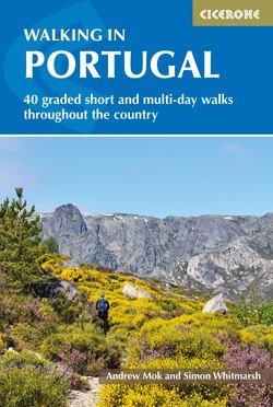
Walking along the beautiful calçada (pavement) towards Gavieira, with panoramic views of the mountain ranges of Serra da Peneda and Serra do Soajo (Walk 4)
PNPG is the only national park in Portugal. It extends between the two plateaux of Castro Laboreiro and Mourela, covering the mountain ranges of Peneda, Soajo, Amarelo and Gerês. The landscape ranges from breathtaking peaks and crags, via mountainous plateaued highland areas where livestock and wildlife graze, to lakes and waterfalls. Granite dominates the area with the presence of some metasedimentary rocks (shales) and deposits of glacial origin, such as moraines or erratic blocks.
Due to its diverse environment, the park provides habitats for a wide variety of wildlife including the roe deer (the emblem of the park), wolves and golden eagles. Serra do Gerês lilies are not found anywhere else in the world.
The list of highlights in the park is endless and includes the ethereal Sanctuary of Peneda (Walk 3), the megalithic monuments in Mezio (near Walk 5), the Via Nova Roman road (Walks 8 and 9), and a castle with superb panoramic views in Castelo Laboreiro (Walk 2).
The park’s scenery, cultural heritage, history and architecture can be explored on the walks in this chapter; alternatively you could focus on conquering the highest peaks of each mountain range – Louriça (1359m, Amarelo), Pedrada (1416m, Soajo; Walk 5), Carris (1508m, to look at the unattainable Pico da Nevosa in Gerês; Walk 7) and Peneda (1374m, Peneda).
There are five park gates with visitor centres providing advice: Lamas de Mouro, Mezio, Lindoso, Campo do Gerês and Montalegre.
View of the village Gavieira at the bottom of the valley of Rio Pomba with the majestic mountain ranges of Serra da Peneda and Serra do Soajo in the background (Walk 4)
Bases
Both Campo do Gerês and Villa do Gerês are at the park’s geographical centre and have multiple accommodation options – although as the park is so large, driving distances for the outer walks will be up to 1½hrs. Many of the walks have both dining options and rooms available at the start town/village: Castro Laboreiro for Walk 2, Peneda and Branda da Aveleria for Walk 3, and Pitões das Júnias – the highest village in Portugal – for Walk 6.
WALK 1
Caminho dos Mortos, Real
| Start/Finish | Capela do Senhor dos Passos, near Real (N42°00.658’ W08°22.938’) |
| Distance | 12.5km |
| Total ascent | 650m |
| Grade | Medium |
| Time | 5hrs |
| Terrain | Mostly along old ways, uneven in places, a little bit of tarmac |
| Map | Adventure Maps Peneda-Gerês; Carta Militar 1:50,000 sheets 1-1 and 1-2, 1:25,000 sheets 3 and 8 |
| Access | On the M503-1 between Merufe and Tangil |
| Parking | At start |
| Warning | Caution is required after heavy rain as the route crosses a number of streams, and in many places the water rushes along the calçada (stone-built pavement). |
Caminho dos Mortos – ‘Walk of the dead’ – is a superb route despite its macabre origins. It follows the old ways, along which the dead used to be transported in ox-drawn carts to church for burial: if you look closely the ruts from the cart wheels are still visible. There is also a Neolithic burial mound now almost subsumed into the landscape.
The route goes through beautiful countryside, a couple of small villages, and in many places follows watercourses. Short enough to be completed before the heat becomes too oppressive, and incorporating a reasonable amount of shade, this is a walk that could be done in summer.
From the chapel walk south on the tarmac road downhill. Take the very first right-hand fork, and then by a small chapel/shrine (Capela Sra dos Remédios) turn right to walk on a calçada, which is the actual ‘way of the dead’.
Walk upwards, over a solid stone bridge made of gigantic granite slabs, and past a beautiful old watermill, covered in moss. In spring, this whole valley is green with ferns and moss. Shortly after the mill, the path, which has been next to the river, turns to the right (where there is also a turning to the left with amazing stepping-stones).
Follow the path and 10mins later cross over the river on a bridge made from huge granite blocks. Then ford a stream and 15mins later walk underneath vines in the outskirts of the village of Arado.
The enforcado method of training vines at a height is commonly found in northern Portugal. It helps prevent fungal disease by raising the vines way above the fungal spores on the ground, which otherwise would get splashed onto the leaves by rainfall. The smallholders can also grow vegetables beneath them, an efficient use of space.
Reach a tarmac road and turn left, uphill, and then go straight over a crossroads to leave the village, heading up and south-west. Walk up the path, turn right at the large tarmac road, and then turn left in 50 metres. Go straight over a dirt road crossroads, then 350 metres after the tarmac road take a left-hand turn onto a cart track signposted for Bouças, with views of hand-built terracing down the Vale do Sucrasto.
Hand-built terracing still in use, with views down the Vale do Sucrasto
Once in the village of Bouças, turn left and then left again, staying on the tarmac road, and exit the village. After 250 metres is an acute right-hand turn: a cart track going uphill and nearly doubling backwards. Take this, and 200 metres along it take a left-hand footpath going uphill. Walk through the woods, along a path that is indistinct in places, to a farm where there is a fork. Go right, along a cart track, ignore a turning to the left and reach a T-junction. Turn right uphill, which is almost straight ahead.
Stay on this main dirt road until you reach a multi-way junction, then take the second right, counting anticlockwise, going uphill through the woods. Reach a crossroads with another cart track and turn right, signed Mamoa. After 70 metres there is a very indistinct footpath on the right signed to Mamoa do Cotinho, a large doughnut-shaped pile covered in trees.
Mamoa de Cotinho is a tumulus built around 4000BC, a collective funerary monument and a place of worship. The name means breast, and the dimple at the top shows that the structure was hollow and has now collapsed.
After exploration, retrace steps and continue down the rough, quite wide path, going straight over two crossroads with cart tracks. Some 15mins after the Mamoa, at the next crossroads, with a major dirt road (and excellent views of the valley ahead), turn left.
After 500 metres, turn right at a crossroads. Cross over a stream and take an easy-to-miss tiny footpath on the right-hand side, and then go right at the next crossroads. This footpath becomes a cart track. When the route straight ahead is so overgrown it can hardly be seen, turn left downhill, which is following the main track.
About 15mins later, at the bottom of this track, is a low wall and a T-junction with another cart track; go left here. Then at a T-junction with yet another cart track, go right. At the next T-junction go left downhill, which leads to a village called Sernades (also spelled Çernades). The route underfoot goes from cobbles to tarmac, with vines enforcado overhead.
At a T-junction in the village turn left along Caminho do Paço, and then immediately fork right downhill. Reach a T-junction and go right, again downhill. Arrive at a tarmac road, turn right and then take the first left onto a cart track adjacent to terracing and vines, just before the road loops back to Sernades. This leads to another T-junction with a cart track; go right, down the valley to a quiet tarmac road, and turn right downhill. At the end of this is a T-junction with another tarmac road; turn right, and 5mins later return to the start.
Capela do Senhor dos Passos, the start and finish point of Caminho dos Mortos
WALK 2
Trilho Castrejo, Castro Laboreiro
| Start/Finish | Igreja Matriz (main church), Castro Laboreiro (N42°01.820’ W08°09.506’) |
| Distance | 17km; including castle: 19km |
| Total ascent | 820m; including castle: 870m |
| Grade | Difficult |
| Time | 6½hrs; including castle: 7¼hrs |
| Terrain | Almost all on the old ways |
| Map | Adventure Maps Peneda-Gerês; Carta Militar 1:50,000 sheets 1-1, 1-2 and 2-4, 1:25,000 sheets 4 and 9 |
| Refreshments | Many hotels and restaurants/café in Castro Laboreiro |
| Toilets | Available near start |
| Access | From Melgaço (capital of the area), take the N202 to Lamas de Mouro, then take N202-3 to Castro Laboreiro |
| Parking | Available near start |
This highly enjoyable walk follows closely what the villagers in this remote area would have used to get from village to village – and often still do. Now designated PR3 and waymarked red/yellow, it provides panoramic views of imposing mountains, some shade here and there, and an optional visit to a Romanesque castle on the summit of Castro Laboreiro, from where you can admire the whole route.
There are streams over the path in places so this might be difficult in winter, and navigation is tricky at times, making GPS particularly useful. The route may seem a little ‘out of the way’, but its rewards are plentiful.
From the church go south past the town cross and pelourinho (pillory) to the tarmac road and turn left. You can visit the castle from here (see below), or save this until the end. Take the footpath to the right just before the new bridge and cross the impressive old bridge (Ponte Velha) with superb views of the falls with boulder-scoured cauldrons, and then rejoin the tarmac road.
The Ponte Velha (old bridge) over the Rio Laboreiro on the outskirts of Castro Laboreiro
Walk along the tarmac road for 750 metres. Be careful not to follow ‘PR Trilho Interpretativo’ on the left, then take a right-hand turn signposted for Fronteira de Ameixoeira, following red/white/yellow waymarking. After 500 metres, take a pleasant footpath on the right heading down. Ignore a turning to the left, then cross over an old bridge leading to the village of Varziela.
At a T-junction turn right, and then 50 metres later, in the outskirts of the village, fork right along an old way. This leads to a tarmac road; turn left uphill and then take the first right-hand turn following signs for Cainheiras (immediately ignore a right-hand turn going to Bico). After about 5mins arrive in Cainheiras and walk past Capela da Senhora de Numão, then go through the village following red/yellow waymarking.
Capela da Senhora de Numão was built to celebrate an apparition that appeared in the nearby cliffs, credited with numerous miracles such as saving the lives of shepherds and their animals, and the healing of mouth ulcers. In 1712 Frei Agostinho de Santa Maria, a religious writer compiling a list of holy sites of the area, said that it was so cold here in midwinter that the archbishop had to warm the Mass wine to prevent it from freezing solid.
About 500 metres out of the village, take a right-hand path off the tarmac and go over an old bridge then back onto the same tarmac road again. Take the second turning on the right 150 metres after the bridge, onto a footpath. Go up this path, then at a big fork go left and uphill. Stay on this path until the route is between two walls; go right at the next fork, leading to the village of Padrosouro. Don’t go into the village, instead fork right just before it, staying on a cart track.
Continue along this enjoyable green path, through an oak copse, to reach the outskirts of the village of Seara. Take a right-hand turn just before the village, then take the very narrow fork on the right going downhill about 100 metres after the village. Cross over a photogenic bridge; about 5mins later the path becomes a little difficult to follow – there is a very old low wall and the path crosses over it. If you miss it, the path will just peter out upwards.
Ascend between two peaks, and then the path splits into three. Take the left branch, marked by cairns (although there are many other cairns, so caution is required). Turn left at a T-junction with a cart track, leading to a wide dirt road. Go right, downhill, following red/white/yellow waymarking.
Just over 1km along this path, in a wooded area with a summit to the left, take an acutely angled rough cart track on the left-hand side, nearly doubling back on the route. After 300 metres, between two summits, go right at an indistinct fork, ascending to the top of a crest to be greeted by a remarkable view deep down into the valley ahead.
Follow this excellent footpath down the valley for about 1km to a T-junction with a rough cart track and turn left with an old stone wall to the right. The route becomes a cobbled road; go straight through the village of Curveira, cross over a tarmac road and then immediately fork left onto a cart track.
Cross over a dirt road a couple of minutes later to walk along another lovely section of footpath through an oak copse with the castle of Castro Laboreiro visible to the right. About 500 metres later, take a footpath coming off the left of the cart track. Caution is required at the end of the copse; the route to follow goes right (west) and downhill (while the footpath goes straight ahead). Go over another impressive bridge after 5mins and turn right to head upstream. Cross over another stream via a little bridge, and then go straight over a tarmac road to a footpath heading upwards.
After a couple of minutes the footpath arrives at a cobbled road; turn left and continue uphill to the village of Assureira. The cobbles become tarmac, which ends in the middle of the village. Go straight ahead down a small footpath to a pretty river. Cross the river then walk on stepping-stones on its left-hand side, heading downstream, and take the next footpath going up on the left.
After 100 metres this leads to the village of Podre, where you continue straight ahead. Reach a tarmac road, follow it and go downhill, heading north-west. Just before a concrete bridge, turn left onto a footpath through the woods, walk past an old bridge on the right and follow the river upstream, keeping it to the right.
Cross over an ancient bridge to the village of Barreiro. In the village, on a tarmac road, fork right and downhill, and then go left at a T-junction with another tarmac road. Zigzag uphill and just before a building at the end of the road, turn right onto an old way lined with a massive wall.
Follow this straight ahead and uphill for 250 metres, ignoring the many turnings, and then at a three-way fork take the middle option, which is a calçada (stone-built pavement). Cross a beautiful double stone-walled dam 500 metres later and ascend an equally beautiful footpath to reach a T-junction with a dirt road. Go right, then ignore a turning to the left (this is PR Trilho Interpretativo, also waymarked red/yellow).
The path becomes cobbled 5mins later. Enter Castro Laboreiro, go straight over the tarmac road and back onto cobbled road, and follow signs for ‘Centro’, leading back to the church where the walk began.
Castro Laboreiro as seen from the castle
To visit the castle
From the church, go south past the town cross and pelourinho to the tarmac road and turn left, then immediate right on a cobbled road, following a sign for the museum and castle. Walk up the cobbled road, past the museum to the summit (1036m) and castle.
The Romanesque castle was built in the ninth century and Iron Age remains have been found there. Later occupied by the Moors, it was then retaken by Afonso Henriques (Afonso I, the first King of Portugal) in 1144. It was the scene of many a battle and became a National Monument in 1944. (Closed Mondays and on 1 January, Easter Sunday, 1 May and 25 December.)
Return by the same route after exploring.
WALK 3
Peneda circuit
| Start/Finish | Santuário de Nossa Senhora da Peneda (N41°58.456’ W08°13.395’) |
| Distance | 24km |
| Total ascent | 1200m |
| Grade | Challenging |
| Time | 9hrs |
| Terrain | Granite stairs at the start, then proper footpath, some ancient granite shepherds’ paths, some very rough dirt tracks and a short, quiet section of tarmac road |
| Map | Adventure Maps Peneda-Gerês; Carta Militar 1:50,000 sheet 1-2, 1:25,000 sheet 9 |
| Refreshment | A selection of cafés and restaurants in Peneda; two cafés and a seasonal restaurant (July and August) in São Bento do Cando |
| Toilets | Main square in front of the sanctuary |
| Access | Follow signs on the N202 from near Soajo to Melgaço |
| Parking | Main square in front of the sanctuary |
A long walk through some of the most dramatic scenery that Portugal has to offer. It encompasses an infrequently walked hidden valley with views that have to be seen (and earned) to be believed. It also provides the opportunity to see four different brandas (summer grazing villages) and a santuário (sanctuary). The brandas are still occupied: Branda da Aveleria is the most picturesque. All this is seen from the old shepherds’ paths, hand-built from granite over millennia.
By following this route in a clockwise direction you will be heading up the steep granite steps at the beginning in the cool of the morning and mostly in shade, whereas the final section is gentler and in the afternoon is shaded by the mountain. The very last few kilometres are downhill along a road, giving your joints a rest after a day’s walking on granite.
With almost no signposting throughout – despite being a combination of the official routes of Trilho da Peneda, a small section of Pertinho do Ceu (Walk 4) and Trilho de Aveleira – this is a walk where navigation would be difficult without GPS. The very rough dirt tracks and hard granite underfoot plus an ascent of over 1000m make this a difficult yet very enjoyable experience.
The monumental flight of steps leading to Santuário de Nossa Senhora da Peneda
The santuário is an interesting architectural structure – especially the stairs leading up to it with little chapels containing sculptures of 14 stations of the cross plus six more biblical scenes such as the nativity and the last supper. According to legend, Nossa Senhora da Peneda appeared to a shepherd girl in 1220, telling the locals to build a hermitage, although the current church was not completed until 1875. The annual Feast of the Lady of Peneda is in the first week of September.
The official start of the walk is to the left of the toilet block behind the sanctuary. Walk up the well-made granite steps behind it, waymarked yellow/white/red. There is a sign for Escala da Meadinha, a climbing zone on the impressive slab of rock under which the sanctuary lies. Follow the granite steps to the top then cross the stream over a clapper bridge. Go right at a fork 100 metres after the bridge.
Arrive at a dam 1km from the start; do not cross it but follow red/white waymarking and turn left. The path then loops upwards and to the left away from the lake, rather indistinct for the next kilometre or so. This section is marked roughly with cairns, but if these have tumbled then head south from the dam, towards and through a small valley between two smooth hillocks composed of boulders, after which turn immediately right.
Next head west, with no distinguishing landmarks except the village of São Bento do Cando, visible in the distance across the valley. Follow sporadic red/white waymarking with some cairns; the path bears right across naked rock, heading north-west in the direction of some large wind turbines. Go over the crest of a hill, continuing to head north-west. After about 15mins, just before reaching a gully that blocks the route, follow the cairn-marked path as it loops round to the left and downhill. This path is manmade of vast slabs of native granite. Do not be tempted to make up your own descent; there are far too many sheer drops and impassable fractured rock fields.
Reaching the bottom of the valley, cross the Rio Pomba via some large stepping-stones. Ascend through the verdant hidden valley lined with ferns and deciduous trees for 5mins until the path arrives at an ancient drystone wall. Continue with the wall on the left side of the path, following red/white waymarking. After about 15mins the path once again becomes granite, now waymarked red/white/yellow. This leads to a wide dirt track; turn left towards the branda of São Bento do Cando.
Arrive at the branda, head straight across the tarmac road and down a cobbled road to the back of the church. There are two cafés nearby. Turn right and right again, initially heading north-west. Continue along this narrow path to arrive at a dirt cart track; turn left (uphill). The path here is variously waymarked red/white and/or red/yellow.
After 700 metres, arrive at the outskirts of Branda de Bosgalinhas and take the rough cart track heading right (the main path ahead has both yellow/red and white/red crosses). Follow this track to a gated field, then turn right along a steep uphill path between two drystone walls.
A branda is a high grazing village occupied by local people and their animals during summer. At the beginning of the colder weather they return to their inverneira – a winter village in the sheltered valley.
Verdant pastureland at Branda de Bosgalinhas
Reach a tarmac road, turn left and fork immediately right up a very steep concrete road heading south-west. This becomes a cart track, then you fork right at the next junction, with excellent views of the valley behind. Continue up the cart track, ignoring all minor turnings. There are some paddocks to the left, and a short section of granite track underfoot. Arrive at a T-junction with another dirt track after 25mins and head right (north-west); there is red/white waymarking on the left for GR Travessia das Serras da Peneda do Soajo.
Follow the dirt track for over half an hour to arrive at a major junction with a view of two sets of wind turbines. Turn left, which is north-west (the main path, which is the better travelled, heads right and east), towards some pine trees. The route winds its way briefly through a number of small pine copses, green and soft underfoot. As it heads down into Branda da Aveleira, ignore two right-hand turns (both dead-ends). At an attractively restored house called Teso da Costa, turn right and go downhill, following the main path into the village as it becomes a lovely stone-paved road.
Soon reach a T-junction with another stone-paved road, turn left and go downhill. Turn right at the next T-junction, with houses to either side, on level ground initially before quickly going downhill. Arrive at a multi-way junction with many signs for the various holiday properties nearby, and head downhill.
After about 50 metres take the unsignposted level footpath to the right of the road, heading south-east and leading to a stream. Cross over the stepping-stones, taking either of the two paths as they both go to the same place. Then take the right fork, continuing along the same path as before, with thick bushes to either side. (Ignore the left uphill fork despite it being wider and better travelled.)
About 10mins later reach a rough cart track at its hairpin bend and go left, heading uphill to a pinewood. Stay on the cart track until you reach a T-junction with another dirt track, still within the woods, and turn left, heading north-east. At the edge of the woods, arrive at a tarmac road with three options: take the middle one, going straight ahead and passing a football field to the left.
Continue on this tarmac road for 250 metres and take the next left-hand turn. This is a very quiet road only going to Branda da Bouça dos Homens. In the village, at a junction with houses called A Casrejinha ahead and O Ninho do Caçadora on the right, turn right and then turn immediately left. This is the only road out of the village and it rapidly becomes a dirt track, curving downhill.
Continue on this main dirt track for 1km, ignoring any turnings, until it meets a tarmac road. Turn right and after 20 metres go left up a beautiful granite path heading gently uphill for 1km (signposted Meadinha). The path is marked with cairns but no other waymarking.
Continue through a stunning landscape of jumbled and fractured granite for 1.5km, and then follow the path as it descends. Reach the end of this path after 1km at a large flat area and turn left along a short cobbled section which intercepts the main road. Head right and downhill for 1km to return to the santuário at Peneda.
WALK 4
Pertinho do Ceu, Gavieira
| Start/Finish | Church at Gavieira (N41°57.462’ W08°15.098’) |
| Distance | 8.5km |
| Total ascent | 600m |
| Grade | Medium |
| Time | 3½hrs |
| Terrain | All on excellent footpaths |
| Map | Adventure Maps Peneda-Gerês; Carta Militar 1:50,000 sheet 1-2, 1:25,000 sheet 9 |
| Refreshments | Cafés in São Bento do Cando, plus a seasonal restaurant (July/August only) |
| Access | Head north on the N202 from near Soajo, then drive along M503 for 600m; turn right for Gavieira |
| Parking | On road |
Pertinho do Ceu, ‘Close to heaven’, is a fittingly stunning little walk – especially satisfying if you’ve done Walk 3, as you can see its route from this one. Officially it is done clockwise, but doing it anticlockwise, as described here, makes the descent down the calçada (stone-built pavement) easier and safer.
The route includes a short section of the GR Travessia das Serra da Peneda e do Soajo, and as the name suggests, it does get very high up. Note that the route on some maps and websites is not correct – this route matches exactly the red/yellow waymarking.
From the front of the church take the only tarmac road heading uphill and north-west, and then continue heading north out of town. Rio Pomba is down in the valley on the right and there are some remarkable cliffs beyond that, on Walk 3. Take the second right-hand turn onto a footpath, approximately 700 metres from the start. Go straight over a footpath crossroads after a further 100 metres, and then fork right to go to the river. Cross the river over stepping-stones and then follow the cart track along a pretty and shaded section, walking along the valley and heading upstream.
Ford another stream (with a gate next to it) and then ascend leftwards up the slope on an indistinct path. Pass close to the right of a ruined house where the path veers right and uphill. Along this section the waymarking becomes red/yellow/white. Meet a rough cart track after 500 metres and turn left, keeping a wall to the left-hand side. Follow this track for 500 metres to São Bento do Cando.
At the village, head straight across the tarmac road and down a cobbled road to the back of the chapel.
This tiny and ancient chapel dedicated to Saint Benedict houses two holy images of him, and was an important site of religious pilgrimage. His feast day is still celebrated, although now it is more party than pilgrimage.
Turn right and right again, initially heading north-west. Continue along a narrow path, arrive at a dirt cart track and turn left (uphill). The path here is variously waymarked red/white and/or red/yellow.
After 700 metres arrive at the outskirts of Branda de Bosgalinhas and take the rough cart track heading right (the main path ahead has both yellow/red and white/red crosses). Follow this track to a gated field, then turn right along a steep uphill path between two drystone walls.
Arrive at a tarmac road a few minutes later and turn left, then fork immediately left, downhill. Follow this as it changes to concrete road through the village and past a very old thatched house. At the bottom of the village turn right onto a cart track (the main concrete road goes left). There is a paucity of waymarking along here.