Читать книгу Via Ferratas of the Italian Dolomites: Vol 2 - John Smith - Страница 19
На сайте Литреса книга снята с продажи.
ОглавлениеS.MAR 3
Sentiero Attrezzato Nico Gusella
| Grade: | 2 |
| Seriousness: | B |
| Departure point: | Ristorante Rosetta (top station of Rosetta cable car) (about 2630m) |
| Ascent: | 670m |
| Descent: | 1780m (to cable car base station at S. Martino) |
| Via ferrata: | 200m |
| Approximate time: | 7½ hours |
| Highest altitude: | 2791m, Cima di Val di Roda |
The following description assumes the use of the two-stage Col Verde Gondola and cable car from S. Martino, which is the least taxing option, but involves a long descent if you have to return to the town. Another option is to walk in from Val Canali to the south, whilst a stay in one of the three rifugios in the area (Rifs. Rosetta, Pradidali and Velo) opens up all sorts of possibilities for combining this route with others in the vicinity.
This is a pleasant and undemanding route through some of the most dramatic scenery in the Pala. Since it sits at the heart of the group, the approach and walk-out can be quite lengthy, depending on your choice of route.
The lift from S. Martino (S.MAR 1 for details) whisks you up to about 2630m in a few minutes, ensuring that for much of the rest of the day you will be walking downhill! The landscape here is extraordinary, the more so because of the speed of transition from the smart resort and the lush valley. The mural outside the building claims an altitude of 2700m, which is clearly wrong (our altimeter read 2630m).
Rif. Rosetta (2581m) is about 10 minutes’ to the north-east, reached by a good path across a real lunar landscape. From the rifugio, take path 702, signposted to Col delle Fede and Passo di Ball. This heads generally southwards, initially over fairly level ground, before starting the long descent towards Col delle Fede. The route takes the slope at an easy angle, zigzagging down endlessly, so it comes as a relief to reach a section of path (about 2265m) which is straight, as you turn in a south-easterly direction on a pleasant terrace, partly cut out of the rock face, and with an impressive drop below you to the right. A green area, full of wild flowers follows, in marked contrast to the terrain you have traversed so far. You can now pick out Passo di Ball to the south-east, a couple of hundred metres above you, whilst the walls of cliffs around the intervening bowl of mountains are quite stunning.
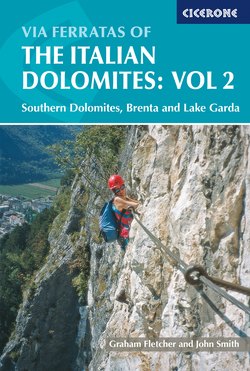
Climber on the lower part of Sentiero Gusella (S.MAR 3)
The path you have been following turns uphill towards the pass, at the junction where path 702 turns off to the right for S. Martino (at about 2285m). Your path, now numbered 715, continues straight ahead on a gently ascending traverse, soon passing an impressive perched boulder atop a pinnacle. As you approach the pass, the path climbs more steeply and (at about 2350m) reaches the start of a cable safeguarding an airy traverse. The first stretch has been cut out of the rock face, whilst the next safeguards a more gently angled area of slab. Whilst the cable is little more than a reassuring handrail, the slabs could well be iced up early in the season. You are now almost at Passo di Ball, 2443m, named after John Ball, the pioneer of many of the earliest ascents in the Dolomites.
As you approach the pass, you will notice an obvious gully, usually snow filled, a few hundred metres to its right (west). Your route is up the easily angled slabs between this gully and a second one, rather further to the right and not yet in view. Once at the pass, the path divides. Path 715 continues over the pass and heads east to Rif. Pradidali and Via Ferrata Porton (see S.MAR 4). Your path is waymarked 714 and signposted to Sentiero Nico Gusella and Cima di Val di Roda, and turns off to the right (west) just before you reach the crest of the pass. It takes about 1½ hours to reach here from the top station of the cable car.
You come to the start of the cable (at about 2545m) after about 15 minutes of easy climbing. The route climbs the easily angled rock a little to the left of a gloomy snow-filled gully. The rock is quite broken and well provided with holds, and you will make easy progress until you reach a steeper step equipped with a couple of stemples. Whilst this is straightforward, it frequently runs with water, so could be iced up early in the season. Above the step, the angle eases again as you approach the little forcella at the head of the gully on your right. A second step awaits you at the top of the area of slab: this bulges out slightly, but is easier than it looks, and takes you to the right-hand side of a smooth, easily angled slab.
There is a short break in the cable at this point, and the character of the rock changes abruptly as the sound, rounded limestone you have been climbing so far gives way to more friable rock. The cable takes you up a broken corner to the right, which is the last pitch of this, the main section of the ferrata. A few paces to your right is the floor of the upper gully, now at a more shallow angle. This might well hold some snow, but should give you no trouble in climbing up the easy angle amidst the boulders. (For climbers who are tackling the route in reverse, there is an important, but easily missed, waymark to look out for. At the point where the route traverses into the floor of the gully, a red arrow is painted on the rock wall. It is on the right side, in descent, and about 30m below the forcella. It is vital that you spot this, or you will find yourself in difficulties if you descend into the steeper middle section of the gully.) The top of the gully, which you will reach about 45 minutes after starting the route, is Forcella Stephen (about 2690m), a grand spot to have lunch and enjoy the views. About 100m above are the twin summits of Cima di Val di Roda (2791m): the round-trip only takes about 15 minutes, but the views are stunning!