Читать книгу Volcanoes: Past and Present - Edward Hull - Страница 9
На сайте Литреса книга снята с продажи.
CHAPTER III.
LINES AND GROUPS OF ACTIVE VOLCANIC VENTS.
ОглавлениеTable of Contents
The globe is girdled by a chain of volcanic mountains in a state of greater or less activity, which may perhaps be considered a girdle of safety for the whole world, through which the masses of molten matter in a state of high pressure beneath the crust find a way of escape; and thus the structure of the globe is preserved from even greater convulsions than those which from time to time take place at various points on its surface. This girdle is partly terrestrial, partly submarine; and commencing at Mount Erebus, near the Antarctic Pole, ranging through South Shetland Isle, Cape Horn, the Andes of South America, the Isthmus of Panama, then through Central America and Mexico, and the Rocky Mountains to Kamtschatka, the Aleutian Islands, the Kuriles, the Japanese, the Philippines, New Guinea, and New Zealand, reaches the Antarctic Circle by the Balleny Islands. This girdle sends off branches at several points. (See Map, p. 23.)
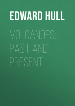
| Fig. 3.—Volcanic cone of Orizaba (Cittaltepeth), in Mexico, now extinct; the upper part snow-clad, and at its base forest vegetation; it reaches a height of 16,302 Parisian feet above the sea.—(After A. von Humboldt.) |
(a.) The linear arrangement of active or dormant volcanic vents has been pointed out by Humboldt, Von Buch, Daubeny, and other writers. The great range of burning mountains of the Andes of Chili, Peru, Bolivia, and Mexico, that of the Aleutian Islands, of Kamtschatka and the Kurile Islands, extending southwards into the Philippines, and the branching range of the Sunda Islands are well-known examples. That of the West Indian Islands, ranging from Grenada through St. Vincent, St. Lucia, Martinique, Dominica, Guadeloupe, Montserrat, Nevis, and St. Eustace,[1] is also a remarkable example of the linear arrangement of volcanic mountains. On tracing these ranges on a map of the world[2] (Map, p. 23), it will be observed that they are either strings of islands, or lie in proximity to the ocean; and hence the view was naturally entertained by some writers that oceanic water, or at any rate that of a large lake or sea, was a necessary agent in the production of volcanic eruptions. This view seems to receive further corroboration from the fact that the interior portions of the continents and large islands such as Australia are destitute of volcanoes in action, with the remarkable exceptions of Mounts Kenia and Kilimanjaro in Central Africa, and a few others. It is also very significant in this connection that many of the volcanoes now extinct, or at least dormant, both in Europe and Asia, appear to have been in proximity to sheets of water during the period of activity. Thus the old volcanoes of the Haurân, east of the Jordan, appear to have been active at the period when the present Jordan valley was filled with water to such an extent as to constitute a lake two hundred miles in length, but which has now shrunk back to within the present limits of the Dead Sea.[3] Again, at the period when the extinct volcanoes of Central France were in active operation, an extensive lake overspread the tract lying to the east of the granitic plateau on which the craters and domes are planted, now constituting the rich and fertile plain of Clermont.
Such instances are too significant to allow us to doubt that water in some form is very generally connected with volcanic operations; but it does not follow that it was necessary to the original formation of volcanic vents, whether linear or sporadic. If this were so, the extinct volcanoes of the British Isles would still be active, as they are close to the sea-margin, and no volcano would now be active which is not near to some large sheet of water. But Jorullo, one of the great active volcanoes of Mexico, lies no less than 120 miles from the ocean, and Cotopaxi, in Ecuador, is nearly equally distant. Kilimanjaro, 18,881 feet high, and Kenia, in the equatorial regions of Central Africa, are about 150 miles from the Victoria Nyanza, and a still greater distance from the ocean; and Mount Demavend, in Persia, which rises to an elevation of 18,464 feet near the southern shore of the Caspian Sea, a volcanic mountain of the first magnitude, is now extinct or dormant.[4] Such facts as these all tend to show that although water may be an accessory of volcanic eruptions, it is not in all cases essential; and we are obliged, therefore, to have recourse to some other theory of volcanic action differing from that which would attribute it to the access of water to highly heated or molten matter within the crust of the earth.
(b.) Leopold von Buch on Rents and Fissures in the Earth's Crust.—The view of Leopold von Buch, who considered that the great lines of volcanic mountains above referred to rise along the borders of rents, or fissures, in the earth's crust, is one which is inherently probable, and is in keeping with observation. That the crust of the globe is to a remarkable extent fissured and torn in all directions is a phenomenon familiar to all field geologists. Such rents and fissures are often accompanied by displacement of the strata, owing to which the crust has been vertically elevated on one side or lowered on the other, and such displacements (or "faults") sometimes amount to thousands of feet. It is only occasionally, however, that such fractures are accompanied by the extrusion of molten matter; and in the North of England and Scotland dykes of igneous rock, such as basalt, which run across the country for many miles in nearly straight lines, often cut across the faults, and are only rarely coincident with them. Nevertheless, it can scarcely be a question that the grand chain of volcanic mountains which stretches almost continuously along the Andes of South America, and northwards through Mexico, has been piled up along the line of a system of fissures in the fundamental rocks parallel to the coast, though not actually coincident therewith.
(c.) The Cordilleras of Quito.—The structure and arrangement of the Cordilleras of Quito, for example, are eminently suggestive of arrangement along lines of fissure. As shown by Alexander von Humboldt,[5] the volcanic mountains are disposed in two parallel chains, which run side by side for a distance of over 500 miles northwards into the State of Columbia, and enclose between them the high plains of Quito and Lacunga. Along the eastern chain are the great cones of El Altar, rising to an elevation of 16,383 feet above the ocean, and having an enormous crater apparently dormant or extinct, and covered with snow; then Cotopaxi (Fig. 2), its sides covered with snow, and sending forth from its crater several columns of smoke; then Guamani and Cayambe (19,000 feet), huge truncated cones apparently extinct; these constitute the eastern chain of volcanic heights. The western chain contains even loftier mountains. Here we find the gigantic Chimborazo, an extinct volcano whose summit is white with snow; Carihuairazo[6] and Illiniza, a lofty pointed peak like the Matterhorn; Corazon, a snow-clad dome, reaching a height of 15,871 feet; Atacazo and Pichincha, the latter an extinct volcano reaching an elevation of 15,920 feet; such is the western chain, remarkable for its straightness, the volcanic cones being planted in one grand procession from south to north. This rectilinear arrangement of the western chain, only a little less conspicuous in the eastern, is very suggestive of a line of fracture in the crust beneath. And when we contemplate the prodigious quantity of matter included within the limits of these colossal domes and their environments, all of which has been extruded from the internal reservoirs, we gain some idea of the manner in which the contracting crust disposes of the matter it can no longer contain.[7]
Between the volcanoes of Quito and those of Peru there is an intervening space of fourteen degrees of latitude. This is occupied by the Andes, regarding the structure of which we have not much information except that at this part of its course it is not volcanic. But from Arequipa in Peru (lat. 16° S.), an active volcano, we find a new series of volcanic mountains continued southwards through Tacora (19,740 feet), then further south the more or less active vents of Sajama (22,915 feet), Coquina, Tutupaca, Calama, Atacama, Toconado, and others, forming an almost continuous range with that part of the desert of Atacama pertaining to Chili. Through this country we find the volcanic range appearing at intervals; and still more to the southwards it is doubtless connected with the volcanoes of Patagonia, north of the Magellan Straits, and of Tierra del Fuego. Mr. David Forbes considers that this great range of volcanic mountains, lying nearly north and south, corresponds to a line of fracture lying somewhat to the east of the range.[8]
(d.) Other Volcanic Chains.—A similar statement in all probability applies to the systems of volcanic mountains of the Aleutian Isles, Kamtschatka, the Kuriles, the Philippines, and Sunda Isles. Nor can it be reasonably doubted that the western American coast-line has to a great extent been determined, or marked out, by such lines of displacement; for, as Darwin has shown, the whole western coast of South America, for a distance of between 2000 and 3000 miles south of the Equator, has undergone an upward movement in very recent times—that is, within the period of living marine shells—during which period the volcanoes have been in activity.[9]
(e.) The Kurile Islands.—This chain may also be cited in evidence of volcanic action along fissure lines. It connects the volcanoes of Kamtschatka with those of Japan, and the linear arrangement is apparent. In the former peninsula Erman counted no fewer than thirteen active volcanic mountains rising to heights of 12,000 to 15,000 feet above the sea.[10] In the chain of the Kuriles Professor John Milne counted fifty-two well-defined volcanoes, of which nine, perhaps more, are certainly active.[11] They are not so high as those of Kamtschatka; but, on the other hand, they rise from very deep oceanic waters, and have been probably built up from the sea bottom by successive eruptions of tuff, lava, and ash. According to the view of Professor Milne, the volcanoes of the Kurile chain are fast becoming extinct.
(f.) Volcanic Groups.—Besides the volcanic vents arranged in lines, of which we have treated above, there are a large number, both active and extinct, which appear to be disposed in groups, or sporadically distributed, over various portions of the earth's surface. I say appear to be, because this sporadic distribution may really be resolvable (at least in some cases) into linear distribution for short distances. Thus the Neapolitan Group, which might at first sight seem to be arranged round Vesuvius as a centre, really resolves itself into a line of active and extinct vents of eruption, ranging across Italy from the Tyrrhenian Sea to the Adriatic, through Ischia, Procida, Monte Nuovo and the Phlegræan Fields, Vesuvius, and Mount Vultur.[12] Again, the extinct volcanoes of Central France, which appear to form an isolated group, indicate, when viewed in detail, a linear arrangement ranging from north to south.[13] Another region over which extinct craters are distributed lies along the banks of the Rhine, above Bonn and the Moselle; a fourth in Hungary; a fifth in Asia Minor and Northern Palestine; and a sixth in Central Asia around Lake Balkash. These are all continental, and the linear distribution is not apparent.
[1] For an interesting account of this range of volcanic islands see Kingsley's At Last. The grandest volcanic peak is that of Guadeloupe, rising to a height of 5000 feet above the ocean, amidst a group of fourteen extinct craters. But the most active vent of the range is the Souffrière of St. Vincent. In the eruption of 1812 this mountain sent forth clouds of pumice, scoriæ and ashes, some of which were carried by an upper counter current to Barbados, one hundred miles to the eastward, covering the surface with volcanic dust to a depth of several inches.
[2] An excellent, and perhaps the most recent, map of this kind is that given by Professor Prestwich in his Geology, vol. i. p. 216. One on a larger scale is that by Keith Johnston in his Physical Atlas.
[3] Memoir on the Physical Geology and Geography of Arabia Petræa, Palestine, etc., published for the Committee of the Palestine Exploration Fund (1886), p. 113, etc.
[4] This mountain was ascended in 1837 by Mr. Taylor Thomson, who found the summit covered with sulphur, and from a cone fumes at a high temperature issued forth, but there was no eruption.—Journ. Roy. Geographical Soc., vol. viii. p. 109.
[5] Humboldt, Atlas der Kleineren Schriften (1853).
[6] Ascended by Whymper June 29, 1880. He found the elevation to be 16,515 feet.
[7] The arrangement of the volcanoes of Peru and Bolivia is also suggestive of a double line of fissure, while those of Chili suggest one single line. The volcanoes of Arequipa, in the southern part of Peru, are dealt with by Dr. F. H. Hatch, in his inaugural dissertation, Ueber die Gesteine der Vulcan-Gruppe von Arequipa (Wien, 1886). The volcanoes rise to great elevations, having their summits capped by snow. The volcano of Charchani, lying to the north of Arequipa, reaches an elevation of 18,382 Parisian feet. That of Pichupichu reaches a height of 17,355 Par. feet. The central cone of Misti has been variously estimated to range from 17,240 to 19,000 Par. feet. The rocks of which the mountains are composed consist of varieties of andesite.
[8] D. Forbes, "On the Geology of Bolivia and Southern Peru," Quarterly Journal of the Geological Society, vol. xvii. p. 22 (1861).
[9] Darwin, Structure and Distribution of Coral Reefs, second edition, p. 186.
[10] Erman, Reise um die Welt.
[11] Milne, "Cruise amongst the Kurile Islands," Geol. Mag., New Ser. (August 1879).
[12] See Daubeny, Volcanoes, Map I.
[13] Sir A. Geikie has connected as a line of volcanic vents those of Sicily, Italy, Central France, the N. E. of Ireland, the Inner Hebrides and Iceland, of which the central vents are extinct or dormant, the extremities active.