Читать книгу The Wonder Book of Volcanoes and Earthquakes - Edwin J. Houston - Страница 10
На сайте Литреса книга снята с продажи.
CHAPTER IV
THE VOLCANIC ISLAND OF ICELAND
ОглавлениеTable of Contents
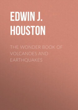
The island of Iceland consists of a number of volcanic mountains some of which are still active. As can be seen from the map, shown in Fig. 11, Iceland lies in the North Atlantic Ocean, immediately below the Arctic Circle, about 250 miles east of Greenland, and 600 miles west of Norway. Its length from east to west is about 300 miles, and its breadth about 200 miles, its total area, including the adjacent islands, being more than 40,000 square miles.
Were all the water removed from the North Atlantic Ocean, it would be seen that Iceland rests on the bed of the Atlantic, on a submarine plateau or highland; for, in this part of the ocean the water is only from 1,500 to 3,000 feet deep. This submarine plateau extends as far as Norway on the east, Greenland on the north, and the island of Jan Mayen on the northeast. Immediately north of the plateau the ocean suddenly drops to a depth of 12,000 to 15,000 feet.
Fig. 11. Iceland
Toward the south the plateau extends with but few interruptions through the middle of the ocean to a shoal known as the Dolphin Shoal, as far as lat. 25° N. This part of the ocean, which can only relatively be called a shoal, is not generally deeper than 9,600 feet, although in some places the water is more than 12,000 feet deep. On each side of the Dolphin Shoal the water is much deeper, being in places 15,000 feet on the east, while on the west there are depths as great as from 17,000 to 21,000 feet.
This sunken plateau, possibly including the shallower plateau on the north, is believed by some to be the remains of the fabled continent of Atlantis, to which we shall refer in another part of this book.
The coast line of Iceland is unbroken on the southeast, but the remainder of the coast is deeply indented with bays or fiords in which are many excellent harbors.
Iceland is liable to frequent earthquake shocks and volcanic eruptions. From careful records that have been preserved in the history of the island, we learn that since the beginning of the twelfth century there have practically never been intervals longer than forty years, and more generally not longer than twenty years, in which there has not been a great earthquake or a great volcanic eruption. These volcanic eruptions are often very protracted. For example, one eruption of the volcano Hecla continued for six years without ceasing. Sir Charles Lyell, the great English geologist, writes as follows about Iceland:
"Earthquakes have often shaken the whole island at once, causing great changes in the interior, such as the sinking down of hills, the rending of mountains, the desertion of rivers by their channels, and the appearance of new lakes. New islands have often been thrown up near the coast, some of which still exist, while others have disappeared, either by subsidences or the action of the waves.
"In the interval between eruptions innumerable hot springs afford vent to the subterranean heat, and solfataras discharge copious streams of inflammable matter. The volcanoes in different parts of the island are observed, like those of the Phlegræan Fields, Italy, to be in activity by turns, one vent often serving for a time as a safety valve for the rest. Many cones are often thrown up in one eruption and in this case they take a linear direction, running generally from southeast to northwest."
The volcanic eruptions of Iceland belong for the greater part to the fissure type. During a volcanic eruption in Iceland the ground is split in fissures or cracks, generally parallel to each other, and varying in width from a few inches to several yards. These fissures extend for great distances across the country. The lava quietly wells out along the fissures not unlike the way quiet spring waters flow from their reservoirs.
According to Dr. Th. Thoroddsen, the Icelandic geologist, there are two systems of fissures extending through Iceland, from southwest to northeast in the southern part of the island, and from north to south in the northern part. Where two lines of fissures cross each other the points of intersection may be especially active.
Dr. Th. Thoroddsen arranges the volcanoes of Iceland under three heads, i.e., cone-shaped volcanoes; lava cones; and chains of craters, the last being the commonest. Out of 107 volcanoes examined by him in Iceland, eight were of the Vesuvian type, or were built up of layers of lava and volcanic ashes; sixteen were of the lava-cone type, similar to Mt. Loa, of the Hawaiian Islands, and the remaining eighty-three were of the type of crater chains.
The volcano of Snaefell Jökul, 4,710 feet above the level of the ocean, is built up of alternate layers of lava and hardened volcanic mud. It is not, however, a true cone-shaped mountain.
The largest volcano in Iceland, the Dyngjufköll, with its immense crater of Askja, has an area of some twenty-five square miles. In its form it resembles Snaefell.
Volcanoes of the lava-cone type have been built up entirely of lava and have a slight angle of inclination. These volcanoes range in size from small hillocks to the largest mountains on the island. Their cones generally stand on a base of wide circumference and frequently rise to great heights, the top being occupied by a caldera, or pit crater like that on Mt. Loa or Kilauea.
Volcanoes of the type of chain-craters follow the natural fissures in the crust. These craters are generally low, seldom being more than 350 feet high.
There are also seen in Iceland caldron-shaped depressions that have been formed by explosive eruptions. One of the best instances of such craters is Viti, on the side of Mt. Krafla. This crater was formed by the sudden eruption of May 17th, 1724.
The lava sometimes quietly runs out of the entire length of the fissure without forming any cone. This was the case of a great fissure known as the Eldgja Chasm. Here three lava streams covered an area of 270 square miles.
As the lava comes out of the fissures, it generally produces long ramparts of slags, and blocks of lava that are piled up on either side of the fissure. Sometimes a line of low cones is built up. These cones consist of heaps of slag, cinders, and blocks of lava. Their craters are not rounded as in the case of volcanoes of the Vesuvian type, but are oblong, or have their greatest diameter extending in a direction of the fissure.
Icelandic lava as it escapes from the fissures is peculiar in that it is very viscid or plastic and can be readily drawn out into long threads that can be spun into ropes. When such lava runs down the sides of a steep slope, it often splits on cooling into separate blocks. Where it runs over flat, level ground, however, it spreads uniformly on all sides, producing vast level lava deserts that are as flat as the surface of a well built floor.
There are many rivers in the north and the west of Iceland. Now, as the lava streams flow out of the fissures they enter the channels of the rivers so that the streams of water must find new paths to the sea, and this operation may be repeated again and again. Often the time between eruptions is long enough to give the rivers opportunity to cut deep channels or gorges in their new channels; but on the next escape of the lava these gorges and valleys are again filled with the molten rock, and the rivers must begin their channel cutting all over.
You will note the frequent use of the word Jökul, as Snaefell Jökul, Skaptar Jökul, Orefa Jökul, etc. The name Jökul means a large mass of ice, or a mountain that is continually covered with snow, for example, Snaefell Jökul, is a beautifully shaped, snow-covered mountain situated on a point of land on the western coast of the island, extending out nearly fifty miles into the sea, between the Faxa Fiord and the Briela Fiord. It is a very conspicuous object, being visible to passing ships at considerable distances from the island. Orefa Jökul is the highest mountain in Iceland. Skaptar Jökul is one of the active volcanoes of Iceland.
There can be no doubt that Iceland has been formed entirely by lava thrown up from the bottom of a submarine plateau, until it extended above the surface of the waters. To make an island entirely of lava with an area of 40,000 square miles, must, of course, have required many cones or craters that continued to pour forth lava for periods of time much longer than those during which man has lived on the earth.
The surface of Iceland is far from attractive. The interior is practically a vast lava desert, covered with snow-clad mountains or Jökuls. There is no plant life except in marshy lands near the coasts, and even here scarcely enough grass is raised to feed the few cattle and horses owned by the inhabitants. There is no agriculture, owing to the very short summers, so that all grain is brought from Europe. Every now and then the grass crop is destroyed by accumulation of Polar ice on the northern and western coasts. Such failures are always attended by great famines, when many of the people die.
Should you ever visit Iceland you would probably be surprised to hear the people speaking about their forests. You might go over all the coasts of the island without seeing anything larger than a birch bush, not much higher than six feet. These are what the Icelanders like to speak of as their forest trees, and I suppose there is no harm done, if one only understands just what they mean by "trees."
While, however, Iceland has practically no trees, yet it has no difficulty in obtaining a plentiful supply of timber, since in the deep fiords or bays on the western and southern coasts there can always be found much drift timber brought there by the ocean currents from the forests of America.
The principal town or settlement in Iceland is Reykjavik, the capital of the island, on the southwestern coast; this is the chief trading place on the island. Thingvalla is also an important town.
The lavas that form the entire mass of Iceland were thrown out both before and since the glacial age. It is the opinion of Geikie that these outflows have continued uninterruptedly since that age to the present time. It is known that the lavas of Iceland were thrown out both before and after the glacial age, because during the glacial age, deep cuttings or groovings were made on the surface of the earth by the glaciers as they slowly moved over it. Now lava beds containing the glacial scratches have been found and resting on them are other lava streams. The scratched lavas must, therefore, have been thrown out before the glacial age, and the second lavas after that age.
Let us now examine some of the more active volcanoes of Iceland and their eruptions. We will begin with the well-known volcano of Skaptar Jökul.
The following description of this volcano has been taken from a book on Iceland by E. Henderson, published in Boston, 1831. Skaptar Jökul lies in the south central part of Iceland about forty odd miles from the coast. It takes its name from the Skaptar River, down whose channel the lava flowed its entire distance of forty miles from the ocean. Skaptar Jökul consists of about twenty conical hills lying along one of the fissures that extends from northeast to southwest.
It appears from Henderson's account that people living in the neighborhood of Skaptar Jökul were greatly alarmed by repeated earthquakes that were felt at different times from the first to the eighth of June, 1783. These earthquake shocks increased in number and violence, so that the people left their homes and awaited in terror the coming catastrophe. On the morning of the eighth a prodigious cloud of dense smoke darkened the air, and the surrounding land soon became covered with ashes, pumice, and brimstone. As is common with eruptions in Iceland, that have been preceded by long periods of rest, the heat produced by the escaping lava and the sulphurous gases, melted such quantities of ice that great floods were produced in the rivers.
On the 10th of June vast torrents of lava that had been escaping from the craters entered the valley of the Skaptar River, and commenced flowing through its channel. Immense quantities of steam were produced, and, in less than twenty-four hours, the river was completely dried up, for the lava had collected in the channel, which in many places flows between high rocks from 400 to 600 feet in height and nearly 200 feet in breadth, and had not only filled the river to its brink, but had overflowed the adjacent fields to a considerable extent, and flowing along the cultivated banks of the river destroyed all the farms in its path.
On gaining the outlet, where the channel of the Skaptar emerged into the plain, it might have been supposed that the burning flood would have at once spread over the low fields, which lay immediately before it, but, contrary to all expectations, this flow was for a time stopped by an immense unfathomed abyss in the river's bed, into which it emptied itself with great noise. When this chasm was at last filled, the lava increased by fresh flows, rose to a prodigious height, and breaking over the cooled mass, proceeded south towards the plain.
In the meantime the thunder and lightning, together with subterranean roars, continued with little or no intermission.
On the 18th of June, 1783, another dreadful eruption of red hot lava came from the volcano. This flowed with great velocity and force over the surface of the cooling stream that had been thrown out principally on the tenth of the month. Floating islands consisting of masses of flaming rock were seen on the surface of the lava stream, and the water that had been banked up on both sides of the stream was thrown into violent boiling.
In the meantime people living along the Hverfisfloit, the next largest river to the east of the Skaptar, had not yet been visited by the lava streams. It is true that their vegetation had been destroyed by showers of red hot stone and ashes, and that both atmosphere and water were filled with poisonous substances. The land had also been plunged in utter darkness, so that it was scarcely possible at noonday to distinguish a sheet of white paper held up at the window from the blackness of the wall on either side. But the molten lava streams had not yet reached the people of this valley and they hoped that the eruption would soon be over, and that the lava flow would continue to follow the Skaptar. On the 3d of August, however, they were alarmed by seeing steam escaping from the River Hverfisfloit, and soon all its water was dried up, and a fresh lava flow poured down upon them. As in the case of the Skaptar, the melted rock completely filled the empty channel to the brink, and then overflowing, covered the low grounds on both sides, so that by the ninth of August it had reached the open and level country near its mouth and in the course of a few hours spread itself for a distance of nearly six miles across the plain. This flow continued after the end of August, and, indeed, even as late as the month of February, 1784, when a new eruption took place in this part of the country.
Hecla, another well-known volcano in Iceland, situated about thirty miles from the southern coast, consists of three peaks, the central of which is the highest. Its craters form vast hollows on the sides of these peaks, and at the time of the eruption in 1766 were covered with snow. Hecla is believed to have been an active volcano long before Iceland was inhabited. No less than twenty-three eruptions have been recorded between a. d. 1004 and the great eruption of 1766–68.
Volcanic history frequently repeats itself. There had been no great eruption of Hecla for a period of about twelve years, and the people living in the neighborhood were congratulating themselves on the belief that the mountain was becoming actually extinct, and that therefore they need not trouble themselves about eruptions. Others, however, more farseeing, pointed out the fact that the lakes and rivers in the vicinity did not freeze, and that the amount of water they contained was greatly decreased.
The following description of the great eruption of Hecla that was remarkable both for its violence, as well as for the time during which it continued, is taken from Symington's "Sketches of Faroe Islands and Iceland":
"On the 4th of April, 1766, there were some slight shocks of an earthquake, and early next morning a pillar of sand, mingled with fire and red hot stones, burst with a loud thundering noise from its summit. Masses of pumice, six feet in circumference, were thrown to the distance of ten or fifteen miles, together with heavy magnetic stones, one of which, eight pounds weight, fell fourteen miles off, and sank into ground still hardened by the frost. The sand was carried towards the northwest, covering the land, 150 miles round, four inches deep, impeding the fishing boats along the coast, and darkening the air, so that at Thingore, 140 miles distant, it was impossible to know whether a sheet of paper was white or black. At Holum, 155 miles to the north, some persons thought they saw the stars shining through the sand-cloud. About mid-day, the wind veering round to the southeast, conveyed the dust into the central desert, and prevented it from totally destroying the pastures. On the 9th of April, the lava first appeared, spreading about five miles towards the southwest, and on the 23d of May, a column of water was seen shooting up in the midst of the sand. The last violent eruption was on the 5th of July, the mountains, in the interval, often ceasing to eject any matter; and the large stones thrown into the air were compared to a swarm of bees clustering around the mountain-top; the noise was heard like loud thunder forty miles distant, and the accompanying earthquakes were more severe at Krisuvik, eighty miles westward, than at half the distance on the opposite side. The eruptions are said to be in general more violent during a north or west wind than when it blows from the south or east, and on this occasion more matter was thrown out in mild than in stormy weather. Where the ashes were not too thick, it was observed that they increased the fertility of the grass fields, and some of them were carried even to the Orkney Islands, the inhabitants of which were at first terrified by what they considered showers of black snow."
The largest volcano in Iceland is Dyngjufjoll. This has on its summit the gigantic crater of Askja, some twenty-five square miles in area. This crater is of the intermediate form; the most general form of volcanoes on the island consisting of a number of craters that closely follow fissures.
Professor Johnstrup, in a report to the Danish Government, on this volcano, states that the valley of Askja has been gradually filled by repeated flows of lava from enormous craters on the edge of the mountain. In many places the surface of the earth is covered with bright red pumice stone that was thrown out during an eruption March 29th, 1875. Some of these craters are filled with steam that escapes with an almost deafening roar. The surprising feature of this eruption was the immense quantity of pumice stone that escaped.
The volcanoes in the Nyvatus Oraefi are entirely different. This barren plain is thirty-five miles in length and thirteen miles in breadth. Suddenly on the 18th of February, 1875, a volcano appeared in the centre, and four other craters were formed at subsequent dates. The mass of lava that was thrown out of these openings has been estimated at 10,000,000,000,000 cubic feet, or eighteen times the estimated mass of lava that has been emitted from Vesuvius between 1794 and 1855. This lava is basalt.