Читать книгу Commercial Geography - Jacques W. Redway - Страница 12
На сайте Литреса книга снята с продажи.
TOPOGRAPHIC CONTROL OF COMMERCE
ОглавлениеTable of Contents
The great industry of commerce, which includes both the trade in the commodities of life and the transportation of them, is governed very largely by the character of the earth's surface. But very few food-stuffs can be grown economically in mountain-regions. Steep mountain-slopes are apt to be destitute of soil; moreover, even the mountain-valleys are apt to be difficult of access, and in such cases the cost of moving the crops may be greater than the market value of the products. Mountainous countries, therefore, are apt to be sparsely peopled regions.
But although the great mountain-systems are unhabitable, or at least sparsely peopled, they have a very definite place in the economics of life. Thus, the great western highland of the United States diverts the flow of moisture from the Gulf of Mexico northward into the central plain, and gives to the region most of its food-growing power. In a similar manner, moisture intercepted by the Alps and the Himalayas has not only created the plains of the Po and the Ganges from the rock-waste carried from the slopes, but has also made them exceedingly fertile.
Mountain-ranges are also valuable for their contents. The broken condition of the rock-folds and the rapid weathering to which they are subjected have exposed the minerals and metals so useful in the arts of commerce and civilization. Thus, the weathering of the Appalachian folds has made accessible about the only available anthracite coal measures yet worked; and the worn folds about Lake Superior have yielded the ores that have made the United States the foremost copper and steel manufacturing country of the world. Gold, silver, tin, lead, zinc, platinum, granite, slate, and marble occur mainly in mountain-folds.
Mountains and Valleys.—Mountain-ranges are great obstacles to commerce and intercommunication. The Greek peoples found it much easier to scatter along the Mediterranean coast than to cross the Balkan Mountains. For twenty years after the settlement of California, it was easier and less expensive to send traffic by way of Cape Horn than to carry it across the Rocky Mountains.
The deep cañons of mountainous regions are quite as difficult to overcome as the high ranges. In modern methods of transportation a range that cannot be surmounted may be tunnelled, and a tunnel five or six miles in length is no uncommon feat of engineering. A cañon, however, cannot be tunnelled, and if too wide for cantilever or suspension bridges, a detour of many miles is necessary. In crossing a deep chasm the route of transportation may aggregate ten or fifteen times the distance spanned by a straight line.
Excepting the mining regions, the population of mountainous countries is apt to be found mainly in the intermontane valleys. A reason for this is not hard to find; the valleys are usually filled with rich soil brought from the higher slopes and levelled by the water. The population, therefore, is concentrated in the valley because of the food-producing power of the land. For this reason the Sound, Willamette, and San Joaquin-Sacramento Valleys contain the chief part of the Pacific coast population. The Shenandoah and the Great Valley of Virginia are similar instances.
What is true of the larger intermontane valleys is true also of the narrow stream valleys of mountain and plateau regions. Thus, in the New England plateau the chief growth during the past forty years has been in the valley lands. In that time if the uplands have not suffered actual loss, they certainly have made no material gains. Upland farming has not proved a remunerative venture, and many of the farms have either been abandoned or converted to other uses.
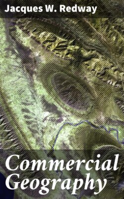
Passes.—Transverse valleys form very important topographic features of mountain-regions. Inasmuch as the ranges themselves are obstacles to communication, it follows that the latter must be concentrated at such cross valleys or gaps as may be traversed. Khaibar Pass, a narrow defile in the Hindu Kush Mountains, between Peshawur and Jelalabad, for many years was the chief gateway between Europe and India. Even now the cost of holding it is an enormous tax upon England.
Brenner, St. Gotthard, and the Mont Cenis Passes are about the only land channels of commerce between Italy and transalpine Europe, and most of the communication between northern Italy and the rest of Europe is carried on by means of these passes. Every transcontinental railway of the American continent crosses the various highlands by means of gaps and passes, and some of them would never have been built were it not for the existence of the passes. Fremont, South, and Marshall Passes have been of historic importance for half a century.
The Hudson and Champlain Valley played an important part in the history of the colonies a century before the existence of the United States, and its importance as a gateway to eastern Canada is not likely to be lessened. The Mohawk gap was the first practical route to be maintained between the Atlantic seaboard and the food-producing region of the Great Central Plain. It is to-day the most important one. It is so nearly level that the total lift of freight going from Buffalo to tide-water is less than five hundred feet.
A PASS—THE ROUTE OF A RAILWAY
Rivers.—River-valleys are closely connected with the economic development of a country. Navigable rivers are free and open highways of communication. In newly settled countries the river is always the least expensive means of carriage, and often it is the only one available for the transportation of heavy goods.
In late years, since the railway has become the chief means for the transportation of commodities, river transportation has greatly declined. The river-valley, however, has lost none of its importance; in most instances it is a naturally levelled and graded route, highly suitable for the tracks of the railway. As a result, outside of the level lands of the Great Central Plain, not far from eighty per cent. of the railway mileage of the United States is constructed along river-valleys.
Plateaus.—Plateaus are usually characterized by broken and more or less rugged surface features. As a rule they are deficient in the amount of rainfall necessary to produce an abundance of the grains and similar food-stuffs, although this is by no means the case with all.
Most plateaus produce an abundance of grass, and cattle-growing is therefore an important industry in such regions. Thus, the plateaus of the Rocky Mountains are famous for cattle, and the same is true of the Mexican and the South American plateaus. The Iberian plateau, including Spain and Portugal, is noted for the merino sheep, which furnish the finest wool known. The plateau of Iran is also noted for its wool, and the rugs from this region cannot be imitated elsewhere in the world.
Plains.—Plains are of the highest importance to life and its activities. Not only do they present fewer obstacles to intercommunication than any other topographic features, but almost always they are deeply covered with the fine rock-waste that forms the chief components of soil. Plains, therefore, contain the elements of nutrition, and are capable of supporting life to a greater extent than either mountains or plateaus. About ninety per cent. of the world's population dwell in the lowland plains.
The Great Central Plain of North America produces more than one-quarter of the world's wheat, and about four-fifths of the corn. The southern part of the great Arctic plain, and its extension, the plains of the Baltic also yield immense quantities of grain and cattle products. The coast-plains of the Atlantic Ocean, on both the American and the European side, are highly productive.
River flood-plains are almost always densely peopled because of their productivity. The bottom-lands of the Mississippi and the Yangtze Rivers are among the chief food-producing regions of the world. Lacustrine plains, the beds of former lakes, are also highly productive regions. The valley of the Red River of the North is an example, and its wheat is of a very high quality.
Fertile coast-plains and lowlands that are adjacent to good harbors, as a rule are the most thickly peopled regions of the world. In many such regions the density of population exceeds two hundred or more per square mile. The reason is obvious. Life seeks that environment which yields the greatest amount of nutrition with the least expenditure of energy.
The study of a good relief map shows that, as a rule, the Pacific Ocean is bordered by a rugged highland, which has a more or less abrupt slope, and a narrow coast-plain. Indeed, the latter is absent for the greater part. The slopes of the Atlantic, on the other hand, are long and gentle—being a thousand miles or more in width throughout the greater part of their extent. The area of productive land is correspondingly great, and the character of the surface features is such that intercommunication is easy.
A RIVER FLOOD-PLAIN—A REGION ADAPTED TO CULTIVATION
The result of these conditions is evident. The Atlantic slopes, though not everywhere the most densely peopled areas, contain the great centres of the world's activities and economies. In the past 400 years they have not only overtaken the Pacific coast races, but have far surpassed them. They are now entering upon a commercial invasion of the Pacific nations that is resulting in a reorganization of the entire industrial world.
Topography and Trade Routes.—As the settlement and commerce of a country grow, roads succeed trails, and trails are apt to follow the paths of migrating animals. Until the time of the Civil War in the United States, most of the great highways of the country were the direct descendants of "buffalo roads," as they were formerly called.
In the crossing of divides from one river-valley to another, the mountain-sections of the railways for the greater part follow the trails of the bison. This is especially marked in the Pennsylvania, the Baltimore and Ohio, and the Chesapeake and Ohio railways; in some instances the tunnels through ranges have been constructed directly under the trails. The reason is obvious; the instinct of the bison led him along routes having the minimum of grade.
Throughout the Mississippi Valley and the great plains the Indian trails usually avoided the bottom-lands of the river-valleys, following the divides and portages instead. This selection of routes was probably due to the fact that the lowlands were swampy and subject to overflow; the portages and divides offered no steep grades, and were therefore more easily traversed.
WHERE COMMODITIES ARE EXCHANGED—NEW YORK CITY WATER-FRONT
Harbors.—Coast outlines have much to do with the commercial possibilities of a region. The "drowned valleys" and similar inlets along the North Atlantic coast, both of Europe and America, form harbors in which vessels ride at anchor in safety, no matter what the existing conditions outside may be. As a result, the two greatest centres of commerce in the world are found at these harbors—one on the American, the other on the European coast.
From New York Bay southward along the Atlantic seaboard there are but few harbors, and this accounts for the enormous development of commerce in the stretch of coast between Portland and Baltimore. San Francisco Bay and the harbors of Puget Sound monopolize most of the commerce of the Pacific coast of the United States. South America has several good harbors on the Atlantic seaboard, and in consequence a large city has grown at the site of each. On the Pacific coast the good harbors are very few in number, and they are not situated near productive regions.
Asiatic peoples, as a rule, are not promoters of foreign commerce, and, those of Japan excepted, the only good harbors are those that have been improved by European governments. These are confined mainly to India and China. The many possible harbors make certain a tremendous commerce in the future. Africa has but very few good harbors. There are excellent harbors in the islands of the Pacific, and many of them are of great strategic value as coaling stations and bases of supply to the various maritime powers.
QUESTIONS FOR DISCUSSION
The Pennsylvania Railroad has found it more economical to tunnel the mountain-range under Horseshoe Curve, near Altoona, than to haul the trains over the mountains; discuss the details in which there will be a saving.
Why are rugged and mountainous regions apt to be sparsely peopled?
The first valuable discovery in the Rocky Mountains was gold; what were the chief effects that resulted?
Would the industries of the Pacific coast of the United States be benefited or impaired by the existence of a coast-plain?
Which are more conducive to commerce—the large mediterraneans, such as the Gulf of Mexico, or the small estuaries, such as New York Bay? Discuss the merits or demerits of each.
What are the chief products of mountains, of plateaus, of lowland plains?
COLLATERAL READING AND REFERENCE
Adams's New Empire—Chapter I.
Redway's Physical Geography—Chapter IV.
A topographic map of the United States.
MEAN ANNUAL RAINFALL