Читать книгу The Mountains of Nerja - Jim Ryan - Страница 10
На сайте Литреса книга снята с продажи.
ОглавлениеWALK 1
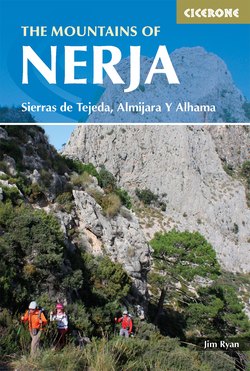
Frigiliana to the Cave of Nerja
| Start | Plaza Ingenio, Frigiliana |
| Finish | The Cave of Nerja |
| Distance | 15km (as far as the east side of Nerja); 18km including the extension to La Presa dam; 11km taking the shortcut to El Pinarillo |
| Difficulty | 3 |
| Time | 5½ hrs; 6hrs including the dam; 4½ hrs taking the shortcut |
| Height gain | 600m |
| Getting to the start | The most practical way of getting to the start of this walk is to take a bus from Nerja to Frigiliana. Regular buses leave the bus station at the top of the town and, 15 minutes later, arrive at the main square, Plaza Ingenio, in Frigiliana. |
This walk would make a good first excursion for getting a feel for the features and landmarks of the Nerja area. It crosses two rivers and skirts under some of the region’s high peaks.
One of the Junta de Andalucía’s waymarked walks, this route is maintained and easy to follow. It is an undulating and rough walk and a little steep in places. The first river crossing is unlikely to cause any difficulty, but the second may be ankle deep if the weather has been wet.
The ancient village of Frigiliana has a chequered past and was the centre for many industries over its history. Artefacts unearthed here include 3000-year-old Neolithic remains as well as Roman coins. It was a Moorish enclave for centuries and the scene of a bloody battle in 1569.
High up on the mountain of El Fuerte above the village there are the remains of two lime kilns, an indication of the old industry of producing mortar and whitewash; the large old building on the main square, El Ingenio, The Engine, referred to the sugar factory that existed here from the early 17th century; the tourist office itself, Casa del Apero, the house of the farm implements, is 15th century.
The ceramic plaques of Frigiliana are most interesting and feature in Walk 2.
If you stand in the square facing the obvious tall building, you will see a decorative kiosk in the foreground. Behind the kiosk and off to the left is the stone path up to the centre of the old town. To the right, the stepped path in the opposite direction leads to the tourist office at Casa Del Apero. In between these two opposing directions there is an alleyway with signs for the Rio Higueron, and this is the route.
The walk descends a steep concrete path down to the river bed. Just short of it there is a kerbed path on the left. Turn off onto this path. This is a disused concrete water channel, a regular feature of walks in this area, and following this instead of the river should keep your feet dry.
Going left against the flow of the Rio Higueron, the route passes by a reservoir and a grove of gum trees and presently arrives at the river crossing. (The river is usually a trickle here.)
Fringed pinks
There is a noticeboard, typical of all of the waymarked walks, here. It says that the distance is 6.3km; it will take three hours and the difficulty is medium (time and distance are one way and only as far as the Fuente del Esparto; it is quite a few kilometres further to Nerja). It says to take good boots and that the walk may be dangerous in winter when the mountains may suddenly be enveloped in cloud. It also describes the wonders of the gorges of the Rio Chillar and it suggests looking out for eagles and peregrine falcons in the skies. The advice is not to drink the water from either of the rivers.
Walkers on the trail rising up from the river