Читать книгу Ancient Scottish Lake-Dwellings or Crannogs - Robert Munro - Страница 7
На сайте Литреса книга снята с продажи.
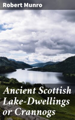
ОглавлениеFig. 10.—Caldron found in Carlingwark Loch.
A large bronze caldron, found by Mr. Samuel Gordon and J. T. Blackley while fishing near the Fir Island, and dredged out of the loch, contained a large number of iron and bronze implements (Fig. 10). When this caldron was raised, it was shining like gold. Mr. Gordon thinks it was left by Edward I., who had a camp on the Fir Island, and that it was deposited to prevent the Gallovidians getting any metal in their possession. A bronze sword was also found in this Loch, which is now in the National Museum, Scotland.—(Proc. Soc. Antiq. Scot. vol. vii. p. 7; and x. p. 286.)
Loch Spinie, Morayshire.
"Near it (the Bishop's Palace), where the water is deepest, a small artificial island emerged, upon clearing out the canal, of an oval form, about 60 by 16 paces, appearing to be composed of stones from the quarry, bound together by crooked branches of oak, and as if the earth, with which it was completed, had been wholly washed off during its submersion."—(Old Stat. Account, vol. x. p. 625.)
Loch of Boghall, Beith, Ayrshire.
"In the map of Cunninghame in Bleau's Atlas, published in 1654, there is laid down a piece of water called the Loch of Boghall. This loch belonged to the Monastery of Kilwinning, and was of old called Loch Brand. In the Acta Dominorum Concilii there is mention made of a case, 10th December 1482, at the instance of the Abbot and Convent of Kilwinning against, etc. etc., who were accused of the dangerous destruction and down-casting of the fosses and dikes of the Loch called Loch Brand. … The loch was drained about sixty years ago, when firm stakes of oak and elm were found in the soil, and which had been used for fixing the nets for fishing."—(New Stat. Account, vol. v. p. 580.)
Parish of Culter, Lanarkshire.
"In the midst of a morass, half a mile north-east from the farm of Nisbet, may be seen a very singular remnant of antiquity. A mound of an oval shape, called the Green Knowe, measuring about 30 yards by 40, rises about two or three feet above the surface of the surrounding bog. On penetrating into the elevating mass, it is found to consist of stones of all different kinds and sizes, which seem to have been tumbled promiscuously together without the least attempt at arrangement. Driven quite through this superincumbent mass are a great number of piles, sharpened at the point, about three feet long, made of oak of the hardest kind, retaining the marks of the hatchet, and still wonderfully fresh. A causeway of large stones connects this mound with the firm ground."—(New Stat. Account, vol. vi. p. 346.)
Loch Rannoch, Perthshire.
"There are two small islands situate in the upper end of the lake. The east and large one is wholly artificial, resting upon large beams of wood fixed to each other. This island was sometimes used as a place of safety in cases of emergency; at other times, as a place of confinement for such as rebelled against or offended the chief. To this retreat there is a road from a point on the south side—which road is always covered with 3 or 4 feet of water, is very narrow, and has a great depth on both sides of it."—(New Stat. Account, vol. x. p. 539.)
Parish of Croy, Inverness-shire.
"In draining a lake at the east-end of the parish, an artificial mound appeared within a few yards of the shore, about 60 feet in circumference, and 5 feet in height. It was formed of alternate strata of stones, earth, and oak; piles of oak being driven in the ground were kept strongly fixed by transverse beams of smaller size. Over these were round stones, and on the surface some inches of fine black mould. Some fragments of brass rings, pieces of potteries, and the bolt of a lock, of no ordinary size, were found on the mound.
"At about 100 yards' distance there is a circle of large piles of oak, driven deep in the earth, apparently the commencement of a second mound; but for what purpose they were intended it is impossible to conjecture. They could not be places of defence, as the one finished was so near the edge of the lake, and completely commanded by the opposite rising bank. While draining the lake by cutting a deep canal, oaks of gigantic size were found more than 20 feet below the surface, as sound as the day they were overwhelmed by water, sand, and gravel. At the same time a canoe of most beautiful workmanship was found, which some modern Goth has since cut down for mean and servile purposes."—(New Stat. Account, vol. xiv. p. 448.)
Lochs of Kinellan and Achilty, Contin, Ross-shire.
"In Lake Kinellan stands an artificial island, resting upon logs of oak, on which the family of Seaforth had at one period a house of strength. … There is still in Loch Achilty a small island, likewise supposed to be artificial. It belonged to Mac Lea Mor, i.e. Great Mac-Lea, who possessed at the same time a large extent of property in the parish; and who was wont, in seasons of danger, to retire to the island as a place of refuge from his enemies. The ruins of the buildings which he there occupied may still be traced."—(New Stat. Account, vol. xiv. p. 238.)
Loch Cot, Parish of Torphichen.
"The loch lies at the foot of the southern slope of Bowden Hill, and is now drained. An old man who belonged to Dr. Duns's (New College, Edinburgh) congregation when he was at Torphichen, more than once described to him the appearance of the loch before it was drained—'its central island, and the big logs taken from it and burned.' Horns were also found in the loch, but were neglected, and have disappeared. Dr. Duns found part of a quern on an examination of the site; and on digging into a mound at a short distance eastward from the loch, he found an urn of rude type. To the south are the remains of a circular earthwork; and to the south-west, traces of what has been called a Roman camp; and to the south, a camp of peculiar form, noticed by Sibbald."—(Dr. Stuart's article, Proc. Soc. Antiq. Scot. vol. vi.)
Castle Loch, Lochmaben.
In the Castle Loch of Lochmaben is a small artificial island now sunk several feet under the water, from which during dry weather on several occasions some of the oak mortised beams have been fished up.
Loch Lochy, Inverness-shire.
Dr. Stuart quotes the following account of a crannog in Loch Lochy from Mr. Robertson's notes, extracted by the latter from a ms. in the Advocates' Library, written towards the end of the seventeenth century. "Ther was of ancient ane lord in Loquhaber, called my Lord Cumming, being a cruell and tyirrant superior to the inhabitants and ancient tenants of that countrie of Loquhaber. This lord builded ane iland or an house on the south-east head of Loghloghae; … and when summer is, certain yeares or dayes, one of the bigge timber jests, the quantitie of an ell thereof will be sein above the water. And sundrie men of the countrie were wont to goe and se that jest of timber which stands there as yett; and they say that a man's finger will cast it too and fro in the water, but fortie men cannot pull it up, because it lyeth in another jest below the water."—(Proc. Soc. Antiq. Scot. vol. vi. p. 160.)
Loch Lomond.
Regarding a crannog in Loch Lomond,[16] in the neighbourhood of a stone cashel on shore, from which large mortised joists were disjoined in 1714, and used by a gentleman in that country for building a house, see extracts from Dr. Robertson's notes, Proc. Soc. Antiq. Scot. vol. vi. p. 132.
Loch of the Clans, Nairnshire.
In 1863 a paper by Dr. Grigor of Nairn was read at the Society of Antiquaries of Scotland, in which the author describes a curious cairn with "oak beams and sticks cropping out in it," and surrounded by a ploughed field which was formerly part of the basin of the Loch of the Clans, from which I give the following extracts:—
"On getting down into the cairn, we found that all the wood in sight was chiefly the remains of rafters, and inclined upwards at about an angle of 25 degrees, so as to form an upright roof. These, however, had been broken across (as represented on the sketch, Plate I.), no doubt by their own partial decay and the superincumbent weight of stones. On further clearing and digging, we came upon four sides or walls, each about 3 feet in height, and making an irregular square. These were formed of trees of oak, comparatively sound, and about thirty years' probable growth. On the west side, there were seven trees piled horizontally, one above the other; the third from the ground had another alongside it. Seven trees also formed the east side. The north side was made up of a foundation of small boulders, then two horizontal trees, over which projected a few rafters, and then another tree. At the east end of this wall there was a mortised opening, in which, in all probability, an upright support had been placed. The south side had been, to all appearance, partially removed when that end of the cairn was carted off by the tenant-farmer, and only one tree at the bottom was seen. These sides are correctly represented in the accompanying sketches, and the scale renders it unnecessary to particularise measurements. The floor was the mud bottom of the old loch, and there were two small trees stretching from east to west, with the appearance of decayed brushwood throughout, and a boulder stone here and there. Not exactly in the centre, but nearer the south-east corner, lay a few boulders bearing marks of fire, and having portions of charcoal around them. This was all that could be seen as a hearth.
"Nothing of any interest was found in the way of clearance. There were portions of decomposed bones, a bit of pottery (evidently modern), the mouth-piece of a horn spoon, and a cockle shell, and these probably had fallen through the cairn.
"To all appearance the rafters started from the ground in three tiers, having different angles of inclination, though those of the roof seemed to have run up pretty much together near the ground. These were bound down by beams crossing and recrossing in all directions, which imparted greater strength. Beyond two mortised openings no other mode of fastening could be seen."
PLATE 1
LOCH-OF-THE-CLANS, Nairnshire
The articles found in the course of the explorations of this cairn, or crannoge, were a portion of a small stone cup, two whetstones, and an iron axe-head, together with charcoal and burnt bones. In the vicinity there were found some flint arrow-heads and flakes, and, some years ago, a canoe.
"About 150 feet, in a south-easterly direction from this place, and in marshy ground, were found a great many pile-heads, covered with grass and vegetable matter; and after removing this covering they stood as shown in the accompanying plan and scale. This is no doubt the foundation of another crannoge or lake habitation. An area of 6 feet in the centre seemed, so far as I examined, to have been laid with large stones, and intersected with small trees and stakes. Beyond this space I observed no stones, only the mud of the lake, and a few bits of small trees. Three stones in the centre seemed marked by fire; and below those I turned over, and under water, there was a good deal of charcoal mixed with small bits of bone.
"In the neighbouring 'Loch of Flemington,' and covered with several feet of water, are to be seen, when the water is frozen over, similar remains of piles.
"In the east end of the small pond called 'Loch in Dunty,' about two miles in a westerly direction from that of Flemington, are to be observed three vestiges of piles about a foot above water; these, notwithstanding the evidence of a Highlander living close by, 'that the piles had been put into the loch in auld time, for the purpose of steeping the lint,' are, in my opinion, of the same description, day and generation, as those I have attempted to describe in the Loch of the Clans."—(Proc. Soc. Antiq. Scot. vol. v. pp. 116, 332.)
Loch of Sanquhar, Dumfries-shire.
In June 1863, Dr. Grierson of Thornhill announced, at a meeting of the Dumfries-shire and Galloway Natural History Society, that an ancient stockade had been found in a small loch near Sanquhar. He observed, "that about five weeks ago, a man drowned himself in a tarn about two miles north of Sanquhar. In order to recover the body, the water was drained off, when it was found that a small island in the middle of the loch or tarn was artificial, and had been constructed of stakes with stones between, and had been approached by a zigzag line of stepping-stones. It was thought that the loch might be altogether artificial, forming, as it were, a moat or fosse to the little fort."—(Proceedings, Session 1863–4, p. 12.)
During the summer of 1865, the members of the Society made an excursion to this loch for the purpose of examining the crannog, the result of which is described by the President (the late Sir W. Jardine, Bart.) in his annual address, and from which the following extracts are taken:[17]—
"This loch is of considerable depth, and now covers about 2 acres. At the north end of this there is a small island covered with a rank vegetation of grasses, carices, etc., mixed with a few plants of Epilobium angustifolium, and there are also a few stunted trees of Scotch fir and birch. At the north or north-east end there is a natural outlet from the loch through the moss, which could be easily deepened." … (This outlet was deepened previous to their visit, and the water drained off so as to facilitate the examination of the island.)
"When first seen, after the bottom was laid dry, a few upright piles were observed, and the curving narrow passage from the mainland appeared somewhat raised, and was hard below the immediate mud deposit, as if a sort of rough causeway had been formed; and when the water was at its height, or nearly level with the surface of the island, persons acquainted with the turn or winding of the passage could wade to it. The base of the slope of the island was laid or strengthened with stones, some of considerable size, so placed as to protect the wooden structure. Round the island could be seen driven piles, to which were attached strong transverse beams, and upon making a cut 6 or 7 feet wide into the side of the island to ascertain its structure, we found a platform of about 4 feet in depth raised by transverse beams placed alternately across each other, and kept in position by driven piles. These last were generally self oak trees, but dressed and sharpened by a metal tool, some of them mortised at the heads where a transverse rail or beam could be fixed. The transverse beams, of various sizes, were chiefly of birch wood. … On the surface of the island there were some indications of buildings, but on examination these were found to be only the erection of curlers for fire, or the protection of their channel-stones when not in use. No remains of any kind were found on the island nor around it, but, except on the passage from the mainland, the mud was so deep and soft as to prevent effectual search. Neither have we any record of any other remains being found in or near the loch except the canoe already alluded to. It is formed out of a single oak tree, 16 feet in length by 3 feet broad at the widest part, at the prow only 1 foot 10 inches."
Loch Barean, Kirkcudbrightshire.
The following facts were communicated to the author by John J. Reid, Esq., F.S.A. Scot., Edinburgh:—
Loch Barean, situated in a mountainous patch in the parish of Colvend, is about five miles from Dalbeattie, and not far from the main road leading from this town to Colvend Manse. It is a deep peaty sort of a loch, very irregularly shaped, measuring about 1950 feet in length, with a breadth varying from 600 to 1150 feet, and is bounded on the east by a barren ridge of rock which runs along its margin. In 1865 the level of this loch was lowered by drainage, when a few stones, which used to become visible in dry summers, turned out to be an artificial island constructed of wooden beams. Shortly after exposure, it was visited by the late Sir W. Jardine, Dr. Stuart, Secretary to the Society of Antiquaries, and others, and found to be surrounded by a circle of oak piles enclosing a wooden flooring. "None of these piles were visible above the water. On this oak piling beams had been laid horizontally, some oak and some of fir still retaining the bark. The space within this piling was nearly circular in shape, and measured about 24 feet in diameter; but, outside the piling, and between it and the loch, there was an area, from 5 to 8 feet wide, filled with angular granite blocks to assist in protecting the wooden flooring."
Two metal "pots" were found on the island, of which only one now remains. It is of thin beaten bronze, flat-bottomed, with bulging sides and everted lip. Its dimensions are: height 5 inches, diameter of mouth 43⁄4 inches, do. of bottom 33⁄4 inches, and do. in middle 53⁄4 inches.[18]
Crannogs in Loch Dowalton.
A more important discovery, made about the same time, was a group of artificial islands in Lake Dowalton, Wigtownshire, which were first described by Lord Lovaine, in a paper read to the British Association in 1863. Mr. John Stuart, Secretary to the Society of Antiquaries of Scotland, then took up the subject, and, owing to a greater drainage of the loch having been made in the interval, was enabled to re-examine the Dowalton islands under more favourable circumstances. The result of his labours was an elaborate paper to the Society, in which he gave a detailed account of the structure and relics of these crannogs, and also took the opportunity of incorporating into his article all the facts he could glean, so as to afford a basis for comparing the Scottish examples with those in other countries. I have taken advantage of some of the contents of this paper on a previous occasion when discussing Mr. Robertson's investigations of Scottish crannogs. The following is the substance of Dr. Stuart's examination and report of the Dowalton group:[19]—
The late Loch of Dowalton was of an irregular form, about 1 1⁄2 mile long, and about 3⁄4ths of a mile in greatest breadth, and without any marked outfall for drainage. Sir William Maxwell effected this by making a cut, 25 feet deep, through the wall of whinstone and slate which closed it in at its south-eastern extremity. Dr. Stuart, who availed himself of Lord Lovaine's previous description of the island abodes that became visible on the drainage of the loch, describes them in order of succession, beginning at the west end:—
"The first is called Miller's Cairn, from its having been a mark of the levels, when the loch was drained by cuts for feeding neighbouring mills. One of these cuts is known to have been made at a remote period. It was still surrounded by water when the place was visited by Lord Percy in 1863. On approaching the cairn, the numerous rows of piles which surrounded it first attracted notice. These piles were formed of young oak-trees. Lying on the north-east side were mortised frames of beams of oak, like hurdles, and, below these, round trees laid horizontally. In some cases the vertical piles were mortised into horizontal bars. Below them were layers of hazel and birch branches, and under these were masses of fern, the whole mixed with large boulders, and penetrated by piles. Above all was a surface of stones and soil, which was several feet under water till the recent drainage took place. The hurdle frames were neatly mortised together, and were secured by pegs in the mortise holes.
"On one side of the island a round space of a few feet in size appeared, on which was a layer of white clay, browned and calcined as from the action of fire, and around it were bones of animals and ashes of wood. Below this was a layer of fern and another surface of clay, calcined as in the upper case. A small piece of bronze was found between the two layers. On the top another layer of fern was found, but the clay, and the slab which probably rested upon it, had been removed. There can be no doubt that this had been used as a hearth. Near this cairn a bronze pan was found. … Lines of piles, apparently to support a causeway, led from it to the shore.
"The next in order is the largest island. Lord Percy succeeded in reaching it in a boat in 1863. It appeared to him to be 3 feet below the level of the other islands, and, from several depressions on its surface, to have sunk. The progress of excavation was, however, soon checked by the oozing in of the water. On the south side of the island great pains had been taken to secure the structure; heavy slabs of oak, 5 feet long, 2 feet wide, and 2 inches thick, were laid one upon another in a sloping direction, bolted together by stakes inserted in mortises of 8 inches by 10 inches in size, and connected by square pieces of timber 3 feet 8 inches in length. The surface of the island was of stones, resting on a mass of compressed brushwood, below which were branches and stems of small trees, mostly hazel and birch, mingled with stones, apparently for compressing the moss. Below this were layers of brushwood, fern, and heather, intermingled with stones and soil, the whole resting on a bed of fern 3 or 4 feet in thickness. The mass was pinned together by piles driven into the bottom of the loch, some of which went through holes in the horizontal logs. I noticed some of these flat beams of great size and length (one of them 12 feet long), with three mortise holes in the length, 7 inches square. A thick plank of oak of about 6 feet in length had grooves on its two edges, as if for something to slide in. This island measured 23 yards across, and was surrounded by many rows of piles, some of which had the ends cut square over, as if by several strokes of a small hatchet. Vestiges of branches were observed interlaced in the beams of the hurdles. On the north-east side, and under the superstructure of the island (hurdles and planks), a canoe was found, made of a single tree of oak. It was 21 feet in length, 3 feet 10 inches across over all near the stern, which was square. Its depth at the stern was 17 inches, or, including the back-board which closed the stern, 20 inches. The stern was formed by a plank inserted in a groove on each side, with a back-board pegged on above it. The part containing the grooves was left very thick. There were two thole-pins on each side, inserted in squared holes in the solid, which was left to receive them, and wedged in with small bits of wood. One thwart of fir or willow remained. A plank or wash-board projecting a few inches over the edge, ran round the canoe. It rested on the top, and was fastened with pegs into the solid. …
"On one spot a few flat stones were placed as if for a hearth. The best saucepan was found between this island and the shore. A small circular brooch of bronze, four whetstones, two iron hammers, and some lumps of iron slag, were found on the island. A third iron hammer was found near it.
"The original depth from the surface of the island to the bottom was probably from 6 to 7 feet; but the structure was much dilapidated before I saw it.
"Proceeding southward, we come to the island first examined by Lord Percy. It proved to be nearly circular, and to be about 13 yards in diameter. Its surface was raised about 51⁄2 feet above the mud, and on each side of it were two patches of stone nearly touching it. On the north side lay a canoe of oak, between the two patches, and surrounded by piles, the heads just appearing above the surface of the mud. It was 24 feet long, 4 feet 2 inches broad in the middle, and 7 inches deep, the thickness of the bottom being 2 inches. Under the stones which covered the surface, teeth of swine and oxen were found. A trench was cut round the islet, and at the south end a small quantity of ashes was turned up, in which were teeth and burned bones, part of an armlet of glass covered with a yellow enamel, and a large broken bead of glass, together with a small metal ornament; two other pieces of a glass armlet, one striped blue and white, were also found on the surface. These objects were found on the outside of the islet, about 2 feet from the surface. On cutting into the islet itself, it proved to be wholly artificial, resting on the soft bottom of the loch, and in its composition exactly the same as the large island already described. The whole mass was pinned together by piles of oak and willow, some of them driven 21⁄2 feet into the bottom of the loch. The islet was surrounded by an immense number of piles, extending to a distance of 20 yards around it; and masses of stone, which apparently were meant to act as breakwaters, were laid amongst them. On the sinking of the mud, a canoe was found between the islet and the northern shore. It was 181⁄2 feet long, and 2 feet 7 inches wide. A block of wood cut to fill a hole, left probably by a rotten branch, was inserted in the side, 2 feet long, 7 inches wide, and 51⁄2 inches thick, and was secured by pegs driven through the side; across the stern was cut a deep groove to admit a back-board; in both canoes a hole 2 inches in diameter was bored in the bottom.
"The next islet is about 60 yards from the last, and nearer to a rocky projection, on the south margin of the loch. It was examined by Lord Percy and was found to be smaller; the layers were not so distinctly marked, and some of the timbers inserted under the upper layer of brushwood were larger, and either split or cut to a face. A stake with two holes bored in it about the size of a finger, a thin piece of wood in which mortises had been cut, and a box, the interior of which was about 6 inches cube, with a ledge to receive the cover, very rudely cut out of a block of wood, were found.
"On the south-east side of the loch, near one of the little promontories, were several cairns surrounded by piles, of which the outline had mostly disappeared at the time of my visit. When they were first seen by Lord Percy, there were six structures of the same character as those already described, arranged in a semicircle. They were, however, much smaller than the others, and appeared to have been single dwellings. Though upon some of them charred wood was found, nothing else was discovered except a mortised piece of timber, which might have been drifted there; and in one, inserted under the upper layer of brushwood, a large oak beam, measuring 8 feet long by 3 in circumference.
"This group of small islets was close to the shore. They had, however, been surrounded by water at the time the level of the loch reached the highest beach-mark. I could not discover any causeway or piled connection with the shore.
"Near the north margin of the loch, a canoe was found in the mud. It measured 25 feet in length, and was strengthened by a projecting cross band towards the centre, left in the solid in hollowing out the inside."
Relics found at Dowalton.
The relics found in the course of these investigations at Dowalton Loch were presented to the Society of Antiquaries of Scotland by Sir William Maxwell of Monreith in 1865, and they are now deposited in the National Museum, Edinburgh. The following description of them is taken from the Proceedings of the Society, vol. vi. p. 109:—
Square-shaped stone, 5 inches in length, 1 inch in breadth, and 5⁄8 inch in thickness, and tapering to a point 5⁄8 inch square; probably a whetstone.
Three bronze basins: one measures 10 inches in diameter, and 4 inches in depth. It is formed of sheet metal, fastened by rivets, with portions of an iron handle. This pot or basin shows several patches or mendings (Fig. 11).
Fig. 11.—Bronze Basin (height 4 inches).
Another vessel of bronze measures 12 inches in diameter, and 4 inches in depth. It appears to have been made by hammering it into shape out of one piece of metal.
The third vessel measures 12 inches in diameter, and 3 inches in depth, and is also formed out of one piece of metal.
Fig. 12.—Bronze Basin (height 3 inches).
On its upper edge is a turned-over or projecting rim, 1 inch in breadth (Fig. 12).
Pot or patella of yellowish-coloured bronze, with a handle springing from the upper edge, 7 inches in length, on which is stamped the letters Cipipoliei. At the further extremity is a circular opening. The bottom is ornamented by five projecting rings, and measures in diameter 6 inches; it is 8 inches in diameter across the mouth; the inside appears to be coated with tin, and has a series of incised lines at various distances. The vessel is ornamented on the outside opposite to the handle by a human face in relief, surrounded by a moveable ring, which could be used in lifting the pot (Fig. 13).
Fig. 13.—Bronze Pot (height 51⁄2 inches).
Bronze ring, measuring 31⁄2 inches in diameter, which passes through a loop fastened to a portion of broken bronze, apparently part of the upper edge of a large bronze vessel, the ring having formed one of the handles (Fig. 14).
Small very rude clay cup or crucible, 2 inches in height (Fig. 15).
Bronze implement, being a short tube 1 inch in length, with a projecting rim at one extremity, which is 2 inches in diameter. It is not unlike in shape to the socket portion of a modern candlestick.
Bronze penannular ring or brooch, 13⁄4 inch in diameter, with bulbous extremities (Fig. 16).
Fig. 14.—Bronze Ring (1⁄2).
Small plain bronze ring, 1 inch in diameter.
Small portion of bronze, probably portion of a vessel.
Fig. 15.—Crucible (1⁄2).
Fig. 16.—Bronze Penannular Brooch (1⁄1).
Small bronze plate or ornament, 1 inch in length, having a projecting tongue at three of its corners, each projecting portion being pierced with a hole through in its centre.
Two iron axe-heads: one with a square-shaped head, which tapers to a sharp cutting face, and measures 61⁄2 inches long; it has a large perforation close to the square head for receiving the handle (Fig. 17). The other measures 6 inches in length. The perforation for the handle is near the centre; and one end has a sharp cutting face, the other a blunt rounded extremity, or head (Fig. 18).
Fig. 17.—Iron Axe (1⁄2). Fig. 18.—Iron Axe (1⁄2). Fig. 19.—Iron Hammer (1⁄2).
Iron hammer-head, 81⁄2 inches in length, with hole in the centre for handle; the head is square, and tapers slightly to a blunt face (Fig. 19).
Several masses of iron slag.
Wooden boat paddle, the blade measures 2 feet 4 inches in length, by 10 inches in breadth, and 1 inch in thickness. It has a short rounded handle, measuring 7 inches in length.
Half of a ring, 3 inches in diameter, formed of white glass or vitreous paste, and streaked with blue (Fig. 20).
Half of a similar ring, formed of yellow-coloured glass or vitreous paste.
Large bead, measuring 11⁄2 inch in diameter. The centre portion is formed of blue glass, of a ribbed pattern. The central perforation or opening is formed of a tube of bronze, and the edge of both sides of the perforation is ornamented by three minute bands of twisted yellow glass (Fig. 21).
Fig. 20.—Portion of Ring of Glass (1⁄2).
Fig. 21.—Bead
(length 1 inch, height 11⁄4 inch).
Bead of earthenware, 3⁄4 inch in diameter, of a ribbed pattern, and showing traces of green glaze (Fig. 22).
Small bead of vitreous paste, of a white colour with red spots, and measuring 1⁄2 inch in diameter (Fig. 23).
Fig. 23.—Bead. Fig. 22.—Bead. Fig. 24.—Bead.
(All actual size.)
Amber bead, 3⁄4 inch in diameter.
Half of a small bead, measuring 3⁄4 of an inch in diameter, of white glass streaked with blue (Fig. 24).
Small portion of blue glass.
Portion of a leather shoe, measuring 7 inches in length, and 31⁄2 inches in its greatest breadth, nearly covered with ornamental stamped patterns (Fig. 25).
Fig. 25.—Portion of Shoe (length 7 inches).
Fig. 26.—Bronze Ornament (2 inches in diameter).
Besides the above list there were found five canoes, five quern-stones, and several whetstones.
On the 14th of March 1881, R. Vans Agnew, Esq. of Barnbarroch, presented to the Museum of the Society of Antiquaries of Scotland, a brooch or ornamental mounting of bronze, found in Dowalton Loch, Wigtownshire, of which Fig. 26 is a representation. It is ornamented with trumpet-shaped spaces, probably filled with enamel, and measures 2 inches in diameter. Mr. Vans Agnew gives the following account of the circumstances in which it was discovered:—"The bronze ornament or brooch was found last summer in the bed of the Loch of Dowalton by Master Alexander Gibson, grandson of Mr. Alexander Cumming, the venerable tenant of the farm of Stonehouse, on the shore of the lake. It was then seventeen years since the lake was drained. I have not been able to ascertain the exact spot where it was found, but it was not far from the site of some of the crannogs."[20]
Report on Osseous Remains.
The following is Professor Owen's report of the bones which were submitted to him for examination:—
"The bones and teeth from the lake-dwellings, submitted to my examination by Lord Lovaine, included parts of the ox, hog, and goat. The ox was of the size of the Bos longifrons, or Highland kyloe, and was represented by teeth, portions of the lower jaw, and some bones of the limbs and trunk. The remains of the sus were a lower jaw of a sow, of the size of the wild boar, and detached teeth. With the remains of the small ruminant, of the size of the sheep, was a portion of a cranium with the base of a horn core, more resembling in shape that of the he-goat. Not any of these remains had lost their animal matter.—R. O."
Loch Kielziebar, Argyllshire.
In December 1867 a paper, by the Rev. R. J. Mapleton, Corr. Mem. S. Ant. Scot., Kilmartin, was read at the meeting of the S. A. Scot., describing an artificial island in Loch Kielziebar, near the Crinan Canal. The author thus sums up his observations:—"Altogether, I think that it is evident that the crannog was entirely composed of rock and walling, with the middle part filled up with smaller stones: that there existed considerable works of wood on the east, south, and west sides, at least, but whether a rampart outside, or a building on the structure itself, is not quite clear; that there was a partial causeway, now under water, and the interval either filled in with brushwood, or passed over in a canoe."—(Proc. Soc. Antiq. Scot. vol. vii. p. 322.)
In June of the following year Mr. Mapleton gives a description of stockaded remains discovered twelve years previously upon the partial drainage of a fresh-water loch at Arisaig, in the parish of Ardnamurchan, Inverness-shire. This loch was of an irregular oval form, and lay in a comparatively level tract of land, with very low braes at a short distance from its shores. It communicated with the sea by a small burn. The crannog was of a rectangular shape (43 by 41 feet), but owing to the surrounding mud it was impossible to ascertain how the foundation of the crannog had been formed. "Outside of the building is a range of sharpened posts, fixed in the bottom of the loch, and inclining inwards towards the crannog, leaving a space of about 3 feet of water between them and the building. These posts are beautifully pointed, being quite round towards the ends, as though made by small sharp instruments. We counted eight still standing on one side. The crannog appears to have been formed altogether of very large round logs, or rather of trees with the bark left on, and the side branches neatly cut off. They are of various lengths: one that we were able to measure being 29 feet long, and 5 feet in circumference, at about 2 feet above the base. Another log was closely fitted to this, so as to extend through the whole breadth of the building. The ends did not overlap, but had been neatly cut or worn off, so as to be placed quite close to each other.
"We tried to dig down into the structure, and found at least four layers of these large trunks placed very regularly across each other. We could not dig deeper, as the water began to ooze in; but by using a probe, we felt timbers at a depth of 8 feet below our digging. The wood is chiefly oak, but there are some logs of birch. … On the surface were several large flagstones, especially in three spots. These bore strong marks of fire, and the logs on which they rested were much charred. Beneath and around them we found charcoal, several small pieces of calcined bone, shells of hazel-nuts, and one very small chip of flint, together with several rough angular pieces of white quartz. At each of the four corners of the structure there were two sharpened stakes inclining towards each other and the building, leaving a small space between them; and at one end (viz. the south-east) there was one large log of oak 39 feet long, and 5 feet 6 inches in circumference at the base. Two great logs were nicely rounded off at the end, and a hollow was scooped out in the wood, about 2 or 3 inches deep, and 4 inches broad.
"Upon rowing up to the structure, when it first appeared above the surface of the falling water, the men first came to a kind of rampart, that ran on all the four sides, about 3 feet distant from the structure, and about 18 inches higher than the apparent level of the floor of the crannog. This was formed by large trees that were kept in their place by the upright sharpened posts, whose sharp points projected about 1 foot above the trees. The ends of these trees were scooped out in the same manner as the two that still remain; and they were firmly fixed in their places between the two sharpened posts at each corner, which fitted into the hollow made by the scooping. No signs of a causeway were observed, neither could we detect any symptom of one, though we carefully probed the mud all round. 'Lord Abinger informed me that when a loch on his property, Torlundie, Fort-William, was drained, there was a kind of structure with timbers in it, which were unfortunately scattered and destroyed, as Mr. Stuart had not then made known the existence of crannogs in Scotland, and drawn attention to them.'"—(Proceedings, vol. vii. p. 516.)
Artificial Islands in Mull.
In June 1870, the following note by Farquhard Campbell, Esq. of Aros, Mull, was read at the meeting of the Society of Antiquaries of Scotland.—(Proceedings, vol. viii. p. 465.)
"The loch called Na Mial, in English Of Deer, is about a mile south of Tobermory, and about 150 feet above the level of the sea, and 50 acres in extent. There was in the loch one of the artificial islands which are found in almost all the lochs of Mull. I drained the loch, which was only about 6 feet deep of water, blasting a passage through whinstone rock 20 feet deep. The mud under the water is of great depth. Of course, we had to make deep drains round the loch to catch the water. On coming with the drain to the edge of the loch, opposite this island, a large canoe was found 4 feet under the surface of the mud. The canoe was of black oak, 17 feet in length and 31⁄2 feet beam, quite fresh and sound. Several canoes of a smaller size were also found, but near the surface of the mud, and in a half-decayed state. Three boats of modern clinker-built construction, of whose history none of the natives had any knowledge, were also found. I had the large canoe dug out of the mud and put into the sea, in order that, being saturated with salt water, it might be preserved from cracking. There is another loch on my property which has two of these artificial islands. The loch is large—about 1500 acres. I may also mention that, close to the site of the large canoe, I found a stone causeway laid upon oak-trees. This was at the same depth under the surface of the mud (viz., about 4 feet). This causeway led direct to the artificial island, which was formed of a quantity of loose stones, on the only rock near the surface of the water in the whole loch."
Lake-Dwellings of Ledaig and Lochnell, Argyllshire.
Dr. Angus Smith, F.R.S., in a communication to the Society of Antiquaries of Scotland in 1871, describes, among other antiquities near Loch Etive, lake-dwellings at Ledaig and Lochnell, the former of which, notwithstanding the limited and inadequate inspection it has undergone, presents some features of interest, which the reader will find in the following extracts from Dr. Smith's report.—(Proc. Soc. Antiq. Scot. vol. ix. pp. 93 and 105.)
"About one hundred and twenty years ago a company from England, engaged in working iron, had diverted a stream from this to the east, and made dry ground where was a lake.
"The space that called forth interest was scarcely distinguishable from the rest of the moss. A little attention, however, showed a depression. The whole was of a brownish-green colour, but in the middle of the depression, where had been the old lake, there was a part greener than the rest. It was of an oval form, about 50 feet long, and 28 feet broad. The outer part had a double row of tufts, as if two walls had existed. I expected piles at these places, but the whole was soft and consisted of turf only. On digging down, about 31⁄2 feet, we came to wood, consisting of young trees from 6 to 8 inches in diameter, lying packed closely together. Under these there was another larger layer crossing, and under these again more. There seemed four all along the building. This was opened in three parts, and the same layers of wood were seen. …
"At the east end of the oval was an elongation not surrounded by the turf mound. I believe the foundation extends along it. I suppose this to have been a platform before the door, a place for the inhabitants to sun themselves, and a landing and disembarking spot. (This platform was afterwards found to extend all round.)
"In the middle nearly, but a little to the westerly end, of the oval house was the fireplace. It is higher than the rest of the space. It was here that the bones were found, with shells and nuts. Under a few inches of a white powder is the hearth. It consists of four flattish stones; under the stones are to be found more peat ashes and some few remnants, but very few, of the substances connected with food. Under the ash was a floor of clay about 6 inches thick."