Читать книгу My Father's Kampung - Shawn Seah - Страница 18
На сайте Литреса книга снята с продажи.
Chapter 2 Where was Aukang?
ОглавлениеHougang, as we know it today, is huge. In 2018, it was Singapore’s largest public housing estate based on land area, with an estimated 179,500 Housing & Development Board (HDB) residents and with HDB managing more than 54,000 flats.1 Based on 2017 data, Hougang was more than 1,300 hectares (roughly over 1,300 football fields in size), while Woodlands was the second largest at 1,260 hectares and Tampines was the third largest at 1,200 hectares.
Some readers may think that Hougang and Aukang are the same place. When I first started on this project, I thought that way too. And in a sense the term “Aukang” is the Teochew version of “Hougang”, the Romanised version of the same name in Mandarin. Aukang in Teochew means “back harbour”. The opposite harbour—the one at the front—referred to Keppel Harbour in Singapore’s south.2
So surely, my father’s kampung of Aukang was just Hougang—back then. All that was needed was to trace Hougang’s history.
However, my father corrected my initial view.
He said, “Geographically, these two may not be exactly the same area, since parts of Aukang then are not considered parts of Hougang now.”
“Huh?” I said, confused.
“For example, Kangkar—a fishing village—was part of Aukang, but is not part of Hougang today. Parts of Kangkar are now Sengkang.
“Basically, what constitutes the actual location or area of Aukang itself can be quite controversial. It can vary according to the person you ask.”
According to my father: “Aukang refers to the stretch of Upper Serangoon, from the fifth milestone intersection of Upper Paya Lebar and Upper Serangoon Road up to the seventh milestone, called Kangkar. It also includes Punggol, the whole of Punggol.
“There are also some people, like your mother, who believe that Aukang was even bigger, beginning from the third milestone, Wan Tho Avenue. But I don’t necessarily hold that view. So, some think the place is bigger, while others think the place is smaller.”
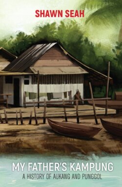
An artist’s impression of historical Aukang circa 1950s.
Incidentally, milestones during my father’s time—literally large stones placed at intervals from each other—were used to mark or indicate important places by how far they were relative to the General Post Office (GPO) at Fullerton Building. This is where Fullerton Hotel is located today.3 For example, the fifth milestone was nearer to the GPO compared to the sixth milestone. Eventually, as rural villages disappeared and Singapore developed a more comprehensive address system, milestones gradually disappeared from everyday use.
My father continued, “However, things get more complicated. In the 1950s and 1960s, the political constituency was even called Punggol, instead of Hougang. In the 1955 State Assembly elections, the electoral division called Punggol-Tampines also covered Aukang, then part of Punggol.”
Incidentally, Teochew Goh Chew Chua, one of the three successful PAP candidates in the 1955 State Assembly elections—the other two being Lee Kuan Yew and Lim Chin Siong—lived in Aukang.4 In 1955, Goh contested in the Punggol-Tampines division, which included Aukang. While more than 29,000 lived in Punggol-Tampines, only about 6,600 were electors, of which 4,500 were Chinese. Goh was later re-elected in Tampines constituency in 1959 and appointed Parliamentary Secretary to the Deputy Prime Minister. He passed away in 1971.
My father continued, “In other words, what was named Punggol constituency really referred to what are Hougang and Punggol today, so in the same speech, in one moment, the Member of Parliament could be referring to one part of Punggol—that is to say, the Hougang part—and in the very next moment, referring to Punggol proper. So, in a certain peculiar sense, even ‘Punggol’ sometimes really means ‘Aukang’.
“In fact, in the Legislative Assembly General Election of 1959, a distant relative of ours, Tay Keng Hock, or Hock Ku (Uncle Hock in Teochew), stood as an independent candidate for the constituency of Punggol. We used to live on his huge estate at Jalan Payoh Lai. Of the four candidates, Hock Ku brought up the rear, with less than six percent of the voters finding the coconut tree—the symbol he had chosen for his election posters—appealing.”
I looked it up; it’s true:
| Candidates | Party | Total Votes |
| Ng Teng Kian | PAP | 4,072(46.39%) |
| Tan Jin Hong | SPA | 3,655(41.64%) |
| Quah Heck Peck | LSP | 554(6.31%) |
| Tay Keng Hock | - | 497(5.66%) |
Source: 1959 Legislative Assembly General Election results from the Elections Department.
These revelations prompted me to find out more. To me, the history of a place, and to a certain extent even its geography, is messy with many twists and turns. So, while the terms “Hougang” and “Aukang” did not refer to the exact same boundaries and “Punggol” sometimes meant “Aukang”, it was exciting to learn more about my father’s kampung.
Later, while looking for sources on geographical boundaries I could concentrate on, I found out that Aukang had even been referred to as… a “Teochew Kingdom”.