Читать книгу The Book of the National Parks - Robert Sterling Yard - Страница 27
На сайте Литреса книга снята с продажи.
VII
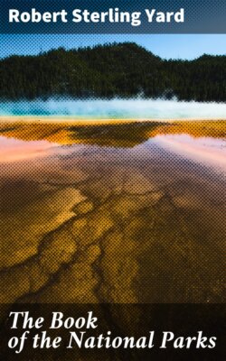
ОглавлениеThe Yosemite's geological history is much more thrilling. Everyone who sees it asks, How did Nature make the Yosemite Valley? Was it split by earth convulsions or scooped by glacier? Few ask what part was played by the gentle Merced.
The question of Yosemite's making has busied geologists from Professor Whitney of the University of California, who first studied the problem, down to F.E. Matthes, of the United States Geological Survey, whose recent exhaustive studies have furnished the final solution. Professor Whitney maintained that glaciers never had entered the valley; he did not even consider water erosion. At one time he held that the valley was simply a cleft or rent in the earth's crust. At another time he imagined it formed by the sudden dropping back of a large block in the course of the convulsions that resulted in the uplift of the Sierra Nevada. Galen Clark, following him, carried on his idea of an origin by force. Instead of the walls being cleft apart, however, he imagined the explosion of close-set domes of molten rock the riving power, but conceived that ice and water erosion finished the job. With Clarence King the theory of glacial origin began its long career. John Muir carried this theory to its extreme.
Since the period of Muir's speculations, the tremendous facts concerning the part played by erosion in the modification of the earth's surface strata have been developed. Beginning with W.H. Turner, a group of Yosemite students under the modern influence worked upon the theory of the stream-cut valley modified by glaciers. The United States Geological Survey then entered the field, and Matthes's minute investigations followed; the manuscript of his monograph has helped me reconstruct the dramatic past.
The fact is that the Yosemite Valley was cut from the solid granite nearly to its present depth by the Merced River; before the glaciers arrived, the river-cut valley was twenty-four hundred feet deep opposite El Capitan, and three thousand feet deep opposite Eagle Peak. The valley was then V-shaped, and the present waterfalls were cascades; those which are now the Yosemite Falls were eighteen hundred feet deep, and those of Sentinel Creek were two thousand feet deep. All this in pre-glacial times.
Later on the glaciers of several successive epochs greatly widened the valley, and measurably deepened it, making it U-shaped. The cascades then became waterfalls.
But none will see the Yosemite Valley and its cavernous tributary canyons without sympathizing a little with the early geologists. It is difficult to imagine a gash so tremendous cut into solid granite by anything short of force. One can think of it gouged by massive glaciers, but to imagine it cut by water is at first inconceivable.
To comprehend it we must first consider two geological facts. The first is that no dawdling modern Merced cut this chasm, but a torrent considerably bigger; and that this roaring river swept at tremendous speed down a sharply tilted bed, which it gouged deeper and deeper by friction of the enormous masses of sand and granite fragments which it carried down from the High Sierra. The second geological fact is that the Merced and Tenaya torrents sand-papered the deepening beds of these canyons day and night for several million years; which, when we remember the mile-deep canyons which the Colorado River and its confluents cut through a thousand or more miles of Utah and Arizona, is not beyond human credence, if not conception.
But, objects the sceptical, the Merced couldn't keep always tilted; in time it would cut down to a level and slow up; then the sand and gravel it was carrying would settle, and the stream stop its digging. Again, if the stream-cut valley theory is correct, why isn't every Sierra canyon a Yosemite?
Let us look for the answer in the Sierra's history.
The present Sierra Nevada is not the first mountain chain upon its site. The granite which underlay the folds of the first Sierra are still disclosed in the walls of the Yosemite Valley. The granites which underlay the second and modern Sierra are seen in the towering heights of the crest.
Once these mountains overran a large part of our present far west. They formed a level and very broad and high plateau; or, more accurately, they tended to form such a plateau, but never quite succeeded, because its central section kept caving and sinking in some of its parts as fast as it lifted in others. Finally, in the course, perhaps, of some millions of years, the entire central section settled several thousand feet lower than its eastern and western edges; these edges it left standing steep and high. This sunken part is the Great Basin of to-day. The remaining eastern edge is the Wasatch Mountains; the remaining western edge is the Sierra. That is why the Sierra's eastern front rises so precipitously from the deserts of the Great Basin, while its western side slopes gradually toward the Pacific.
But other crust changes accompanied the sinking of the Great Basin. The principal one was the rise, in a series of upward movements, of the remaining crest of the Sierra. These movements may have corresponded with the sinkings of the Great Basin; both were due to tremendous internal readjustments. And of course, whenever the Sierra crest lifted, it tilted more sharply the whole granite block of which it was the eastern edge. These successive tiltings are what kept the Merced and Tenaya channels always so steeply inclined that, for millions of years, the streams remained torrents swift enough to keep on sandpapering their beds.
The first of these tiltings occurred in that far age which geologists call the Cretaceous. It was inconsiderable, but enough to hasten the speed of the streams and establish general outlines for all time. About the middle of the Tertiary Period volcanic eruptions changed all things. Nearly all the valleys except the Yosemite became filled with lava. Even the crest of the range was buried a thousand feet in one place. This was followed by a rise of the Sierra Crest a couple of thousand feet, and of course a much sharper tilting of the western slopes. The Merced and Tenaya Rivers must have rushed very fast indeed during the many thousand years that followed.
The most conservative estimate of the duration of the Tertiary Period is four or five million years, and until its close volcanic eruptions continued to fill valleys with lava, and the Great Basin kept settling, and the crest of the Sierra went on rising; and with each lifting of the crest, the tilt of the rivers sharpened and the speed of the torrents hastened. The canyon deepened during this time from seven hundred to a thousand feet. The Yosemite was then a mountain valley whose sloping sides were crossed by cascades.
Then, about the beginning of the Quaternary Period, came the biggest convulsion of all. The crest of the Sierra was hoisted, according to Matthes's calculations, as much as eight thousand feet higher in this one series of movements, and the whole Sierra block was again tilted, this time, of course, enormously.
For thousands of centuries following, the torrents from Lyell's and McClure's melting snows must have descended at a speed which tore boulders from their anchorages, ground rocks into sand, and savagely scraped and scooped the river beds. Armed with sharp hard-cutting tools ripped from the granite cirques of Sierra's crest, these mad rivers must have scratched and hewn deep and fast. And because certain valleys, including the Yosemite, were never filled with lava like the rest, these grew ever deeper with the centuries.
The great crust movement of the Quaternary Period was not the last, by any means, though it was the last of great size. There were many small ones later. Several even have occurred within historic times. On March 26, 1872, a sudden earth movement left an escarpment twenty-five feet high at the foot of the range in Owens Valley. The village of Lone Pine was levelled by the accompanying earthquake. John Muir, who was in the Yosemite Valley at the time, describes in eloquent phrase the accompanying earthquake which was felt there. A small movement, doubtless of similar origin, started the San Francisco fire in 1906.
Conditions created by the great Quaternary tilting deepened the valley from eighteen hundred feet at its lower end to twenty-four hundred feet at its upper end. It established what must have been an unusually interesting and impressive landscape, which suggested the modern aspect, but required completion by the glaciers.
Geologically speaking, the glaciers were recent. There were several ice invasions, produced probably by the same changes in climate which occasioned the advances of the continental ice sheet east of the Rockies. Matthes describes them as similar to the northern glaciers of the Canadian Rockies of to-day. For unknown thousands of years the Valley was filled by a glacier three or four thousand feet thick, and the surrounding country was covered with tributary ice-fields. Only Cloud's Rest, Half Dome, Sentinel Dome, and the crown of El Capitan emerged above this ice. The glacier greatly widened and considerably deepened the valley, turned its slopes into perpendiculars, and changed its side cascades into waterfalls. When it receded it left Yosemite Valley almost completed.
There followed a long period of conditions not unlike those of to-day. Frosts chipped and scaled the granite surfaces, and rains carried away the fragments. The valley bloomed with forests and wild flowers. Then came other glaciers and other intervening periods. The last glacier advanced only to the head of Bridal Veil Meadow. When it melted it left a lake which filled the Valley from wall to wall, three hundred feet deep. Finally the lake filled up with soil, brought down by the streams, and made the floor of the present valley.
The centuries since have been a period of decoration and enrichment. Frost and rain have done their perfect work. The incomparable valley is complete.