Читать книгу The Book of the National Parks - Robert Sterling Yard - Страница 31
На сайте Литреса книга снята с продажи.
II
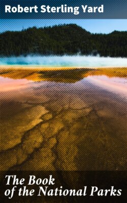
ОглавлениеThe region is roughly pear-shaped. A straight line drawn from Pine Creek Pass at its northern end to Sheep Mountain on the southern base line measures sixty-eight miles; the park is thirty-six miles wide at its widest, just north of Mount Whitney. Its eastern boundary, the crest of the Sierra, divides many notable peaks. From north to south we pass, as we travel the John Muir Trail, Mount Humphreys, 13,972 feet; Mount Darwin, 13,841 feet; Mount Winchell, 13,749 feet; Split Mountain, 14,051 feet; Striped Mountain, 13,160 feet; Mount Baxter, 13,118 feet; Junction Peak, 13,903 feet; Mount Tyndall, 14,025 feet; and Mount Whitney, 14,501 feet; supporting Whitney on the south is Mount Langley, 14,042 feet; all these connected by splintered peaks, granite ledges, and mountain masses scarcely less in altitude.
Between the bristling crest of this snow-daubed eastern boundary and the park's western boundary, thousands of feet lower where the forests begin, the region roughly divides into parallel zones. That which immediately adjoins the crest upon its west side, a strip ten miles or more in width, is known to its devotees as the High Sierra. It is a country of tremendous jagged peaks, of intermediate pinnacled walls, of enormous cirques holding remnants of once mighty glaciers, of great fields of sun-cupped snow, of turquoise lakes resting in chains upon enormous granite steps; the whole gleaming like chased silver in the noon sun; a magical land of a thousand Matterhorns, whose trails lead from temple to temple, so mighty of size and noble of design that no mind less than the Creator's could ever have conceived them.
The High Sierra has been celebrated for many years in the fast-growing brotherhood of American mountain climbers, east as well as west, many of whom proclaim its marked superiority to all parts of the Swiss Alps except the amazing neighborhood of Mont Blanc. With the multiplication of trails and the building of shelters for the comfort of the inexperienced, the veriest amateur of city business life will find in these mountains of perpetual sunshine a satisfaction which is only for the seasoned mountaineer abroad.
The zone adjoining the High Sierra upon its west is one of far wider range of pleasure. Subsiding rapidly in elevation, it becomes a knobbed and bouldered land which includes timber-line and the thin forests of wind-twisted pines which contend with the granite for foothold. It is crossed westward by many lesser ranges buttressing the High Sierra; from these cross ranges many loftier peaks arise, and between them roar the rivers whose thousands of contributing streams drain the snow-fields and the glaciers of the white heights.
Finally, paralleling the western boundary, is the narrow zone in which this region meets and merges with the greater forests and the meadows beyond the boundary. Here, in the southwestern corner, is the marvellous warm forest in which trees of many kinds attain their maximum of size and proportion, and which encloses a million sequoia trees, including the greatest and oldest embodiments of the principle of life. This extraordinary forest was reserved in 1890 under the title of the Sequoia National Park. At the same time was created the General Grant National Park, a reservation of four square miles of similar forest, virtually a part of it, but separated because of an intervening area of privately owned lands.
Thus does this region run the gamut of supremacy from the High Sierra upon its east, to the Giant Forest upon its west.
Of no less distinction are its waters. Innumerable lakelets of the High Sierra, born of the snows, overflow in tiny streams which combine into roaring, frothing creeks. These in turn, augmented by the drainage of the lofty tumbled divides, combine into powerful little rivers. Four river systems originate in this region.
Far in the north a lake, more than eleven thousand feet high, lying at the western foot of Mount Goddard, begins the South Fork of the San Joaquin River, which drains the park's northern area. Incidentally, it has cut a canyon of romantic beauty, up which the John Muir Trail finds its way into the park.
The northern middle area of the park is drained by the Middle and South Forks of the Kings River, which find their origins in perhaps forty miles of Sierra's crest. The drainage basins of these splendid streams cover nearly half of the park's total area, and include some of the biggest, as well as some of the wildest and most beautiful mountain scenery in the world. Bounded upon their west by an arc of snowy mountains, separated by the gigantic Monarch Divide, flanked by twisted ranges and towering peaks, they cascade westward through meadows of rank grasses and vividly colored wild-flowers, alternating with steep-sided gorges and canyons of sublimity. Dropping thousands of feet within a few miles, they abound in cascades and majestic falls, between which swift rapids alternate with reaches of stiller, but never still, waters which are the homes of cut-throat trout. Each of these rivers has its canyon of distinguished magnificence. The Tehipite Valley of the Middle Fork and the Kings River Canyon of the South Fork are destined to world celebrity.
The southwestern area of the park is drained by five forks of the beautiful Kaweah River. These streams originate on the north in the divide of the South Fork of the Kings River, and on the east in a conspicuously fine range known as the Great Western Divide. They wind through the wooded valleys of the Sequoia National Park. Upon their banks grow the monsters of the American forest.
The southern area is drained by the Kern River, into which flow the waters of Mount Whitney and his giant neighbors. The Kern Canyon is one of Roosevelt's noblest expressions. Flowing southward between precipitous walls three thousand feet and more in height, flanked upon the east by monsters of the High Sierra, and on the west by the splendid elevations of the Great Western Divide, it is a valley supremely fitted for the highest realization of the region's gifts of enjoyment. From camps beside its trout-haunted waters, it is a matter of no difficulty for those equipped for the trail to reach the summit of Whitney, on the one hand, and the Giant Forest on the other.
Near the southern boundary of the park, Golden Trout Creek enters the Kern. It originates at the very crest of the Sierra, which it follows closely for many miles before swinging westward to its outlet. In this stream is found a trout which appears, when fresh caught, as though carved from gold. Popularly it is known as the golden trout; its scientific name is Salmo Rooseveltii. Originally, no doubt, the color evolved from the peculiar golden hues of the rocks through which its waters flow. The golden trout has been transplanted into other Sierra streams, in some of which, notably the open upper waters of the Middle Fork of the Kings, it has thrived and maintained its vivid hue. In sheltered waters it has apparently disappeared, a fact which may merely mean that its color has changed with environment.