Читать книгу Yoho National Park: The Mountains, the Rocks, the Scenery - David M. Baird - Страница 5
На сайте Литреса книга снята с продажи.
BOUNDARIES OF THE PARK
ОглавлениеTable of Contents
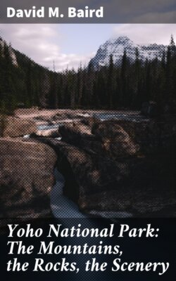
Yoho National Park is essentially the drainage basin of the upper Kicking Horse River and its tributaries. The park lies wholly within the Province of British Columbia. Kootenay National Park, also in British Columbia, adjoins it on the south; and Banff National Park, in Alberta, adjoins it on the east. Hamber Park—a British Columbia provincial park—forms part of its western boundary.
Most of the boundaries of Yoho National Park are divides. Its eastern boundary, as we have seen above, is the great continental divide. From the northernmost point in the park—on the peak of Mount Rhondda at an elevation of 10,025 feet—a straight-line artificial boundary extends southwest to Ayeshal Peak. The western boundary of the park now follows the divide that separates the drainage system of the uppermost Kicking Horse River and its tributaries from rivers flowing into Columbia River or into Kicking Horse River below the park boundary. At the West Gate the boundary is part of a short, straight, surveyed line from the dividing ridge south to Kicking Horse River. Southwest from this point the boundary follows the main Kicking Horse River to the big bend below Wapta Falls; then it turns east to Beaverfoot River and follows this river southerly and easterly into the valley of Ice River. Another short surveyed line from Ice River to the peak of nearby Mount Mollison brings the boundary once again to a divide. It follows this divide northerly to the vicinity of Mount Sharp, from where it sweeps in a surveyed, curving line back to the continental divide. Thus Yoho National Park includes almost all of the drainage area of Kicking Horse River above Wapta Falls.