Читать книгу The Handy Geography Answer Book - Paul A Tucci - Страница 10
На сайте Литреса книга снята с продажи.
ОглавлениеDEFINING THE WORLD
DEFINITIONS AND HISTORY
What is the origin of the word “geography”?
The word “geography” is from the Greek word geographia and can be divided into two parts, geo, meaning the Earth, and graphy, which refers to writing. So geography can be loosely translated as “writing about the Earth.” Ancient geography was often filled with descriptions of remote places, but modern geography has become much more than writing about the Earth. Contemporary geographers have a difficult time defining the discipline. Some popular definitions include “the bridge between the human and the natural sciences,” “the mother of all sciences,” and “anything that can be mapped.”
Who invented geography?
The Greek philosopher Thales was one of the first to argue about the shape of the world in the sixth century B.C.E. And Chinese texts of the fifth century B.C.E. describe the provinces of China in great detail. However, the Greek scholar Eratosthenes is credited with the first use of the word “geography” in the third century B.C.E. He is also known as the “father of geography” for his geographical writing and accomplishments, including the measurement of the circumference of the Earth, the tilt of the Earth’s axis, the distance from the Earth to the sun, and the concept of “Leap Day.”
What is geologic time?
Geologic time is a time scale that divides the history of the planet Earth into eras, periods, and epochs from the birth of the planet to the present. The oldest era is the Precambrian Era, which began 4.6 billion years ago and ended about 570 million years ago. Next came the Paleozoic Era, which lasted from 570 to 245 million years ago, followed by the Mesozoic Era, from 245 to 66 million years ago. We’re now living in the Cenozoic Era, which began 66 million years ago. The Paleozoic, Mesozoic, and Cenozoic eras are each divided into periods. Additionally, the Cenozoic Era is divided into even smaller units of time called epochs. The present epoch that we live in today, which spans the last ten thousand years (the time since the last significant Ice Age), is called the Holocene Epoch.
When did geography begin?
We must assume that humans have always wanted to know where sources of food are located, places to live, and the location of one’s protective group. Geographic thought has been present for thousands of years. Maps drawn in the sand, etched in stone, or painted on the walls of caves, as well as explorations to distant lands, were made by the earliest civilizations. Geographic knowledge has been accumulating since the beginning of humankind.
What new epoch has recently been proposed by Nobel Prize winner Paul Crutzen?
Most epochs last approximately more than 3 million years, enough time to deposit traces of subtle changes in the conditions on the planet, for scientists to discover in future years. Dutch atmospheric chemist and Nobel Prize winner Paul Crutzen coined the term “Anthropocene,” or “New Man,” epoch because changes to our planet, brought on by human activities like habitat destruction, environmental degradation, and the extinction of thousands of plant and animal species since the beginning of the Industrial Revolution two hundred years ago, will leave an indelible mark in the boundary layer of the surface of our planet. But some scientists disagree and assert that it really is not a new epoch, just a warm period during our current Holocene Epoch, or Ice Age, which should continue for another million years.
What is the AAG?
The Association of American Geographers (AAG) is a professional organization of academic geographers and geography students. The AAG was founded in 1904 and publishes two key academic journals in geography, the Annals of the Association of American Geographers and the Professional Geographer, as well as the AAG Review of Books and the online AAG Newsletter. The AAG also holds annual conferences and supports regional and specialty groups of geographers. Its membership spans more than sixty countries.
What is the NCGE?
The National Council for Geographic Education (NCGE) is an organization of educators that seeks to promote geographic education. The NCGE was founded by educator George Miller and was chartered in 1915 with a stated mission to enhance the status and quality of geography teaching from kindergarten through university. The NCGE publishes the Journal of Geography and holds conferences every year.
What is the National Geographic Society?
Founded in 1888, the National Geographic Society is one of the largest scientific and educational institutions in the world. It has supported exploration, cartography, and discovery, and it publishes the popular magazine National Geographic, in English and many other languages, and is the fifth-most-popular magazine in the United States. The society’s publishing operations reach a global audience of over 600 million people each month.
What do modern geographers do?
While there are a few jobs with the title of “geographer,” many geography students use their analytical ability and knowledge of the world to work in a variety of fields. Geography students often take jobs in fields such as city planning, cartography, marketing, real estate, environment, and teaching.
The geologic time scale
THE EARTH
How old is the Earth?
The Earth is approximately 4.54 billion years old (+/- 1%). We know this because scientists use radiometric dating techniques to analyze samples in order to determine its age. One of the oldest materials found in the Earth is a sample of crystals of the mineral zircon, found in Western Australia, that is at least 4.04 billion years old.
How was the Earth formed?
Scientists believe that the Earth was formed, along with the rest of the solar system, from a massive gas cloud. As the cloud solidified, it formed the solid masses such as the Earth and the other planets.
What is the circumference of the Earth?
The circumference of the Earth at the equator is 24,901.55 miles (40,066.59 km). Due to the irregular, ellipsoid shape of the Earth, a line of longitude wrapped around the Earth going through the north and south poles is 24,859.82 miles (40,000 km). Therefore, the Earth is a little bit (about 41 miles [66 km]) wider than it is high. The diameter of the Earth is 7,926.41 miles (12,753.59 km).
Is the Earth a perfect sphere?
No, the Earth is a bit wider than it is “high.” The shape is often called a geoid (Earth-like) or an ellipsoid. The rotation of the Earth causes a slight bulge toward the equator. The circumference of the Earth at the equator is 24,901.55 miles (40,066.59 km), which is about 41 miles (66 km) greater than the circumference through the poles (24,859.82 miles [40,000 km]). If you were standing on the moon, looking back home, it would be virtually impossible to see the bulge, and the Earth would appear to be a perfect sphere (which it practically is).
What is a hemisphere?
A hemisphere is half of the Earth. The Earth can actually be divided into hemispheres in two ways: by the equator and by the Prime Meridian (through Greenwich, England) at 0 degrees longitude and another meridian at 180 degrees longitude (near the location of the International Date Line in the western Pacific Ocean. Zero and 180 degrees longitude divide the Earth into the Eastern (most of Europe, Africa, Australia, and Asia) and Western (the Americas) Hemispheres.
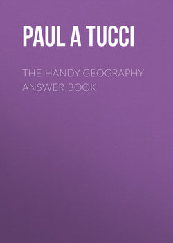
What is the equator?
The equator divides the Earth into Northern and Southern Hemispheres. There are seasonal differences between the Northern and Southern Hemispheres. When it is winter in the Northern Hemisphere, it is summer in the Southern Hemisphere. But there is no such difference between the Eastern and Western Hemispheres.
Western (left) and Eastern Hemispheres of our planet
How was the circumference of the Earth determined?
The Greek geographer and librarian at the Great Library of Alexandria, Eratosthenes (c. 273—c. 192 B.C.E.), was aware that the sun reached the bottom of a well in Egypt only once a year, on the first day of summer. The well that he studied was near the city of Aswan and the Tropic of Cancer (where the sun is directly overhead at noon on the summer solstice). Around the year 240 B.C.E., Eratosthenes estimated the distance between the well and the city of Alexandria based on the length of time it took camel caravans to travel between the two places. He measured the angle of the sun’s shadow in Alexandria at the same time that the well was lit by the sun and then used a mathematic formula to determine that the circumference of the Earth was 25,000 miles (about 40,000 km)—amazingly close to the actual figure, which at the equator is 24,898 miles (40,070 km).
What are the Arctic and Antarctic Circles?
The circles are imaginary lines that surround the North and South Poles at 66.5 degrees latitude. The Arctic Circle is a line of latitude at 66.5 degrees north of the equator, and the Antarctic Circle is a line of latitude at 66.5 degrees south. Areas north of the Arctic Circle are dark for 24 hours near December 21 and areas south of the Antarctic Circle are dark for 24 hours near June 21. Almost all of the continent of Antarctica is located to the south of the Antarctic Circle.
If the Earth is so large, why did Christopher Columbus think that India was close enough to reach by sailing west from Europe?
The Greek geographer Posidonius did not believe Eratosthenes’s earlier calculation, so he performed his own measurement of the Earth’s circumference and arrived at the figure of 18,000 miles (28,962 km). Columbus used the circumference estimated by Posidonius when he argued his plan before the Spanish court. The 7,000-mile (11,263-km) difference between the actual circumference and the one Columbus used led him to believe he could reach India rather quickly by sailing west from Europe.
How fast does the Earth spin?
It depends on where you are on the planet. If you were standing on the North Pole or close to it, you would be moving at a very slow rate of speed—nearly zero miles per hour. On the other hand, those who live at the equator (and therefore have to move about 24,900 miles [40,000 km] in a 24-hour period) zoom at about 1,038 miles (1,670 km) per hour. Those in the mid-latitudes, as in the United States, breeze along from about 700 to 900 miles (1,126 to 1,448 km) per hour.
Why don’t we feel the Earth moving?
Even though we constantly move at a high rate of speed, we don’t feel it, just as we don’t feel the speed at which we’re flying in an airplane or driving in a car. It’s only when there is a sudden change in speed that we notice, and if the Earth made such a change we would certainly feel it.
Does the Earth spin at a constant rate?
The rotation of the Earth actually has slight variations. Motion and activity within the Earth, such as friction due to tides, wind, and other forces, change the speed of the planet’s rotation a little. These changes only amount to milliseconds over hundreds of years but do cause people who keep exact time to make corrections every few years.
What is the axis of the Earth?
The axis is the imaginary line that passes through the North and South Poles about which the Earth revolves. Because the Earth is tilted along this spin axis, as we make our way around the sun in an elliptical orbit for 365 days, we have our seasons (winter, spring, summer, and fall). As the Earth’s axis is pointed toward the sun for people in the Northern Hemisphere, we experience summer. At the same time, for people in the Southern Hemisphere, as the axis points away from the sun, we experience winter.
What is inside the Earth?
The Earth is comprised of several layers: crust, mantle, and core. The outermost part of the Earth, the crust, is divided into huge plates that float atop the mantle, and are always in motion. The crust is comprised of the elements iron, oxygen, silicon, magnesium, sulphur, nickel, and trace amounts of many other elements. Beneath the crust is the mantle, which is about 1,800 miles (2,890 km) deep and is composed of silicate rocks, which are heated and cooled by the core. The mantle, which makes up the bulk of the interior of the Earth, is composed of three layers—two outer layers are solid and the inner layer (the asthenosphere) is a layer of rock that is easily moved and shaped. At the very center of the Earth is a dense and solid inner core of iron and other minerals that is about 1,520 miles (1,220 km) wide. Surrounding the inner core is a liquid (molten) outer core that is about 1,355 miles (2,180 km) thick.
If I dug through the Earth, would I end up in China?
If you are in North America and you were able to dig through the Earth (which is impossible due to such things as pressure, the molten outer core, and solid inner core), you would end up in the Indian Ocean, far from landmasses. If you were really lucky, you might end up on a tiny island, but you’re surely not going to end up in China. The points at opposite sides of the Earth are called antipodes. Most antipodes of Europe fall into the Pacific Ocean.
When do earthquakes occur?
Earthquakes occur when the plates that comprise the Earth’s crust rub against each other. We have mountains created when these gigantic plates collide and large trenches created when one plate slides underneath another.
What is the Mid-Atlantic Ridge?
We don’t get to appreciate the beauty of this huge mountain range because it’s located at the bottom of the Atlantic Ocean (with one exception: Iceland is a part of the ridge). It is part of one of the longest mountain ranges in the world. The ridge is a crack between tectonic plates where new ocean floor is being created as magma flows up from under the Earth. As more crust is created, it pushes the older crust farther away. The new crust at the ridge piles up to form mountains and then begins to move across the bottom of the ocean. Because the Earth can’t get larger as more crust is created, the crust eventually has nowhere to go except back into the Earth. This is where subduction occurs.
What is subduction?
When two tectonic plates meet and collide, crust must either be lifted up, as in the case of the Himalayas, or it must be sent back into the Earth. When crust from one plate slides under the crust of another, it is called subduction, and the area around the subduction is called a subduction zone.
In Iceland’s National Park of Thingvellir one can visit the rift valley that is part of the Mid-Atlantic Ridge.
What is the North Magnetic Pole?
The North Magnetic Pole is where compass needles around the world point. Today it is located beyond Canada’s Northwest Territories near 85.9 degrees north, 147 degrees west (latitude and longitude), about 900 miles (1,450 km) away from absolute North Pole. Since it moves continuously at about 34 miles per hour (55 km per hour), global research scientists are constantly trying to determine the current location of the pole. In order to determine true north, look at a recent topographic map for your local area. It should note the “magnetic declination,” which means the degrees east or west that you’ll need to rotate your compass to determine which way is actually north.
Who had the first idea that there was a magnetic North Pole?
As early as the year 1600, English physician and naturalist William Gilbert was the first person to define the North Magnetic Pole as the point on the Earth where the Earth’s magnetic fields point vertically downward. It was not until 1831 that James Clark Ross found this point. Another famous explorer, Roald Amundsen, found the North Magnetic Pole in 1903, but in a different location. In a third major exploration in 1947, Paul Serson and Jack Clark found the pole on Prince of Wales Island.
CONTINENTS AND ISLANDS
What are continents?
Continents are the six or seven large landmasses on the planet. If you count seven continents, these include Europe, Asia, Africa, Australia, Antarctica, North America, and South America. Some geographers refer to six continents by combining Europe and Asia as Eurasia, due to the fact that it is one large tectonic plate and landmass. So whether you count Europe and Asia as one continent or two (divided at the Ural Mountains in western Russia) is up to the individual. Australia is the only continent that is its own country.
Why is the number of continents controversial?
We find that there is controversy about how many continents there truly are because of how experts classify and define the word “continent.” It is generally accepted that a continent is a very large, continuous, and discrete landmass, likely separated by water. By using this definition, places like Greenland should be classified as a continent (since, like Australia, it is a landmass surrounded by water), but it is not. North and South America are typically classified as two continents, even though they are joined. Often, experts classify Europe and Asia as two continents, even though they are joined together, with no water between them. Depending on where you live on this planet, you may conclude that there are 6 or 7 continents. In most of the English- and Chinese-speaking world, there are seven continents (Asia, Africa, Europe, North America, South America, Australia, and Antarctica), while in Russia, Eastern Europe, and Japan, experts there consider Europe and Asia as one continent called Eurasia. And, in other parts of the world, experts consider North and South America as one landmass. So according to these two latter views of geography, we only have 6 continents, and not seven.
The crust of our planet is a network of several tectonic (or lithospheric) plates, ranging from just a few hundred miles across to thousands of miles, such as the Pacific and Antarctic plates.
What is the largest continent?
If you were to combine the two landmasses of Europe and Asia into one, the largest continent is Eurasia at 21,100,000 square miles (54,649,000 square km). But even if you consider Europe and Asia to be two separate continents, Asia is still the largest, at 17,300,000 square miles (44,807,000 square km).
What is a subcontinent?
A subcontinent is a landmass that has its own continental shelf and its own continental plate. Currently, India and its neighbors form the only subcontinent, but in millions of years, Eastern Africa will break off from Africa and become its own subcontinent.
What was Pangea?
About 250 million years ago, during what is called the Paleozoic Period, all of the land on Earth was lumped together into one large continent known as Pangea. Faults and rifts broke the landmasses apart and pushed them away from each other. The continents slowly moved across the Earth to their present positions, and they continue to move today. The Indian subcontinent (composed of India and its neighbors) continues to push into Asia and create the Himalayas. German scientist Alfred Wegener, who described his theory on continental drift, coined the term “Pangea” in 1912. More than ten years later, the word “Pangea” made its way into English scientific literature in 1926.
A rough drawing illustrating how continental drift caused the continents of Africa and South America to drift apart over millions of years.
Where was Pangea located?
It was located near present-day Antarctica and has slowly drifted and split to form the continents as we know them today. The continents and their tectonic plates continue to move and will one day be in a much different arrangement than they are today.
How are mountains formed?
The process of orogeny, or mountain building, is related to continental drift. When two tectonic plates collide, they often form mountains. This is because the Earth’s crust shortens and thickens, and the thicker crust gradually rises. Layers of rock far beneath the new mountain are superheated and become lighter, causing the rocks to gradually rise. The Himalayas are the result of the Indo-Australian Plate colliding with the Eurasian Plate. At these collision zones, volcanoes and earthquakes are common.
How did the Himalayas form?
About 30 to 50 million years ago, the landmass of India pressed into the landmass of Asia, pushing up land at the place of impact and creating the Himalayas. Even today, as the Indian subcontinent presses against Asia, the Himalayas continue to grow and change.
How much do the Himalayan Mountains grow?
Scientists estimate that the Himalayan Mountains grow .39 inches (1 cm) per year. In 1 million years, they will be approximately 6.2 miles (10 km) higher.
What is the highest point in the world?
At 29,029 feet (8,848 meters), the highest point above sea level in the world is Mt. Everest, which lies on the border of China and Nepal. This figure is based upon surveys of the height that were done in 1999 and 2005, without including the ice/snow cap to the figure. In one recent Chinese survey, the snow cap measured an additional 11 feet (3.35 meters).
Is Mt. Everest growing taller?
Because of the shifting plates underneath the surface of the Earth, Mt. Everest is actually changing its size by moving upward at an approximate rate of .16 inches (4.06 mm) and northeastward at a rate of .12–.24 inches (3.05–6.1 mm) per year.
What are the highest points on each continent?
In Asia, the highest peak is Mt. Everest at 29,029 feet (8,848 meters). The highest peak in South America, Aconcagua, lies in Argentina at 22,838 feet (6,961 meters). In North America, Alaska’s Denali (also called Mt. McKinley from 1917 to 2015) is 20,322 feet (6,194 meters). Mt. Kilimanjaro at 19,341 feet (5,895 meters) is in Africa’s Tanzania. Ice-covered Antarctica’s high point is known as Vinson Massif, or Mt. Vinson, at 16,050 feet (4,892 meters). Europe’s Mont Blanc is in the Alps between France and Italy at 15,771 feet (4,807 meters). A debate continues on whether or not to include in this list Mt. Elbrus, in the Caucasus Mountains, straddling the geographic border between what is Europe and Asia. At 18,510 feet (5642 meters), it is also considered by many to be the highest mountain in Europe. Australia’s high point, Mt. Kosciuszko, is the lowest high point of all the continents at 7,310 feet (2,228 meters).
What else is interesting about Mt. Elbrus?
The mountain is actually a dormant volcanic cone and has two peaks, with the west peak approximately 69 feet (21 meters) higher than the east peak. Although the lower peak was first ascended in 1829, it was not until 1874 that the higher peak was scaled.
What is the highest mountain on Earth?
The highest mountain lies on the Big Island of Hawaii, with a height from the bottom of the sea floor, where it begins, rising 33,480 feet (10,205 meters) to the top of Mauna Kea, which is a volcano that rises 13,680 feet (4,170 meters) above sea level. The summit of Mt. Everest is actually considered to be the highest elevation above sea level.
What were the seven wonders of the ancient world?
While there was often disagreement by ancient and classical scholars as to which major works of art and architecture could be considered wonders, these seven were nearly always on the list: the Pyramids of Egypt (the only remaining wonder), the Colossus of Rhodes (on the island of Rhodes in Greece), the Temple of Artemis at Ephesus (a marble temple in Turkey), the Mausoleum of Halicarnassus (Bodrum, Turkey), the Statue of Zeus at Olympia (an ivory and gold statue in southwestern Greece), the Hanging Gardens of Babylon (an enormous garden building, with plants of every kind, near Al Hillah, Iraq), and the Lighthouse of Alexandria (on the island of Pharos, near Alexandria, Egypt).
A comparison of Mt. Everest, Mt. McKinley, Mt. Sharp (on Mars), and Mt. Rainier.
What are the seven wonders of the modern world?
According to the American Society of Civil Engineers, the seven wonders of the modern world include the Channel Tunnel between England and France; the CN Tower in Toronto, Ontario, Canada; the Empire State Building in New York City; the Golden Gate Bridge in San Francisco, California; the Itaipu Dam between Brazil and Paraguay; the Netherlands North Sea Protection Works; and the Panama Canal.
What are the seven natural wonders of the world?
These include the Aurora Borealis (northern lights), Mt. Everest (on the border of China and Nepal), Victoria Falls (near the border of Zambia and Zimbabwe in eastern Africa), the Grand Canyon (in Arizona in the United States), the Great Barrier Reef (in Australia), Parícutin (volcano in Mexico), and the harbor of Rio de Janeiro (in Brazil) with its stunning topography.
When did agricultural activity first begin?
Agricultural activity began about ten to twelve thousand years ago in a time period known as the first agricultural revolution. It was at this time that humans began to domesticate plants and animals for food. Before the agricultural revolution, people relied on hunting wild animals and gathering wild plants for nutrition. This revolution took place almost simultaneously in different areas of human settlement around the world.
HUMAN CIVILIZATION
Where did agriculture begin?
Agriculture simultaneously began in what is known now as the Middle East (Fertile Crescent), the Yangtze River Region of southern China, the Yellow River Region of northern China, Sub-Saharan Africa, South-Central Andes near modern-day Peru, Bolivia, and Chile, Central Mexico, and the eastern United States.
What is the difference between cultivation and domestication?
Cultivation is the deliberate attempt to sow and manage essentially wild plants and seed. Domestication is when people experiment and consciously select the right seeds to grow for various conditions.
When was the second agricultural revolution?
The second agricultural revolution occurred in the seventeenth century. During this time, production and distribution of agricultural products were improved through machinery, vehicles, and tools, which allowed more people to move away from the farm and into the cities. This mass migration from rural areas to urban areas coincided with the beginning of the Industrial Revolution.
What was the Industrial Revolution?
The Industrial Revolution began in the eighteenth century in England with the transformation from an agricultural-based economy to an industrial-based economy. It was a period of increased development in industry and mechanization that improved manufacturing and agricultural processes, thereby allowing more people to move to the cities. It included the development of the steam engine and the railroad.
How much of the world’s population is devoted to agriculture?
In less-developed countries, such as Asia and Africa, a majority of the population is engaged in agricultural activity. In the more-developed countries of Western Europe and North America, less than one tenth of the population relies on agriculture for their livelihood.
What is the Green Revolution??
The Green Revolution began in the 1960s as an effort by international organizations (especially the United Nations) to help increase the agricultural production of less developed nations. Since that time, technology has helped improve crop output, which is reaching all-time highs throughout the world.
How were animals first domesticated?
Dogs were probably some of the first animals to become domesticated. Wild dogs probably came close to human villages scavenging for food and were quickly trained as companions and protectors. Over time, early agriculturalists realized the value of domesticating other animals and proceeded to do so. Many different kinds of animals were domesticated in different areas of the world.
What are the El Castillo Cave Paintings?
The artwork that adorns the walls of this cave located in Cantabria, in the north of Spain, is currently thought to be the oldest works of human artwork found to date. The artwork has been dated to have been created around 39,000 B.C.E. and depicts three handprint stencils using a material called red ochre, created on a wall of the cave.
What are the Caves of Lascaux?
There are many examples demonstrating that humanity has been interested in its surroundings since the beginning of recorded history. In fact, written on the walls of caves in Lascaux, France, are three dots indicating the brightest stars in the sky, which are estimated to have been drawn around 14000 B.C.E. Neolithic wall paintings found in Çatalhöyük, Turkey, show an early city plan from around 7500 B.C.E.
The Caves of Lascaux in France have clearly visible drawings of such things as human hands and animals, as well as star configurations.
PEOPLE AND COUNTRIES
What is the largest country in the world, in terms of land?
Russia is by far the largest at about 6.592 million square miles (17.075 million square km) and occupies about one tenth of the Earth’s habitable land. Russia is followed in size by Canada, China, the United States, Brazil, Australia, India, Argentina, Kazakhstan, and the Sudan.
Which country has the longest coastline?
The coastline of Canada and its associated islands is the longest in the world, about 164,663 miles (265,523 km) long. The United States has the second-longest coastline at about 82,836 miles (133,312 km).
Which countries have the fewest neighbors?
Approximately thirty-seven independent island nations (such as Australia, New Zealand, and Madagascar) have no neighbors. If you include territories, dependencies, and places managed by other countries, this number swells to seventy-five. Many nations, including Brunei, Cyprus, Haiti, the Dominican Republic, Papua New Guinea, Timor-Leste, Ireland, and the United Kingdom, are island nations that share an island.
Which non-island nations have the fewest neighbors?
There are ten non-island countries that share a land border with just one neighbor: Canada (neighboring the United States), Monaco (France), San Marino (Italy), Vatican City (Italy), Qatar (Saudi Arabia), Portugal (Spain), the Gambia (Senegal), Denmark (Germany), Lesotho (South Africa), and South Korea (North Korea).
Which countries are the most remote, in terms of how connected they are to the rest of the world?
According to the World Policy Institute, which publishes the World Policy Journal, several countries in the world are extremely remote in terms of how they are connected to the world. These countries include North Korea, Somalia, Myanmar, Democratic Republic of the Congo, Niger, Timor-Leste, Madagascar, Burundi, Guinea-Bissau, and Papua New Guinea. These countries are very difficult places to visit.
Which country has the most neighbors?
China is bordered by fourteen neighbors: Afghanistan, Bhutan, India, Kazakhstan, Kyrgyzstan, Laos, Mongolia, Myanmar, Nepal, North Korea, Pakistan, Russia, Tajikistan, and Vietnam.
Which countries in the world have the most neighbors?
There are quite a few countries in the world that share borders with other countries, including Austria (8), Brazil (10), China (14), France (8), Germany (9), Hungary (7), India (7), Iran (7), Mali (7), Niger (7), Poland (7), Russia (14), Saudi Arabia (7), Serbia (8), the Sudan (7), Tanzania (8), Turkey (8), Ukraine (8), and Zambia (8).
What percentage of the world’s population can travel without obtaining a visa?
According to experts at the World Tourism Organization, 39% of the world’s population does not need a visa in order to travel to their destination.
How does a city get chosen to host the Olympics?
The International Olympic Committee chooses a city as an Olympic site through a complex process lasting two years. Candidate cities (and their countries) must prepare answers to two rather detailed questionnaires, which describe how well the city is prepared for such criteria as environmental impact, climate, security, medical services, marketing, Olympic Village/housing, and transportation. Cities eagerly spend millions of dollars in construction and preparation for possible selection as a host city as an investment in the city’s future.
What countries in the world do not use the metric system?
The metric system has been used for more than two hundred years. Yet, three countries still do not use the system. They are Liberia, Myanmar, and the United States.
How is a capital different from a capitol?
The capital is a city, and a capitol is a building. The capitol is located in the capital. To remember the difference, think about the “o” in the word capitol as being the dome of a capitol building. Capital cities are often the largest cities in a country or region.
What is geographic literacy?
In 1989, the National Geographic Society commissioned a survey to find out how much Americans and residents of several other countries knew about the world around them. The most recent study of 2006 assesses the geographic knowledge of young American adults between the ages of 18 and 24 and asks respondents how much they think they know about geography and other subjects, as well as their views on the importance of geographic, technological, and cultural knowledge in today’s world. According to experts at the National Geographic Society, geographic literacy is achieved when someone understands the interactions and interconnections between people and our physical world and their implications.
Almost all countries in the world use the metric system, with the exception of those marked in black on this map.
What were the results of the 2006 National Geographic–Roper Public Affairs Geographic Literacy Study?
The 2006 study is the latest in a series of surveys commissioned by the National Geographic Society, with the previous poll conducted in 2002. The countries that scored highest in the poll were Sweden, Italy, and France. The United States and Mexico scored the lowest.
The media subsequently reported the “geographic illiteracy” of the American population, the inability to use geographic understanding and reasoning in order to make decisions or draw conclusions. Due to the attention given to this problem, geographic education has since become a greater priority for educators.
As for the U.S. respondents, 60% cannot find the country of Iraq on a map of the Middle East, 40% do not know where Pakistan is located, and 33% could not find the state of Louisiana on a map. The study further found that less than 30% of all U.S. respondents said that it is absolutely necessary to know where countries in the news are located, and only 14% of U.S. respondents felt that fluency in another language is a necessary skill.