Читать книгу The Handy Geography Answer Book - Paul A Tucci - Страница 14
На сайте Литреса книга снята с продажи.
ОглавлениеCLIMATE
DEFINITIONS
What is the difference between climate and weather?
Climate is the long-term (usually 30-year) average weather for a particular place. The weather is the current condition of the atmosphere. So, on a particular day, the weather in Barrow, Alaska, might be a hot 70° Fahrenheit, but its tundra climate is generally polar-like and cold.
How are different types of climates classified?
In 1884, the German climatologist Wladimir Köppen developed a climate classification system that is still used today, albeit with some modifications. He classified climates into five categories: tropical/megathermal, dry, temperate/mesothermal, continental/microthermal, polar, and alpine. He also created subcategories for these classifications. His climate map is often found in geography texts and atlases. In the 1960s, the climate classifications were updated to take into account vegetation that is native to certain climatic zones, providing more accuracy to the classification system.
What is a Mediterranean climate?
A Mediterranean climate is a climate similar to the one found along the Mediterranean Sea: warm, hot, and dry in the summer and mild, cool, and wet in the winter. Areas that are renowned for having a Mediterranean climate but are not near the Mediterranean Sea are California, southwestern Oregon, southwestern South Africa, and Chile.
What is global warming?
Global warming is the gradual increase of the Earth’s average temperature—which has been rising since the Industrial Revolution (late eighteenth century–early nineteenth century C.E.). If temperatures continue to increase, some scientists predict major climatic changes, including the rise of ocean levels due to ice melting at the poles. According to many scientists, global warming is primarily due to the greenhouse effect.
How did the Inca civilization experiment with climate?
In the Urubamba Valley in Peru, in a city called Moray, are the remains of a great amphitheater-like terraced system. Archaeologists and scientists now believe that this was a great agricultural laboratory, where each area of the terrace exhibited completely different climates, allowing the Incas to experiment on cultivated vegetation with different climates and growing techniques.
What is the greenhouse effect?
The greenhouse effect is a natural process of the atmosphere that traps some of the sun’s heat near the Earth. The problem with the greenhouse effect, however, is that it has been unnaturally increased, causing more heat to be trapped and the temperature on the planet to rise. The gasses that have caused the greenhouse effect were added to the atmosphere as a byproduct of human activities, especially combustion from automobiles, output from factories, and the burning of forests.
What is the effect of global warming and climate change on Earth?
By the year 2100, relative to 1990, world temperatures could rise from 2 to 11.5° Fahrenheit (1.1 to 6.4° Celsius), and sea levels may rise 7.2 to 23.6 inches (18 to 59 centimeters). According to scientists at NASA, for 650,000 years, atmospheric carbon dioxide, a main contributor to warming, has never been above 300 parts per million. Since 1950, this number has steadily increased to nearly 400 parts per million in 2014.
What is air pollution?
Air pollution is caused by many sources. There are natural pollutants that have been around as long as the Earth, such as dust, smoke, volcanic ash, and pollens. Humans have added to air pollution with chemicals and particulates due to combustion and industrial activity.
What are the most polluted cities in the world in terms of air quality?
Scientists measure pollutants that are present in the air that we breathe by measuring the size of the particulate, including cancer-causing ammonia, carbon, nitrates, and sulfate. These pollutants easily pass into our bloodstream when we breathe. The places in the world where we may find severe concentrations of these chemicals in the air include New Delhi, India; Patna, India; Gwalior, India; Raipur, India; and Karachi, Pakistan. Of the top twenty most polluted cities in the world, according to the World Bank, thirteen are in India. The rest include Doha, Qatar; Igdir, Turkey; and Khorramabad, Iran.
What are the sources of air pollution?
Air pollution has two main sources: anthropogenic (man-made) and natural. Man-made sources of pollution include factories, cars, motorcycles, ships, incinerators, wood burning, oil refining, chemicals, consumer product emissions like aerosol sprays and fumes from paint, methane from garbage in landfills, and pollution from nuclear and biological weapons production and testing. Natural sources of pollution may include dust, methane from human and animal waste, radon gas, smoke from wildfires, and volcanic activity.
THE ATMOSPHERE
How much pressure does the atmosphere exert upon us?
Average air pressure is 14.7 pounds per square inch (1.0335 kilograms per square centimeter) at sea level.
Why is the sky blue?
This is one of the world’s most frequently pondered questions, and, contrary to what some people believe, the sky’s blue color is not due to the reflection of water. Light from the sun is composed of the spectrum of colors. When sunlight strikes the Earth’s atmosphere, ultraviolet and blue waves of light are the most easily scattered by particles in the atmosphere. So, other colors of light continue to the Earth while blue and ultraviolet waves remain in the sky. Our eyes can’t see ultraviolet light, so the sky appears the only color remaining that we can see: blue.
How many layers are in the atmosphere?
There are five layers that make up the Earth’s atmosphere. They extend from just above the surface of the Earth to outer space. The layer of the atmosphere that we breathe and exist in is called the troposphere and extends from the ground to about 10 miles (16 km) above the surface. From about 10 miles to 30 miles (16 to 48 km) up lies the stratosphere. The mesosphere lies from 30 to 50 miles (48 to 80 km) above the surface. A very thick layer, the thermosphere, lies from 50 miles all the way to 125 miles up (80 to 200 km). Above the 125-mile (200-km) mark lies the exosphere and space.
Earth’s atmosphere is much thicker than most people think. Many just consider it the part that is the troposphere, but it actually extends about 6,200 miles (10,000 kilometers) into space.
What is the air made of?
The air near the Earth’s surface is primarily nitrogen and oxygen—nitrogen comprises 78.09% and oxygen 20.95%. The remaining 1% is mostly argon (0.93%), a little carbon dioxide (0.039%), and other gasses (0.06%).
Why can I hear an AM radio station from hundreds of miles away at night but not during the day?
At night, AM radio waves bounce off of a layer of the ionosphere, the “F” layer, and can travel hundreds, if not thousands, of miles from their source. During the day, the same reflection of radio waves cannot occur because the “D” layer of the ionosphere is present and it absorbs radio waves.
Why don’t FM radio waves travel very far?
FM radio waves are “line of site,” which means they can only travel as far as their power and the height of their radio antenna will allow. The taller the antenna, the farther the waves can travel along the horizon (as long as they have enough power).
Does air pressure change with elevation?
Yes, it does. The higher you go, the less air (or atmospheric) pressure there is. Air pressure is also involved in weather systems. A low-pressure system is more likely to bring rain and bad weather versus a high-pressure system, which is usually drier and brings clear skies. At about 15,000 feet (4,572 meters), air pressure is half of what it is at sea level.
What are the different kinds of clouds?
There are dozens of types of clouds, but they can all be classified into three main categories: cirriform, stratiform, and cumuliform. Cirriform clouds are feathery and wispy; they are made of ice crystals and occur at high elevations. Stratiform clouds are sheet-like and spread out across the sky. Cumuliform clouds are the ubiquitous cloud that we often see—puffy and individual. These clouds can be harmless, or they can be the source of torrential storms and tornadoes.
What is albedo?
Albedo is the amount of the sun’s energy that is reflected back from the surface of the Earth. Overall, about 33 percent of the sun’s energy bounces off the Earth and its atmosphere and travels back into space. Albedo is usually expressed as a percentage.
How much of the Earth is usually covered by clouds?
At any given time, about one-half of the planet is covered by clouds.
How do airplanes create clouds?
When the air conditions are right and it’s sufficiently moist, the exhaust from jet airplane engines often creates condensation trails, known as contrails. Contrails are narrow lines of clouds that evaporate rather quickly. Contrails can turn into cirrus clouds if the air is close to being saturated with water vapor.
OZONE
What is the ozone layer?
The ozone layer is part of the stratosphere, a layer of the Earth’s atmosphere that lies about 10 to 30 miles (16 to 48 km) above the surface of the Earth. Ozone is very important to life on the planet because it shields us from most of the damaging ultraviolet radiation from the sun.
Is the ozone layer being depleted?
Scientists have recognized that a hole has developed in the ozone layer that has been growing since 1979. The hole is located over Antarctica and has been responsible for increased ultraviolet radiation levels in Antarctica, Australia, and New Zealand. As the ozone hole grows, it will increase the amount of harmful ultraviolet light reaching the Earth, causing cancer and eye damage and killing crops and microorganisms in the ocean.
How much of the ozone layer is being depleted?
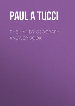
Since 1975, scientists believe that more than 33% of the ozone layer has disappeared. There is a seasonal factor to the reduction in ozone at any given time during the year, too. At different times, the ozone layer naturally declines or rises. But scientists also know that chlorofluorocarbons (CFCs), which are used for air conditioning, aerosol sprays, halon in fire extinguishers, and the interaction of man-made chemicals with nitrogen in our atmosphere directly cause ozone depletion. It is a man-made problem that requires a man-made solution. By 1989, 193 countries signed an agreement, called the Montreal Protocol, limiting the use of CFCs. And by 2011, all countries in the world signed this agreement, which ultimately has had a mitigating effect on the ozone hole, which was being observed as growing over Antarctica. Scientists at NASA who monitor the ozone in our atmosphere believe that the ozone depletion issue for the inhabitants on Earth is no longer a great problem today because concentrations of man-made ozone-depleting chemicals in use have stopped increasing and are actually declining.
This 2013 graphic shows the extent of ozone depletion over Antarctica.
How do CFCs destroy ozone?
When CFCs rise up in the atmosphere to the ozone layer, ultraviolet rays break them down into bromine and chlorine, which destroy ozone molecules.
CLIMATIC TRENDS
What is El Niño?
El Niño (also known as the El Niño Southern Oscillation [ENSO]), is a large patch of warm water that moves between the eastern and western Pacific Ocean near the equator. When the warm water of El Niño, about 1.8 degrees Fahrenheit (1 degree Celsius) warmer than normal, is near South America, the warm water affects the weather in the southwestern United States by increasing rainfall and is responsible for changes in the weather throughout the world. El Niño lasts for about four years in the eastern Pacific Ocean and then returns to the western Pacific near Indonesia for another four years. When the warm water is in the western Pacific, it is known as La Niña, the opposite of El Niño. When La Niña is in action, we have “normal” climatic conditions. Scientists at the National Oceanic and Atmospheric Administration (NOAA) monitor the effects of these types of changes to determine how they may influence our weather each year.
Can people live in a torrid zone?
The ancient Greeks divided the world into climatic zones that were not accurate. The three zones included frigid, temperate, and torrid. They believed that civilized people could only live in the temperate zone (which, of course, was centered around Greece). From Europe northward was part of the inhospitable frigid zone, while most of Africa was torrid. Unfortunately, this three-zone classification system stuck and was later expanded to five zones once the Southern Hemisphere was explored. People identify everything north of the Arctic Circle (near northern Russia) and south of the Antarctic Circle (near the coast of Antarctica) as frigid, everything between the tropics and the Arctic and Antarctic circles as temperate, and the zone between the Tropics of Cancer and Capricorn as torrid.
Where does the name El Niño come from?
The phenomenon of El Niño was discovered by Peruvian fishermen who noticed an abundance of exotic species that arrived with the warmer water. Since this usually occurred around the Christmas season, they called the phenomenon El Niño, which means “the baby boy” in Spanish, in honor of the birth of Jesus Christ. La Niña, the opposite cycle of El Niño, means “the baby girl.”
What are ice core samples and why are they important?
An ice core sample is a thick column of ice, sometimes hundreds of feet long, that is produced by drilling a circular, pipelike device into thick ice and then pulling out the cylindrical piece. Ice core samples from places like Greenland and Antarctica provide scientists with important clues about past climates. Air trapped in the ice remains there for thousands of years, so when scientists collect ice cores, they can analyze the air to determine the chemical composition of the atmosphere at the time the ice was formed. Sediments and tiny bugs are also found in the ice and provide additional clues to the state of the natural world at the time the ice was first deposited.
What is continentality?
Areas of a continent that are distant from an ocean (such as the central United States) experience greater extremes in temperature than do places that are closer to an ocean. These inland areas experience continentality. It might be very hot during the summer, but it can also get very cold in winter. Areas close to oceans experience moderating effects from the ocean that reduce the range in temperatures.
What are the horse latitudes?
Horse latitudes are high-pressure regions, more formally known as subtropic highs, which are warm and don’t have much wind. Legend has it that the lack of wind sometimes caused sailors of the sixteenth and seventeenth centuries to throw their horses overboard in an effort to conserve water on board. That’s how the region, centered around 30° latitude, got its name.
WEATHER
How does land turn into desert?
The process known as desertification is complicated and results from such activities as overgrazing, inefficient irrigation systems, and deforestation. It is most widespread in the Sahel region of Africa, a strip of land along the southern margin of the Sahara Desert. The Sahara grows larger because of desertification. Desertification can be reversed by changing agricultural practices and by replanting forests.
As water use rises due to agriculture and increasing populations, lakes and even small seas are disappearing. The Aral Sea in Uzbekistan, for example, has almost disappeared over the last fifteen years.
What are Fahrenheit and Celsius?
Fahrenheit and Celsius are two common temperature scales used throughout the world. Temperature in Fahrenheit can be converted to Celsius by subtracting 32 and multiplying by five; divide that number by nine, and you have Celsius. Conversely, you can convert Celsius to Fahrenheit by adding 32, multiplying by nine, and finally dividing by five. Kelvin, a system used by scientists, is based on the same scale as Celsius. All you have to do is add 273 to your Celsius temperature to obtain Kelvin. Zero degrees Kelvin is negative 273° Celsius.
What is a low high temperature and a high low temperature?
When meteorologists look at daily temperature, there is always a low and a high temperature for each day. If the high temperature is the coldest high temperature for that day or for the month, you have a new record—a new low high. Conversely, if the low temperature for a day is quite warm and breaks records, that’s a new high low!
Why is it hotter in the city than in the countryside?
Cities have higher temperatures due to an effect known as the urban heat island. The extensive pavement, buildings, machinery, pollution from automobiles, and other things urban cause an increase in warmth in the city. Cities such as Los Angeles can be up to five degrees hotter than surrounding areas due to the urban heat island effect. The term comes from temperature maps of cities where the hotter, urban areas look like islands when isotherms (lines of equal temperature) are drawn.
What are some world weather records?
The following are some amazing weather records. The wettest: Cherrapunji, and the town of Mawsynram nearby in India, near the border of Bangladesh, have the highest average rainfall per year in the world, averaging 467 inches (11,872 mm); the coldest: the East Antarctic Plateau, Antarctica, with a measurement of –136° Fahrenheit (–93.2° Celsius); the driest: Dry Valleys of Antarctica which receives 0 inches (0 centimeters) of rainfall per year; and the hottest: Lut Desert, Iran, which has sizzled at 159.3° Fahrenheit (70.7° Celsius) in five of the seven years from 2004 to 2009.
Why is it more likely to rain in a city during the week than on the weekend?
Urban areas have an increased likelihood of precipitation during the workweek because intense activity from factories and vehicles produce particles that allow moisture in the atmosphere to form raindrops. These same culprits also produce warm air that rises to create precipitation. A study of the city of Paris found that precipitation increased throughout the week and dropped sharply on Saturday and Sunday.
What does a 40% chance of rain really mean?
When the morning weather report speaks of a 40% chance of rain, it means that throughout the area (usually the metropolitan area), there is a four in ten chance that at least 0.001 of an inch of rain (0.0025 centimeters) will fall on any given point in the area.
Why is it more wet on one side of a mountain than the other?
It’s much more wet on one side of a mountain than the other because of a process known as orographic precipitation. Orographic precipitation causes air to rise up the side of a mountain range and cool off, creating storms. The storms deposit a great deal of precipitation on that side of the mountain and create a rain shadow effect on the opposite side of the range. The Sierra Nevada Mountains are an excellent example of orographic precipitation because the mountains of the western Sierras receive considerable rainfall (far more than California’s Central Valley), while the eastern Sierras are quite dry.
Why are there so many discrepancies in the world records of weather?
The discrepancies in the data reflect the length of time that we use to measure weather phenomena. Some records were set by observing the weather over decades; others only occurred during the span of a few years, months, or even hours or minutes.
What is a rain shadow?
When the moisture in the air is squeezed out by orographic precipitation, there’s not much left for the other side of the mountains. The dry side of the mountain experiences a rain shadow effect because they are in the shadow of the rain.
What is a thunderstorm?
Thunderstorms are localized atmospheric phenomena that produce heavy rain, thunder and lightning, and sometimes hail. They are formed in cumulonimbus clouds (clouds that are big and bulbous) that rise many miles into the sky. Most of the southeastern United States has over forty days of thunderstorm activity each year, and there are about 100,000 thunderstorms across the country annually. Thunderstorms are different from typical rainstorms because of their lightning, thunder, and occasional hail.
What are monsoons?
Occurring in southern Asia, monsoons are winds that flow from the ocean to the continent during the summer and from the continent to the ocean in the winter. The winds come from the southwest from April to October and from the northeast (the opposite direction) from October to April. The summer monsoons bring a great deal of moisture to the land. They cause deadly floods in low-lying river valleys, but they also provide the water southern Asia relies upon for agriculture.
What is the origin of the word “monsoon”?
The word “monsoon” comes from several source languages, including from the Portuguese word moncau, the Arabic word mawsim, and the early Dutch word monsun.
WIND
What are dust devils?
These columns of brown, dust-filled air, which can rise dozens of feet, are not as evil as the name suggests. They are caused by warm air rising on dry, clear days. Winds associated with dust devils can reach up to 60 miles (96.5 km) per hour and cause some damage, but they are not as destructive as tornadoes and usually die out pretty quickly.
What causes the wind to blow?
The Earth’s atmospheric pressure varies at different places and times. Wind is simply caused by the movement of air from areas of higher pressure to areas of lower pressure. The greater the difference in pressure, the faster the wind blows. Some detailed weather maps show wind speed along with isobars (areas of equal air pressure) indicating the level of air pressure.
In which direction does the west wind blow?
It blows from the west to the east. Wind direction is always named after the direction from where it originates.
What is the jet stream?
The jet stream is a band of swiftly moving air located high in the atmosphere, meandering across the troposphere and stratosphere, up to 30 miles high (48 km). The jet stream affects the movement of storms and air masses closer to the ground.
Dust devils are like very weak tornadoes that never cause any damage.
What are the westerlies?
These westerly winds flow at mid-latitudes (30 to 60 degrees north and south of the equator) from west to east around the Earth. The high-altitude winds known as the jet stream are also westerlies.
What is katabatic wind?
Katabatic wind is high-density air that moves from a higher elevation down a slope because of the force of gravity. These winds are sometimes known as “fall winds.”
What is the windiest place on Earth?
Because of katabatic winds, Antarctica frequently wins the top honors for being the windiest place on Earth. Winds near Commonwealth Bay, which was discovered in 1912, are frequently recorded to be 150 miles per hour (240 km per hour), with an average wind speed over the course of a year of 50 miles per hour (80 km per hour).
What is a willy-willy?
Willy-willy is a word that traces its roots to indigenous Australian language. It is a term used to describe a dust devil, when air is heated up on the ground, drawing forcefully nearby cooler air, causing the air to spiral upward.
Is Chicago really the “Windy City”?
Chicago is not the windiest big city in the lower 48 states of the United States. Chicago’s average wind speed of 10.3 miles (16.58 km) per hour is beat by Boston (12.3 mph/19.79 kph), Dallas (10.7 mph/17.22 kph), Oklahoma City (12.2 mph/19.63 kph), Buffalo (11.8 mph/18.99 kph), and Milwaukee (11.5 mph/18.51 kph).
What is the origin of the name “Windy City”?
Although Chicago is not really that windy compared with other American cities, the name has been used since the nineteenth century. It refers not necessarily to the weather but to the observations by many when describing Chicago politicians, metaphorically, as “talkative,” “boastful,” and “self-promoting.”
What world weather record does the United States hold?
The United States claims the world’s highest surface wind, 318 miles per hour (511.77 km per hour), during a tornado in Oklahoma in 2009.