Читать книгу The Handy Geography Answer Book - Paul A Tucci - Страница 12
На сайте Литреса книга снята с продажи.
ОглавлениеTHE PHYSICAL ENVIRONMENT
THE EARTH’S MATERIALS AND INTERNAL PROCESSES
What are the three main layers of the interior of the Earth?
Scientists do not know very much about what is below the surface of our planet. But we do know that it is divided into three layers: crust, mantle (upper and lower), and core (outer and inner).
How thick is the Earth’s crust?
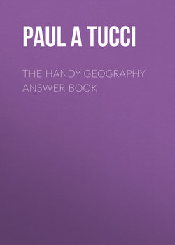
The thickness of the Earth’s crust varies at different points around the planet. Under continents, the crust is approximately 27–31 miles (45–50 km) thick, but under the oceans, it is a mere 6.2 miles (10 km) thick, usually surrounded by an 18-mile- (30-km-) thick contour.
What did Alfred Wegener discover?
Although Wegener was not the first to discover that the continents seem to appear to fit together like pieces of a jigsaw puzzle, he was the first to create a theory that the continents seemed to have drifted apart, in 1912. His original paper was entitled “The Formation of the Major Features of the Earth’s Crust (Continents and Oceans).” It was not until long after his death in 1930 that modern technology and scientific analyses proved that he was correct.
What is continental drift?
The Earth is divided into massive pieces of crust that are called tectonic plates. These plates lie wedged together like a puzzle. The plates slowly move, crashing into each other to form mountain ranges, volcanoes, and earthquakes. The plates are like rafts floating on water; this is called continental drift. By 1968, the theory of continental drift was gradually replaced by the theory of plate tectonics.
This contour map indicates the differing levels of thickness in the Earth’s crust as marked in ten-kilometer (six-mile) intervals.
How do we know that the continents were once joined together?
There is extensive evidence, dating back many millions, perhaps billions, of years, that the continents were joined together. Fossil evidence of plant and animal life that are similar have been found on different continents, as well as similar glacial sediment.
How many tectonic plates are there?
There are seven significant plates on the planet. Some of the largest include the Eurasian Plate, North American Plate, South American Plate, African Plate, Indo-Australian Plate, Pacific Plate, and Antarctic Plate. Some smaller plates are located between the major plates. The smaller plates include the Arabian Plate (containing the Arabian Peninsula), the Nazca Plate (located to the west of South America), the Philippine Sea Plate (located southeast of Japan, containing the northern Philippine islands), the Indian Plate (containing Southeast Asia, India, and South China to Eastern Indonesia), the Cocos Plate (located southwest of Central America), the Juan de Fuca Plate (just off the coast of Oregon, Washington, and Northern California), and the Caribbean Plate (beneath Central America and the Caribbean Sea).
Pangea was a supercontinent that existed about 200 million years ago. It gradually separated into two large continents—Laurasia and Gondwana—about 120 million years ago, and then those continents divided further over time.
What type of rocks are formed by lava?
Igneous rocks are formed when liquid magma under the surface of the Earth, or lava on the surface of the Earth, cools and hardens into rock.
What type of rocks are formed from particles?
Sedimentary rocks are formed by the accumulation and squeezing together of layers of sediment (particles of rock or remains of plant and animal life) at the bottom of rivers, lakes, and oceans or even on land. The continual accumulation of more and more layers of sediment places a great amount of pressure on the lowest layers of sediment and, over time, compresses them into rock.
What are recycled rocks?
Metamorphic rocks are rocks that had a prior existence as sedimentary, igneous, or other metamorphic rocks. Underground heat and pressure metamorphose or change one type of rock into another, creating a metamorphic, or recycled, rock.
What type of sand do we often see on beaches near volcanoes?
Because the content of the sediment near volcanoes is comprised of dark black igneous rock, the resulting beach sand in such places as Hawaii and Indonesia is actually a dark brown or even black in color.
Which is larger, clay or sand?
A single grain of sand is 1,500 times larger than a grain of clay.
What is a dike?
A dike is magma that has risen up through a crack between layers of rock. When this magma solidifies, it becomes very solid rock. If the rock around it is eroded, a dike can form great rock monoliths above the ground.
What are hot springs?
Hot springs are created by underground water that is heated and percolates to the Earth’s surface. Aside from being natural baths, the steam from hot springs can be used to drive turbines, which create electricity. This type of energy production is called geothermal energy.
Sinkholes have become a growing problem in the United States, destroying roads and sometimes even swallowing houses.
Where are hot springs used by people around the world?
Hot spring baths have been used in cultures throughout the world since ancient times. They are found in such places as Japan, Taiwan, Australia, the United States, Iceland, and Sicily.
Why does the ground sink?
In many places around the world, seemingly solid land lies over vast oil deposits or water aquifers. Without the liquid supporting it, the ground sinks into the space left behind. In some parts of California’s Imperial Valley, the land has dropped more than 25 feet (7.6 meters) due to underground water being removed from the area. Unless the pumping of underground water and oil is stopped, the land will continue to sink.
Why do houses fall into sinkholes?
Houses that sit upon limestone rock have the proclivity to fall into sinkholes. As underground water wears away the limestone rock, it creates underground caverns. If the water wears away too much limestone, the cavern may collapse, taking anything on the surface with it. A sinkhole is just one of the many reasons to have your home inspected by a geologist.
NATURAL RESOURCES
What is a renewable resource?
A renewable resource is one that can be replenished within a generation. Forests, as long as they are replanted, are a renewable resource. Materials such as oil, coal, and natural gas are known as nonrenewable resources because they require millions of years to be created. So, once the world’s supply of oil is gone, it’s gone for a long, long time.
When will we run out of oil on Earth?
Scientists estimate that there are approximately 1.3 trillion barrels of oil on reserve (not yet pumped) in the world’s oil fields, deep beneath the Earth. Debate continues whether or not we have reached the point of maximum production of this oil, which is called “peak oil.” Based upon today’s rate of demand and consumption, many experts believe that we have approximately 40 years before the world’s oil supplies will be nearing depletion. Many other scientists believe that new technologies and findings will enable the world to extend this period past this date. By 2040, many forecast that the production of oil will be 20% of what it is today. Because of technology, like horizontal drilling and fracking, used to extract oil from relatively inaccessible places, we may delay the time when the world runs out of oil.
What are perpetual resources?
Perpetual resources are natural resources, such as solar energy, wind, and tidal energy, that have no chance of being used in excess of their availability. They can be used for power generation and conversion to electric energy indefinitely.
What are fossil fuels?
Underground fuels such as natural gas, oil, and coal are all known as fossil fuels because they are encased in rocks, just like fossils. It takes millions of years of compression and the building up of dead plants, animals, and organic material to create these fuels.
What is a fossil?
The outline of the remains of a plant or animal embedded in rock is called a fossil. Fossils are formed when a plant or animal dies and becomes covered up by sediments. Over time, the layers compress the remains, which are then embedded into the rock.
LANDSCAPES AND ECOSYSTEMS
What are basins and ranges?
Basins and ranges are sets of valleys and mountains that are spaced close together. Most of Nevada and the western part of Utah are composed of sets of basins and ranges.
What is permafrost?
Permafrost describes ground (including soil, rock, organic material, and ice) that is permanently at or below 32 degrees Fahrenheit (0 degrees Celsius) for a minimum of two consecutive years. Its thickness depends on location but can extend from 9.94 to 4,921 feet (3 meters to 1,500 meters) beneath the surface. Permafrost occurs in higher latitudinal regions, which have cold climates.
Is the permafrost thawing?
Yes, the permafrost is thawing. In places with great areas of permafrost, such as Alaska, the permafrost has warmed to the highest level in 10,000 years. During the last 50 years, the Arctic regions have been warming to record-high temperatures. During this time, Alaska’s average temperature has warmed an average of 3.3 degrees above normal.
Why is permafrost so important?
Aside from the mediating effects on the Earth’s temperature, permafrost provides a cover for the habitat that supports wild flora and fauna, which provide sustenance for the entire ecosystem of the Arctic regions, including the many indigenous people who live there. Permafrost also covers organic rich sediment that contains methane hydrates, which may be released into the air as “greenhouse gases.” As the permafrost thaws, these greenhouse gases are released into the atmosphere and may contribute to global climate change. Permafrost makes up 24% of all land in the Northern Hemisphere.
What are greenhouse gases?
Greenhouse gases are chemical compounds that absorb and emit thermal radiation, are present in our atmosphere, and allow direct sunlight to reach the Earth’s surface. But as the heat bounces back from the Earth to the atmosphere, the gases absorb this energy, and less heat from the surface of the Earth is able to escape back into the atmosphere and is trapped in the lower atmosphere. Many greenhouse gases are found in nature, like carbon dioxide, water vapor, methane, nitrous oxide, and ozone, and are regulated by a process called the carbon cycle. The trouble is that man-made greenhouse gases from chlorofluorocarbons (CFCs), hydrofluorocarbons (HFCs), perfluorocarbons (PFCs), and carbon dioxide created by man-made activities such as the burning of forests and the use of fossil fuels (coal, oil, and natural gas) cause these gaseous emissions to unnaturally rise. For example, human activity causes carbon, which exists in nature in a solid form (as coal), to move to a gaseous form, increasing the concentrations of these gases in our atmosphere.
Evidence is piling up that greenhouse gases from human industry are contributing to global warming of the planet.
When did man-made greenhouse gases begin to be an issue for mankind?
Scientists believe that man-made greenhouse gases began when people began to burn coal at the beginning of the Industrial Revolution in 1750. Measurements of carbon dioxide occurring in our atmosphere in the present day, compared to 1750, show a 40% increase. Experts believe this is a major contributor to the effects of a phenomenon called global warming. The effects of the sudden warming impacts many aspects of our global ecosystem, including our marine ecology, the lives of billions of people, the air that we breathe, and the increase in surface temperatures felt throughout the world.
What percentage of animal species have become extinct over the last 40 years?
According to a 2014 report issued by experts at the World Wildlife Fund, 52% of all animal species on our planet have become extinct in the past 40 years, due to the degradation of our environment.
What is the cryosphere?
The cryosphere is the area of the Earth where water has solidified and includes ice, floating ice, glaciers, permafrost, and snow.
How much of the Earth’s surface is frozen?
About one-fifth of the planet is permafrost, or frozen for all or most of the year.
What do deserts and polar regions have in common?
Deserts and polar regions both have average rainfall of less than four inches (10 cm) per year. Both regions contain some of the driest places on Earth.
What is a jungle?
A jungle is a forest that is composed of very dense vegetation. The term tropical rain forest can often be used interchangeably with jungle. Jungles occur most often in tropical areas such as the Amazon and Congo river basins.
What is a rain forest?
A rain forest is any densely vegetated area that receives over 40 inches (100 centimeters) of rain a year.
What is a tropical rain forest?
A tropical rain forest is a rain forest that lies between the Tropic of Cancer in the north (northernmost latitude around the Earth, where the sun appears directly overhead during the Northern Solstice) and the Tropic of Capricorn in the south (the southernmost latitude around the Earth, where the sun appears directly overhead during the Southern Solstice) or within the “tropics.” Tropical rain forests are known for their very diverse species of plant and animal life. Tropical rain forests exist throughout Central America, northern Brazil, the Congo River Basin, and Indonesia.
Where is the northernmost rain forest?
Juneau, the capital of Alaska, is in the middle of one of the largest and most northerly rain forests in the world, which is located within the Chugach National Forest and Chugach State Park. Other rain forests extend to the northern regions of Japan and Siberia, Russia.
What is a desert?
A desert is an area of light rainfall. Deserts usually have little plant or animal life due to the dry conditions. Contrary to the popular image, deserts are not just warm, sand-swept areas like the Sahara Desert; they can also be frigid areas like Antarctica, one of the driest places on Earth.
How can an area be lower than sea level?
Land in the midst of a continent can be lower than sea level because the land is not close enough to the sea to be flooded with water. Movement of the tectonic plates pushes areas like the Dead Sea in Israel and Death Valley in California to elevations lower than sea level.
What was the highest temperature ever recorded?
World temperature records have been sources of controversy for many years, with many temperature records decertified by such groups as the World Meteorological Organization. For example, the world’s highest temperature, thought to have been recorded in error in the desert in Libya in 1922 as 136 degrees Fahrenheit (57.78 degrees Celsius) was decertified in 2012. California’s Death Valley, in the United States, holds the record set in 1913 for the highest temperature in the world of 134 degrees Fahrenheit (56.7 degrees Celsius).
Do oases really exist?
Oases do exist and they are quite prevalent throughout the eastern Sahara Desert in Africa. An oasis has a source of water, often an underground spring, that allows vegetation to grow. Small towns are located at some larger oases in the desert. Oases have been traditional stopping places for nomads traveling across deserts.
How do sand dunes move?
Sand dunes are created and transported by wind. Wind blows sand from the windward side of the dune to the opposite side, slowly transporting it across the landscape.
What causes erosion?
Wind, ice, and water are the most common agents of erosion. They wear down and carry away pieces of rock and soil. The process is accelerated when trees that help hold the soil in place have been destroyed by fire or have been chopped down. With fewer trees, the soil is easily eroded and washed away, leaving a barren surface where plants can no longer grow.
What does a glacier leave behind?
When a glacier moves across the land, it acts like a giant bulldozer, pushing and collecting rock, dirt, and debris. A moraine is a deposit of rock and dirt carried by a glacier and left behind once the glacier melts and recedes.
What is a tree line?
A tree line is the point of elevation at which trees can no longer grow. The tree line is caused by low temperatures and frozen ground (permafrost).
Glaciers retreating as the last ice age ended left behind the spectacular valley and mountains of Yosemite National Park.
How high is a tree line?
Tree lines vary, depending on where they are in the world and how close they are to a geographic pole. Trees stop growing in mountain regions from around 2,600 feet (800 meters) in places such as Sweden to over 17,000 feet (5,200 meters) in the Andes Mountains in Bolivia.
How do forest fires help forests?
An occasional fire is often necessary for a forest. Forest fires clear undergrowth, giving more room for trees to grow, thus rejuvenating the forest. Since forest fires are usually extinguished by firefighters as rapidly as possible, the amount of undergrowth in forests has increased. This extra undergrowth can become extremely flammable, making fires even more dangerous to people. It is thought by many experts that a policy of allowing the forest to burn naturally, while protecting human structures, produces a more natural environment.
What is tundra?
A tundra is a dry, barren plain that has significant areas of frozen soil or permafrost. Tundra is common in the northernmost parts of North America, Greenland, Europe, and Asia. Although rather inhospitable, there is plant life on the tundra. This life consists of low, dense plants such as shrubs, herbs, and grasses. There are even some species of insects and birds that can survive the harsh conditions of tundra.
ASTEROIDS AND NEAR EARTH OBJECTS
Did an asteroid cause a mass extinction of the dinosaurs?
Known as the Cretaceous-Paleogene extinction event approximately 66 million years ago, a six-mile wide (about 10 km) asteroid struck the Earth. Most scientists believe that this impact might have started a chain of events that led to the extinction of between 71% and 81% of the Earth’s species of animals and plants, including nonavian dinosaurs. Today’s birds, having evolved from surviving dinosaurs over millions of years of evolution, continue living, even after such an event. Many scientists believe that an asteroid that large would have created a layer of dust that would have surrounded the Earth, lowering temperatures and causing deadly, highly acidic, rain.
Will another large asteroid strike the Earth?
Yes, asteroids have struck the Earth in the past and are likely to strike again in the future. Small asteroids strike the planet about every 1,000 to 200,000 years. Large asteroids are much less likely to threaten the planet; they strike only about three times every million years. Huge asteroids, such as the one that may have killed dinosaur species, are even less frequent.
How many places on Earth have evidence of asteroid impacts?
There are about 160 places on Earth that display evidence of asteroid impacts. Depending on the size of an asteroid, it can have significant effects on the planet. If an asteroid strikes the ocean, it can create huge, destructive tsunamis or tidal waves. If an asteroid strikes land, it can create a huge crater, cause earthquakes, and propel debris into the atmosphere, creating major climatic changes.
What is a Potentially Hazardous Asteroid (PHA)?
A PHA is an object that is 3.28 feet (1 meter) in length, which is large enough to be detected by astronomers on Earth. It has an orbital path that could bring it in close proximity to Earth. It is very hard to predict the orbital path of a PHA, since its trajectory is always influenced by its proximity to a nearby planet’s gravitational pull.
How much junk is orbiting our planet?
According to scientists at NASA who track orbital debris, there are approximately 500,000 pieces traveling around the Earth, some at speeds of up to 17,500 miles per hour, from tiny screws to booster rockets. Of the 500,000 pieces, more than 20,000 pieces are larger than a softball. Some are as small as flecks of paint, which may damage orbiting spacecraft like the International Space Station, because of their speed. NASA, the U.S. Department of Defense, and other space agencies are able to track about 21,000 pieces of debris.
There are essentially two levels of space junk around our planet: objects in geosynchronous orbit and those in low Earth orbit.
How many Potentially Hazardous Asteroids is NASA tracking that could impact the Earth in the twenty-first century?
There are approximately 1,572 PHAs that are on NASA’s list of most likely objects whose orbital paths may bring them close to the Earth’s orbit sometime in the next 100 to 200 years. Scientists have not fully calculated the risks because they still need to figure out the effects of gravity of various planetary bodies on the exact course of the asteroids. At best, scientists may calculate the probability of a collision with Earth, during a certain period of time.
What is a Near Earth Object (NEO)?
A Near Earth Object is any object in space that is relatively close to Earth and is of any size. The difference between an NEO and a Potentially Hazardous Asteroid (PHA) is that PHAs are anything larger than 500 feet (150 meters) in diameter and have orbits that bring them closer than 4,650,000 miles (7,480,000 km) to Earth. All PHAs are also NEOs, but not all NEOs are PHAs.
How many Near Earth Objects is NASA tracking?
Since the first Near Earth Object was discovered in 1973, approximately 12,000 objects are currently being tracked by NASA.
When and where was the last great impact on the Earth from a Near Earth Object?
The last big impact was in June of 1908 in Tunguska, Russia, in Siberia. Scientists do not know for sure what hit the Earth, as it could have been a comet or asteroid. But whatever it was, it had an estimated explosive energy of fifteen megatons. The impact event is significant because it was the first time during the modern era that we had eyewitness accounts by locals living nearby. The object is estimated to have been 120 feet (36.58 meters) wide and traveled at a speed of 33,500 miles per hour (53,913 km/hr).
What is the Space Guard Survey?
The Space Guard Survey refers to many initiatives by organizations such as NASA to catalogue all Near Earth Objects that are larger than 0.6 miles (1 kilometer) in diameter. The survey assesses their potential intersection with Earth’s orbital path to determine if they are a threat.