Читать книгу Afoot and Afield: San Francisco Bay Area - David Weintraub - Страница 20
На сайте Литреса книга снята с продажи.
ОглавлениеTRIP 6 Angel Island State Park
| Distance | 4.5 miles, Loop | |
| Hiking Time | 2 to 3 hours | |
| Elevation Gain/Loss | ±800 feet | |
| Difficulty | Moderate | |
| Trail Use | Good for kids | |
| Best Times | All year | |
| Agency | CSP | |
| Recommended Map | Angel Island State Park (CSP) | |
| Notes | Bicycles are not allowed on the trails described below, but can be used on the island-circling system of main roads, and can be brought to the island on ferries |
HIGHLIGHTS Angel Island is a sentinel, guarding the entrance to San Francisco Bay. This route uses the Northridge and Sunset trails to circle the island, and also visits its highest point, Mt. Caroline Livermore (781’), a superb vantage point from which all the familiar landmarks in the Bay Area are revealed. There is much historic interest to the island as well, and an outing here can easily include a tour by bicycle or tram.
DIRECTIONS The most frequent ferry service to Angel Island leaves from Tiburon, (415) 435-2131, www.angelislandferry.com. There is also ferry service from San Francisco, (415) 773-1188, www.blueandgoldfleet.com; and from Oakland/Alameda, (510) 522-3300, www.eastbayferry.com. There is no weekday ferry service to Angel Island during the winter; be sure to check for the most current schedule before departing. There are fees for ferry service and park entrance (the CSP annual day-use pass is not accepted here).
FACILITIES/TRAILHEAD Near the ferry landing are a visitor center, café, picnic tables, restrooms, water, phone, lockers, bike rentals, and tour trams. State park volunteers provide interpretive programs at the island’s historic sites on weekends and holidays from May through October. For tram tours, call (415) 897-0715. For camping and group picnicking reservations, call (800) 444-7275. The trailhead is on the northeast side of the ferry landing, to the left of the restrooms and phone.
Angel Island, the largest island in San Francisco Bay, has played a role in the area’s history for thousands of years. Coast Miwok Indians used the island as a fishing and hunting site. In August 1775, the first European to enter the bay, Juan Manuel de Ayala, anchored his ship San Carlos in a cove on the island’s northwest side that now bears his name.
During both world wars, Angel Island served the U.S. military as an embarkation/debarkation point and also as a prison for enemy aliens and prisoners of war. Following World War II, the island was declared surplus property, and a campaign was started to make it a state park. Mt. Caroline Livermore, the island’s 781-foot high point, honors a leading Marin County conservationist who spearheaded the campaign.
A little-known aspect of the island is its history as a detention center for immigrants, 97 percent of them Chinese, from 1910 to 1940. The detainees, who were held from two weeks to six months, faced tough questioning about their family and village background. Thanks to the efforts of the late Paul Chow, head of the foundation to restore Angel Island, the Immigration Station on the island’s northeast side is now a museum.
Climb steeply on the Northridge Trail past several picnic areas to Perimeter Road, the island’s main paved thoroughfare. Cross the road, turn right, and in about 50 feet find the continuation of the Northridge Trail. A dramatic view extends west from here to Tiburon, the Marin Headlands, and Mt. Tamalpais. Now the grade eases to a gentle uphill as you alternate between forest and clearings full of wildflowers.
As the trail curves around the north side of the island, you encounter a densely overgrown area where California bays rise above a shrubby understory. Carpets of forget-me-nots, abundant in the island’s shady enclaves, put on a fabulous spring and summer display of light blue flowers. Suddenly the terrain opens, and you cross a sandy, rocky area dominated by manzanita.
As the trail curves right, you enjoy a ridgetop walk and then reenter dense forest. Just shy of 1 mile, you reach a dirt fire road which, like Perimeter Road, circles the island. Here you turn left, and about 75 feet ahead find the continuation of the Northridge Trail on your right. Now circling the island’s east side, the route switchbacks right and climbs into a large wildflower meadow, and soon offers views of Mt. Livermore, the island’s summit.
Alien Trees
The state park has cleared many eucalyptuses and a lesser number of Monterey pines, both nonnative, from the island in an effort to prevent their spread and encourage native plants. Stumps beside the trail are evidence of this project.
At a Y-junction you leave the Northridge Trail and turn sharply right to contour across a grassy slope dotted with coyote brush and other native shrubs. The single-track trail switchbacks twice, then ascends west along a ridgeline. Nearing the summit, you pass two sets of picnic tables set on concrete platforms (the platforms are remnants of a Nike missle radar site). The very top of Mt. Livermore has been restored and revegetated, based on historical photographs.
Atop the summit are more picnic tables, from which you can enjoy fine views of San Francisco, the Golden Gate Bridge, the Pacific Ocean, and some of the Bay Area’s tallest peaks — Mt. St. Helena, Mt. Hamilton, Mt. Diablo, and Mt. Tamalpais. From here the trail descends to a vantage point on the west side of the peak and dead-ends. When you have finished enjoying Mt. Livermore, retrace your route to the junction with the Northridge Trail at the previously mentioned Y-junction.
From here, angle right and soon reach a paved road. (The old paved route to the summit, right, has been regraded and replanted, and soon it will disappear.) You turn left and, after about 50 feet, swing sharply right on the Sunset Trail.
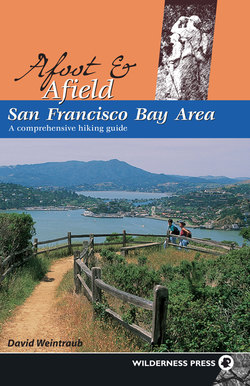
Angel Island State Park: hikers nearing Mt. Livermore enjoy view across Raccoon Strait.
The Sunset Trail, which traverses the south flank of Mt. Livermore, one of the best places on the island for spring wildflowers. After crossing a closed trail, your route curves right and, at about 3 miles, enters forest. When you reach the dirt fire road, bear right and find the continuation of the Sunset Trail about 75 feet ahead and on your left.
Raccoon Strait
Depending on the tide, Raccoon Strait, named for a 19th century British warship that was repaired in Ayala Cove, may be blue-green with water from the Pacific, or muddy brown with runoff from the Sacramento and San Joaquin rivers.
The trail turns left and begins a series of switchbacks (please stay on the trail). You descend through a wooded area to Perimeter Road, where you also meet a paved road rising from Ayala Cove. Cross Perimeter Road and descend the paved road to Ayala Cove, past a bike trail, right, and another paved road, left. Continuing straight, you follow the paved road as it passes the visitor center and lawn, soon arriving at the ferry loading dock. (There are different waiting areas for each ferry, so be sure to get in the right one.)